

Met1985
-
Posts
16,909 -
Joined
-
Last visited
Content Type
Profiles
Blogs
Forums
American Weather
Media Demo
Store
Gallery
Everything posted by Met1985
-

2023-2024 Fall/Winter Mountain Thread
Met1985 replied to The Alchemist's topic in Southeastern States
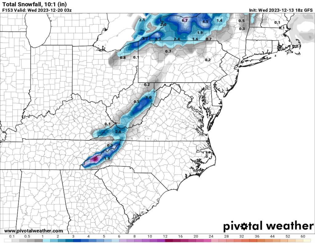
06z gfs looks meh. Sent from my SM-G998U using Tapatalk.thumb.jpg.57774bf1b023d006974d44b14c029270.jpg)
-
2023-2024 Fall/Winter Mountain Thread
Met1985 replied to The Alchemist's topic in Southeastern States
NAM is way east. We might have a decent weekend. Sent from my SM-G998U using Tapatalk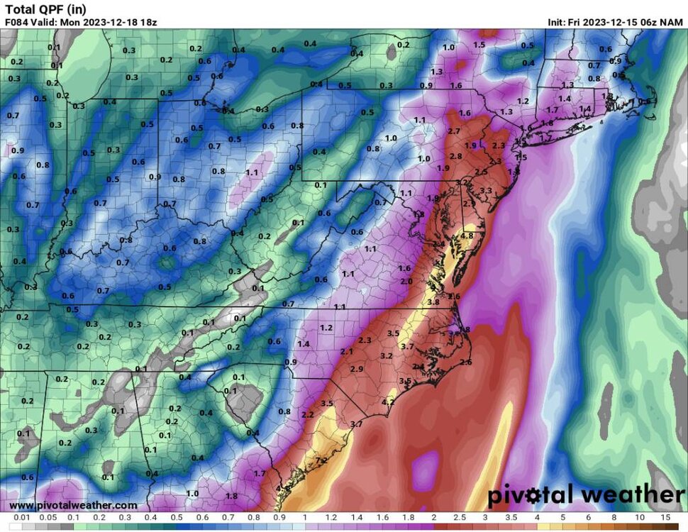
-
2023-2024 Fall/Winter Mountain Thread
Met1985 replied to The Alchemist's topic in Southeastern States
A little snow from the Euro but the further north and east this trends the more of a non event this will be. Sent from my SM-G998U using Tapatalk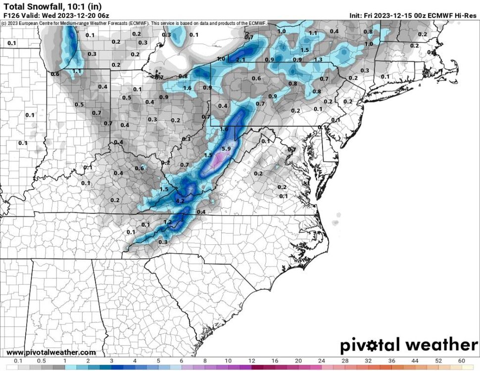
-
2023-2024 Fall/Winter Mountain Thread
Met1985 replied to The Alchemist's topic in Southeastern States
Euro says not a bad weekend. Sent from my SM-G998U using Tapatalk
-
2023-2024 Fall/Winter Mountain Thread
Met1985 replied to The Alchemist's topic in Southeastern States
Gfs moves the system further east. Sent from my SM-G998U using Tapatalk
-
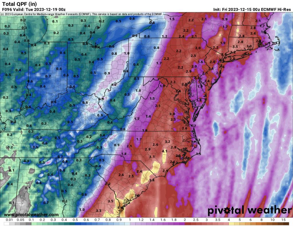
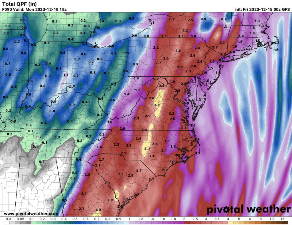
Don't look at the totals coming out of the mountains. I'm worried about flooding here then a paste job.
-
2023-2024 Fall/Winter Mountain Thread
Met1985 replied to The Alchemist's topic in Southeastern States
Yeah no kidding! Going from getting 3 plus inches of rainfall to 2 feet of heavy wet snow. Talk about a worst case scenario of sorts. -
2023-2024 Fall/Winter Mountain Thread
Met1985 replied to The Alchemist's topic in Southeastern States
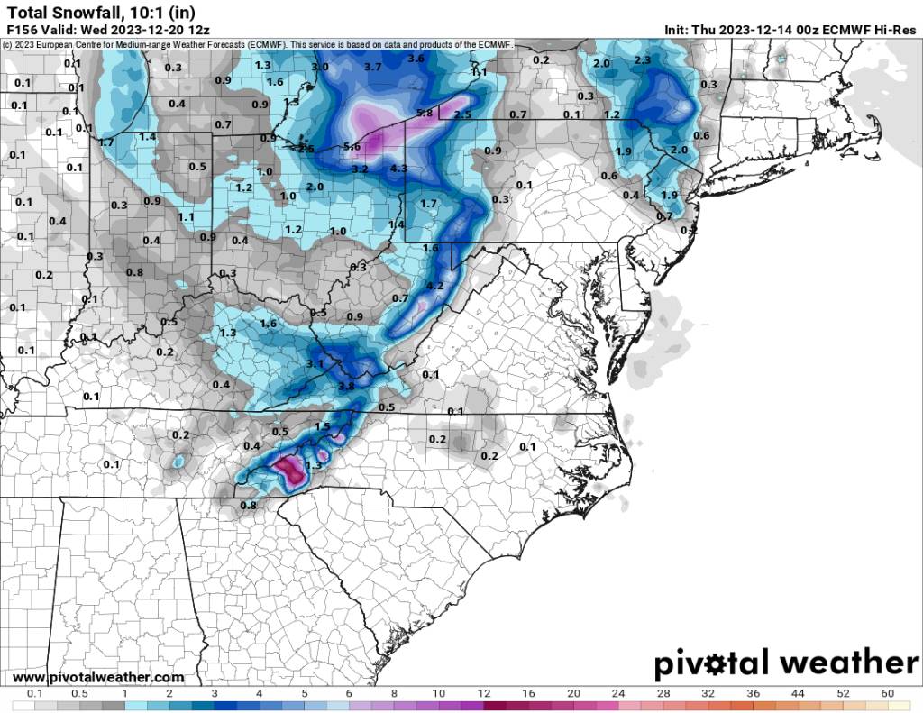
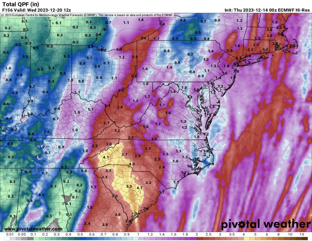
00z euro says I've got your high elevation snow and a very strong vort that rolls in and brings flow snow.... Sent from my SM-G998U using Tapatalk
-
2023-2024 Fall/Winter Mountain Thread
Met1985 replied to The Alchemist's topic in Southeastern States
00z euro says I'll end the drought with one storm. This would be a problem even in drought areas. Too much water all at once. Sent from my SM-G998U using Tapatalk
-
2023-2024 Fall/Winter Mountain Thread
Met1985 replied to The Alchemist's topic in Southeastern States
Looks fun. I mean especially that kind of wind whistling through the mountains. A rare event if this comes for fruition. -
2023-2024 Fall/Winter Mountain Thread
Met1985 replied to The Alchemist's topic in Southeastern States
Yeah you are exactly right. These tricky ULLS can bring big surprises to the mountains. -
2023-2024 Fall/Winter Mountain Thread
Met1985 replied to The Alchemist's topic in Southeastern States
18z gfs Sent from my SM-G998U using Tapatalk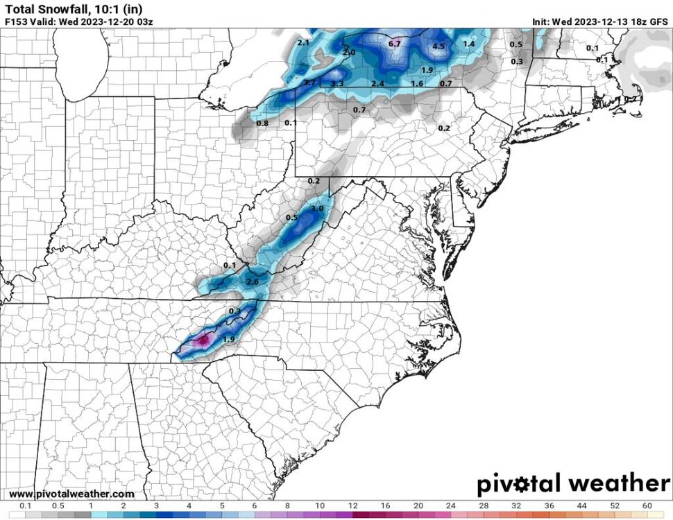
-
December 2023 Mid/Long Term Pattern Discussion: Let it Snow!
Met1985 replied to John1122's topic in Tennessee Valley
Haywood County right on the TN/NC border. At 3500 feet. -
December 2023 Mid/Long Term Pattern Discussion: Let it Snow!
Met1985 replied to John1122's topic in Tennessee Valley
It's crazy how different over the mountains are from some of yall. We had two snows last week, temps in the teens and 30s, we still have snow across the mountains and we could be looking at a big high elevation event this weekend. A warm December was always on the table and very well forecast. I wouldn't fret yet. -
2023-2024 Fall/Winter Mountain Thread
Met1985 replied to The Alchemist's topic in Southeastern States
Yeah I'm not surprised and the Euro isn't even close to this solution. Euro barely has any rain for us at all. Still a lot to figure out but hey something to track. -
2023-2024 Fall/Winter Mountain Thread
Met1985 replied to The Alchemist's topic in Southeastern States
This is with the same system that would bring us lots of rainfall but this would be an elevation dependant snow which could put down feet not inches but feet of snow. Sent from my SM-G998U using Tapatalk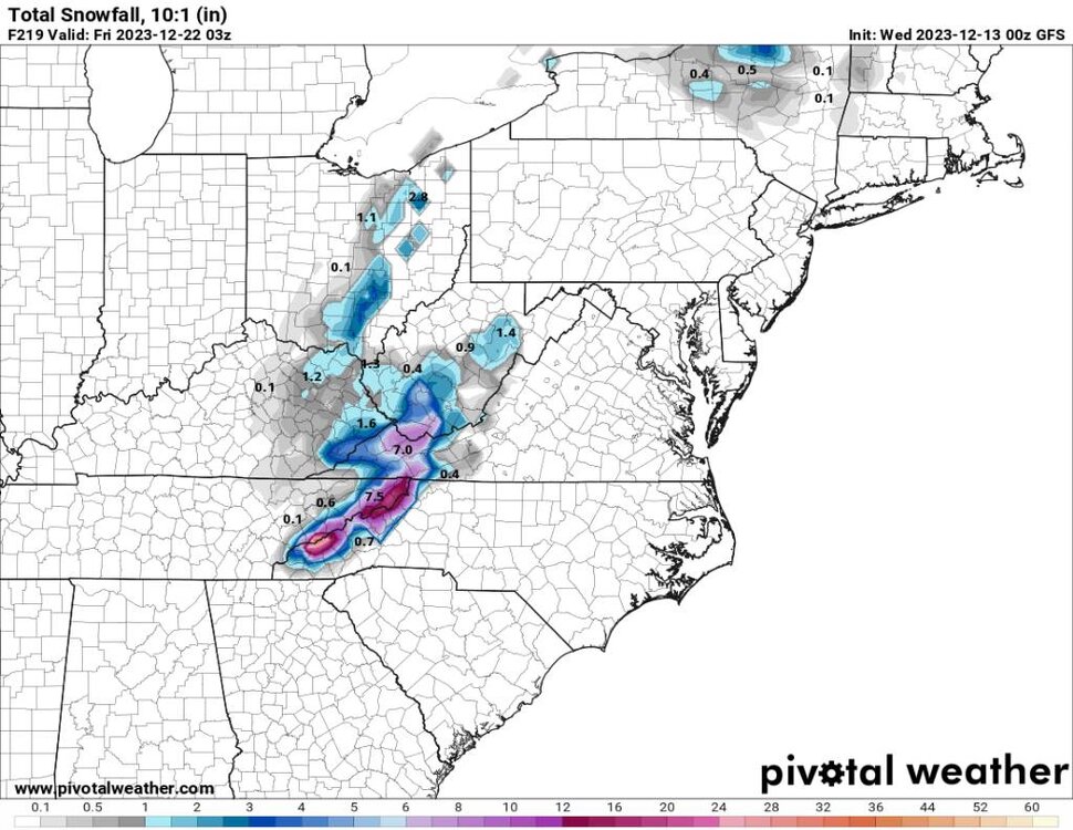
-
2023-2024 Fall/Winter Mountain Thread
Met1985 replied to The Alchemist's topic in Southeastern States
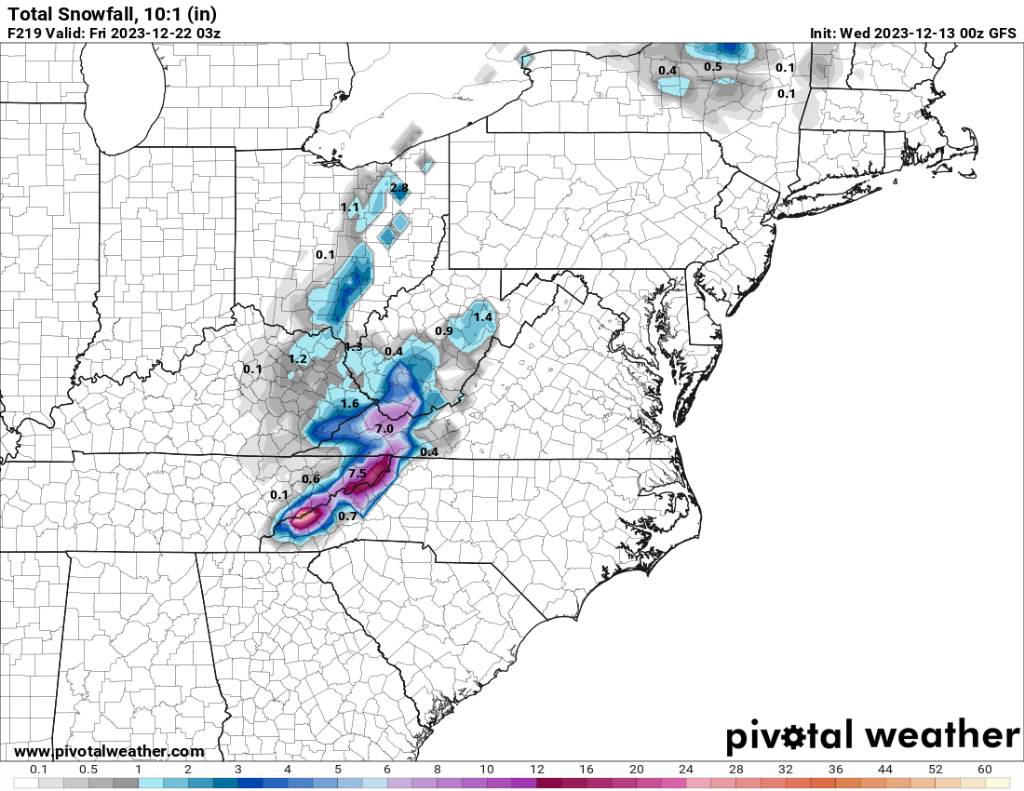
This is a complex system with many many features but this is exactly what we need. Sent from my SM-G998U using Tapatalk.thumb.jpg.3bb4390f3a730df00d281dea4534a06b.jpg)
-
2023-2024 Fall/Winter Mountain Thread
Met1985 replied to The Alchemist's topic in Southeastern States
16 this morning with frosted tips on everything. -
2023-2024 Fall/Winter Mountain Thread
Met1985 replied to The Alchemist's topic in Southeastern States
Yeah down to 20 here currently. Bone chilling with a very heavy frost already. -
2023-2024 Fall/Winter Mountain Thread
Met1985 replied to The Alchemist's topic in Southeastern States
Yeah I was thinking today shoot let's get the water tables back up then let's get some great snows. I'd like to see about three more storms that produce 3 plus inches of rainfall this month. -
2023-2024 Fall/Winter Mountain Thread
Met1985 replied to The Alchemist's topic in Southeastern States
Yeah no kidding. Tomorrow's commute is going to be tricky. -
2023-2024 Fall/Winter Mountain Thread
Met1985 replied to The Alchemist's topic in Southeastern States
Crazy man. Only a dusting here but heck I'll take it. Current temp is 30 and yes the wind is ripping. -
2023-2024 Fall/Winter Mountain Thread
Met1985 replied to The Alchemist's topic in Southeastern States
Well we finally got an overperforming event in rainfall. We've needed this for months and this was not forecast to be but maybe an inch or two max. Instead a lot of people saw 2.5 to 4 inches of rainfall. -
2023-2024 Fall/Winter Mountain Thread
Met1985 replied to The Alchemist's topic in Southeastern States
All snow here around Haywood at about 3000 feet..snowing heavy up around Lake Logan, Crabtree, and on top of Waynesville mountain. -
2023-2024 Fall/Winter Mountain Thread
Met1985 replied to The Alchemist's topic in Southeastern States
Nice man!
.jpg.253e6d845a42bd90e30ccf3828c7646c.jpg)


.jpg.6429680e015e1e97c93ac4319faa5d65.jpg)