

Met1985
-
Posts
16,663 -
Joined
-
Last visited
Content Type
Profiles
Blogs
Forums
American Weather
Media Demo
Store
Gallery
Everything posted by Met1985
-
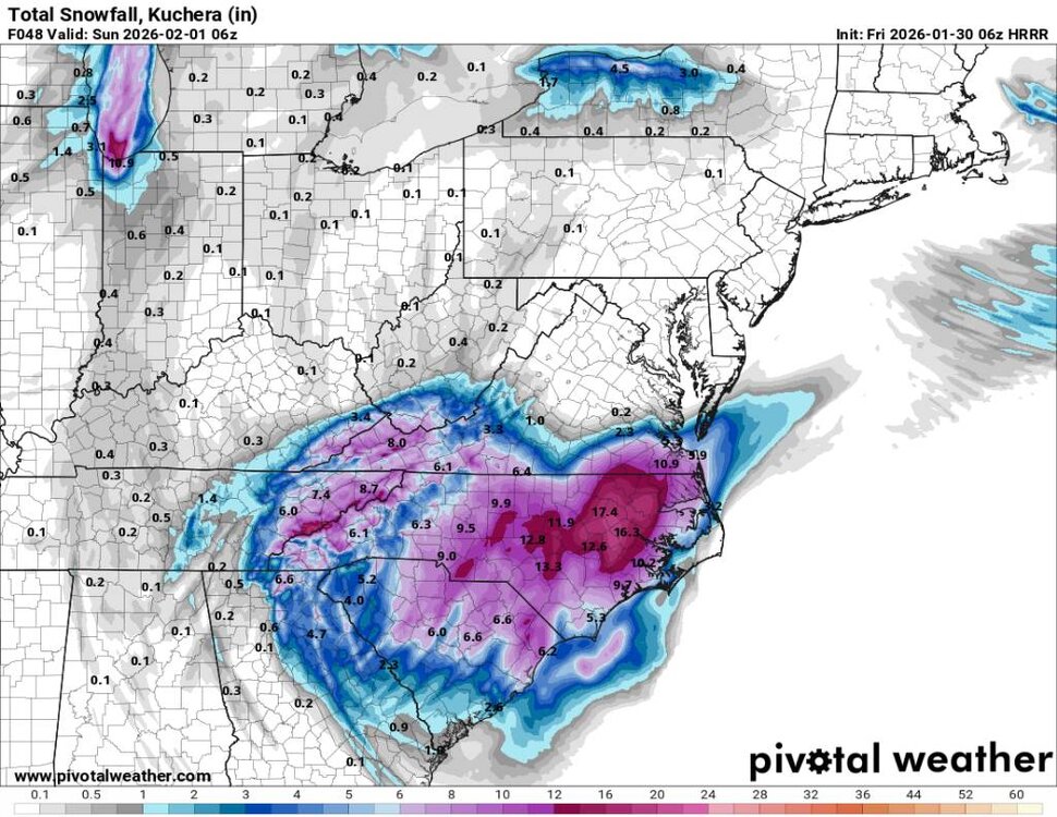
A great run by the 12z gfs and along the border counties I think we see flow snow until Sunday morning. I think the models are cutting the flow off too soon. But a great run in general. Sent from my SM-G998U using Tapatalk

-
12z gfs Sent from my SM-G998U using Tapatalk
.thumb.jpg.3fc6e59a4ec320cd41be2b975b5606e0.jpg)
-
12z gfs is coming in hot. Showing first precipitation starting at around 3 this afternoon now and continuing through the the evening and building.
-
Buncombe county 2 hour early dismissal.
-
Yeah looks like snow may start sooner than later. Haywood county superintendent does a great job heading stuff off also.
-
12z HRRR isn't as juiced. Looks decent still but is this just noise or a trend? I'm still riding with the Euro. Sent from my SM-G998U using Tapatalk
.thumb.jpg.57c149abeb0612b554c5548d24586482.jpg)
-
Yeah this will start showing up towards the end of February.
-
I think a lot of people have Helen PTSD. I think thats why everyone went crazy at the grocery stores last week.
-
06z HRRR looks solid as well. I think it may have done a bit better than other short range models last weekend besides the thermals. Sent from my SM-G998U using Tapatalk
-
Euro has been steady for days.
-
The NAM has been crap in my opinion.
-
Definitely going to be a dry snow but you may have to worry about the wind Saturday afternoon.
-
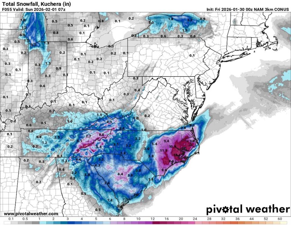
The regular NAM but I don't trust it. Honestly riding the EURO. it's been very consistent the past few days. Sent from my SM-G998U using Tapatalk
.thumb.jpg.d401ea903d987802a9f7a0880a788550.jpg)
-
The NAM 3K looks decent . Sent from my SM-G998U using Tapatalk
-
NAM 3K looking good tonight. Seems like the favorable areas along the border will start snowing tomorrow anywhere from 2 to 4 tomorrow and then the other counties will start 7 to 9 tomorrow night and according to the NAM 3k their will be a heavy band of snow coming through around 5 or 6 in the morning then continue to snow through the day.
-
Gfs looking to be another great run.
-
Yup, same here which I'm looking for some higher amounts honestly. Saturday and Sunday the highs are going to be in the teens. Sunday mornings low looks to be negative 2 degrees and Monday morning looks to be about 3 degrees.
-
Yeah tomorrow evening fellas.
-
Yeah this weekend is going to be wild.
-
Dang @Buckethead! You just beat me by a minute lol.
-
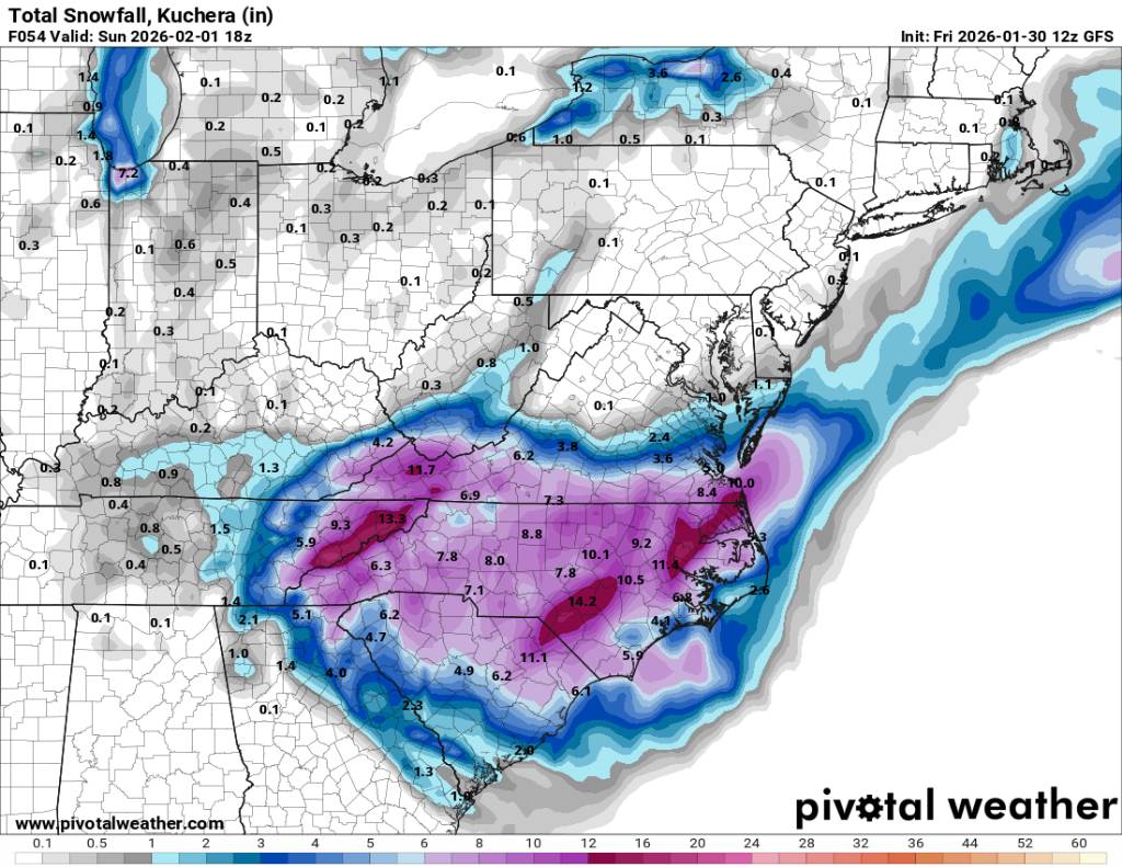
Hard to go against the Euro. Pretty much putting us in the bullseye of this thing. Frozen ground, arctic high, heavy snow, and windy. Has all the recipes for short term blizzard conditions and whiteout conditions around the mountains this weekend.
-
Anyone have the map of this mornings euro run.
-
Conservative but I understand that is best for the public. Better to bust high than low.
-
Thank you. I really like how we are sitting with this.
-
Looks like everything is a go with the overnight models. This morning NAM looked wonky but the gfs looked good except for the shadow over Buncombe county but the more west the low forms the better our moisture will be from the East. The border counties have no problem at all. Forcing and moisture will be abundant. Honestly I don't think GSP is really catching that but a foot plus along the border. I'd go with a general 5 to 10 inches closer to the border and a general 4 to 8 inches away here in the mountains. Heck 4 inches is still a heck of a storm that most haven't seen in years and back to back winter weather events is awesome! Not to mention the Euro suddenly is showing something else for next Thursday.... So we are off to the races.


.jpg.765100952429a98bbde076248a2d819c.jpg)
.jpg.4ddcc1d0e8c93426be0d851dc62b42a7.jpg)

.jpg.ca669752ad2c9b5daafd576f98b3d12b.jpg)
