Nelson
-
Posts
565 -
Joined
-
Last visited
Content Type
Profiles
Blogs
Forums
American Weather
Media Demo
Store
Gallery
Everything posted by Nelson
-
FXUS63 KMKX 082150 AFDMKX Area Forecast Discussion National Weather Service Milwaukee/Sullivan WI 350 PM CST Thu Dec 8 2022 .SHORT TERM... (Issued 350 PM CST Thu Dec 8 2022) Tonight through Friday night: The main forecast changes: 1) delayed the arrival of snowfall across east-central Wisconsin where drier air will put up a fight, 2) shifted the main axis of snow about 50 to 100 miles south, 3) expanded the Winter Weather Advisory to the south and east, and 4) used 10th-90th percentile for snowfall totals online. More details below! The main focus tonight through Friday night is on the banded area of moderate to heavy snow expected to lift through southern Wisconsin late tonight through approximately mid-day Friday. While the wave is deamplifying as it approaches the area, there is still an overabundance of large scale ascent moving through the area. With WAA nosing in ahead of the shortwave, a transient area of 850-700mb frontogenesis also sharpens across the area, bringing a more focused area for localized ascent. The 12Z HREF does show the potential (20-40% chance) we could see some embedded areas within the band where snowfall rates could approach 1 inch per hour. Thus, as the this band moves through expect snowfall rates to pick up and visibilities to become sharply reduced. Opted to go with 10th-90th percentile for snowfall, as it handled the uncertainty across our northern counties and lakeshore counties well, while adding in some potential for locally higher amounts where the banded area of snowfall tracks. Where does this band track? Well, it will be highly dependent on how the drier air currently over the region and upstream of the area holds on. High-res models really limit the higher QPF and snowfall potential across Marquette/Green Lake and portions of east-central Wisconsin given the easterly winds advecting in drier air from the southern extent of high pressure up near the Hudson Bay. This drier mid-level air was sampled well by the 12z soundings from KAPX and KDTX. Thus, the latest RAP/HRRR keep the better chances for accumulating snow within the banded feature roughly along and south of I-90/I-94. Whereas the NAM/GFS do continue to show some potential for better QPF and snowfall up into central Wisconsin. Thus, did keep the original Winter Weather Advisory as is, and added counties to the south and southeast to account for the shift to the southeast with the high- res guidance. As for p-types, we could still see some freezing rain develop ahead of the banded area of snow late tonight. As the mid-level dry air erodes, soundings do show some potential for temperature aloft to remain above freezing briefly while surface temperatures hover around freezing. The NBM v4.1 probabilities support the potential for freezing rain early on, thus have continued to include mentions in the forecast. Otherwise, once the band of snow moves in, even along Lake Michigan, dynamical cooling and robust forcing along the band of frontogenesis will help keep precipitation in the form of snow. Due to the pronounced lift, did run the weather type forecast using surface wet-bulb temperatures of 35 for the cutoff for snow mentions. As easterly winds continue throughout the day and temperatures warm near Lake Michigan, this will help favor a transition over to rain/snow or rain during the afternoon hours. Then as the banded area of snow moves east, exiting over Lake Michigan and weakening, we will lose cloud ice and should see a transition over to drizzle or freezing drizzle. Surface temperatures will be critical Friday night into Saturday, as freezing drizzle may linger and lead to some impacts given the lingering 850mb WAA stream up into the area. Anderson
-
2022 Short/Medium Range Severe Weather Discussion
Nelson replied to Chicago Storm's topic in Lakes/Ohio Valley
Crickets . -
4.9" here west of Madison. Overachiever. edit: sorry, 4.875
- 143 replies
-
- 13
-

-

-
F*ing Bucky (of course, been playing to the level of their competition all year) blew it against NEB - otherwise we aren’t having this conversation .
-
19F and thundersleet/snow to the west of Madison.
-
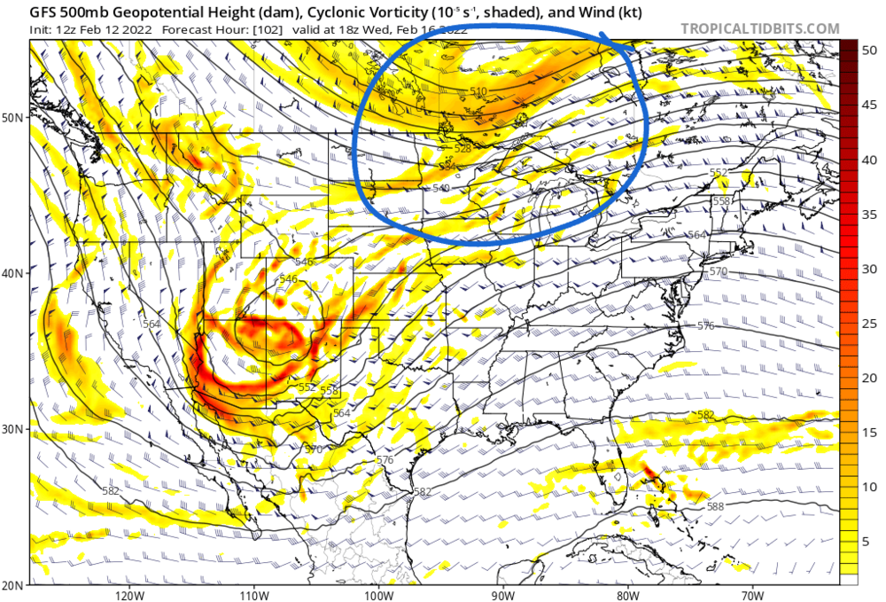
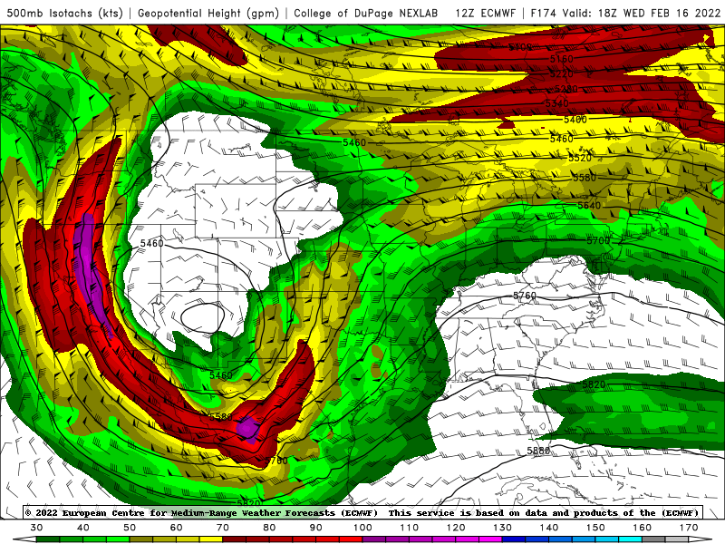
Fairly decent consistency on the GFS ens. Of course, we saw this movie last time so not getting too invested. Euro still onboard for late week potential.
-
Did I get the northern stream energy right and the fact that it's trending slower/deeper?
-
Curious/trying to learn a little bit. Both the GFS/Euro seem to be trending slower/deeper with the northern stream piece of energy. What impact does that potentially have? Favor a better chance of phasing, thus a stronger (possibly negative tilt system)? Or something else? Or am I completely not looking at this correctly?

-
I would argue that the GEM stayed somewhat similar to 0Z though it's SLP representation is different at 12Z. GFS has largely been unchanged over the past 3 runs. Euro had a noticeable shift south with the SLP placement at 12z compared to 0z.
-
^^ It's all we got this year....
-
Winter 2021-22 Short/Medium Range Discussion
Nelson replied to Chicago Storm's topic in Lakes/Ohio Valley
Yeah, definitely not wrapped. However, still remain cautiously optimistic about a season best snowfall for parts up this way. Like the GFS/Euro consistency with something happening in the middle of the country. Still a little far out to get excited though.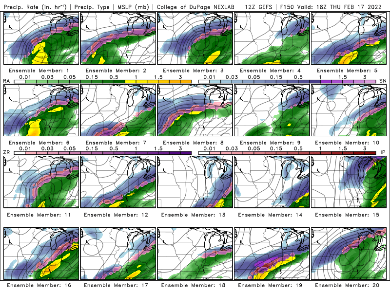
-
Winter 2021-22 Short/Medium Range Discussion
Nelson replied to Chicago Storm's topic in Lakes/Ohio Valley
Cautiously optimistic for the 17th-18th time frame. At least for the west/NW portions of the sub. Quite frankly, I would welcome the rain just to see some f'ing precip.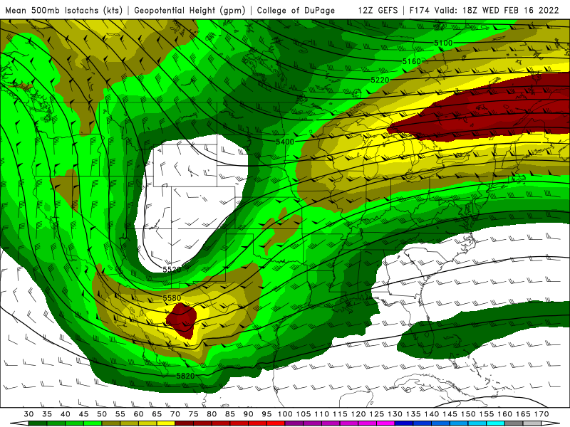
-
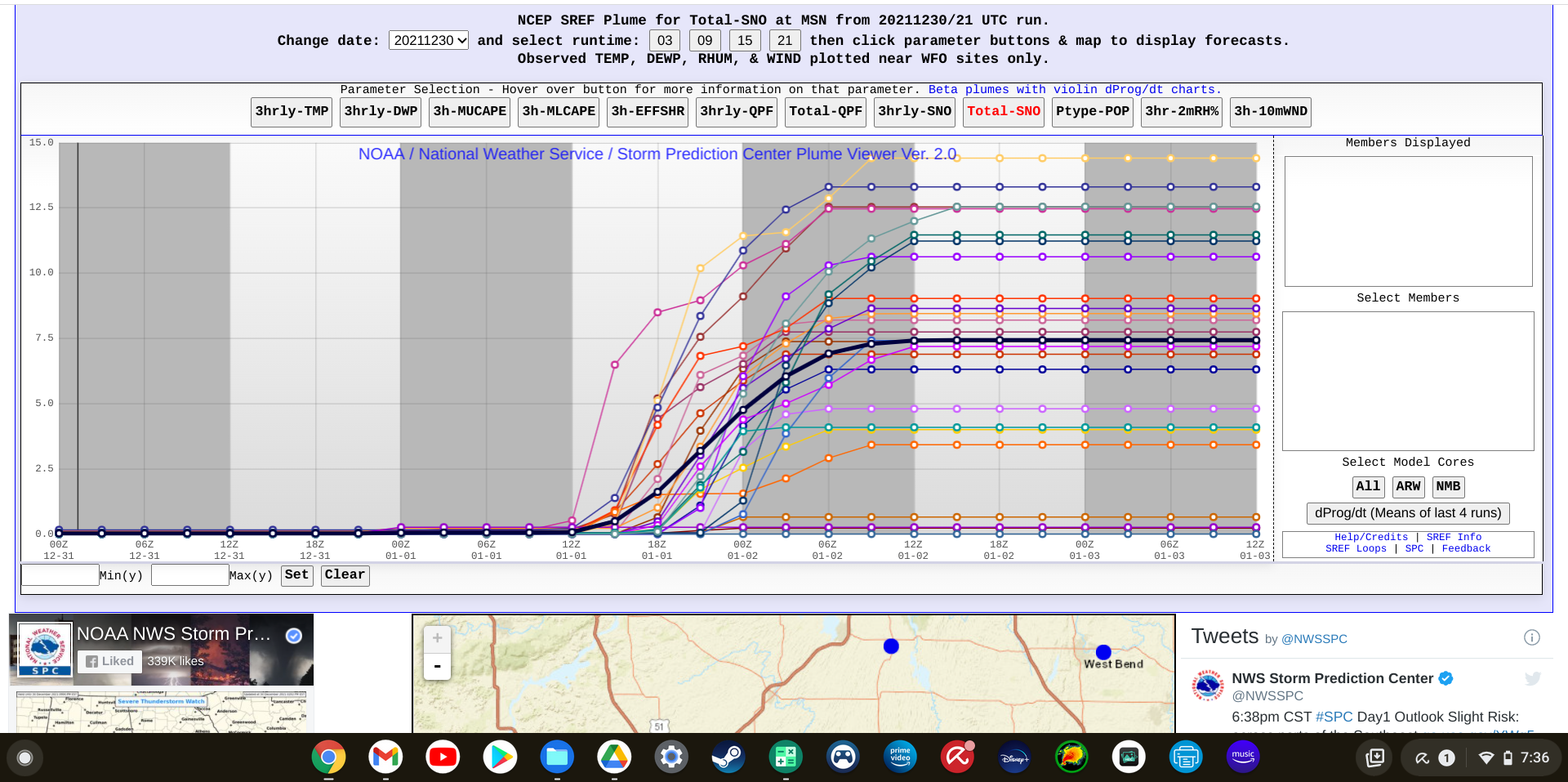
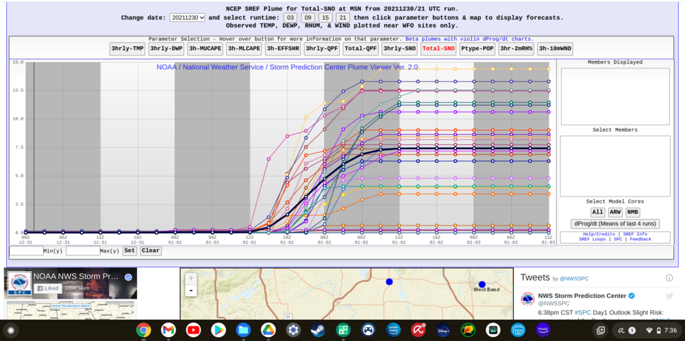
I will take whatever SREF is smoking for MSN (grasping at straws on the northern fringe)
-
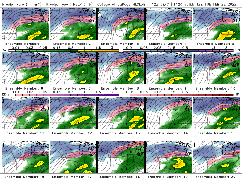
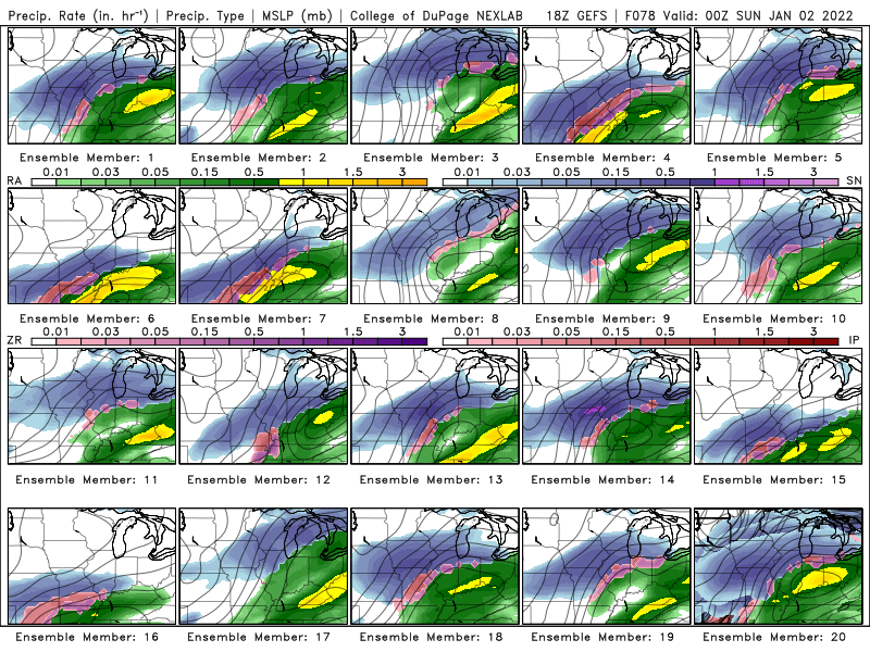
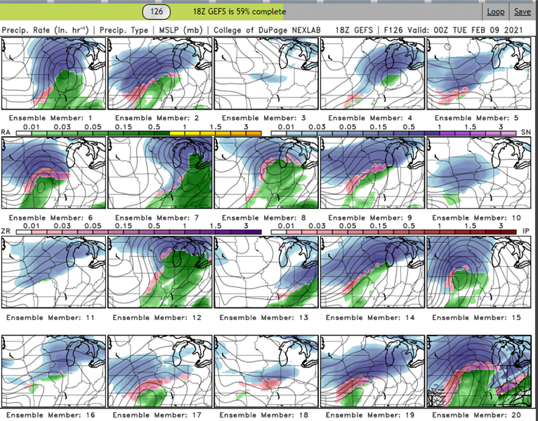
18z GEFS members. Starting to get some consistency among the individual members. CHI/N IL/E IA starting to look pretty good.
-
Winter 2021-22 Short/Medium Range Discussion
Nelson replied to Chicago Storm's topic in Lakes/Ohio Valley
buuuut, for historical purposes, here are the last two runs of the GFS.
-
Winter 2021-22 Short/Medium Range Discussion
Nelson replied to Chicago Storm's topic in Lakes/Ohio Valley
No concerns with run to run differences at this point. The point is that both GFS and Euro show the trough in the same time frame. Whether it cuts through MN or MI on a specific run isn't important right now. -
Winter 2021-22 Short/Medium Range Discussion
Nelson replied to Chicago Storm's topic in Lakes/Ohio Valley
It's a nice look - hopefully it's got some legs...
-
Winter 2021-22 Short/Medium Range Discussion
Nelson replied to Chicago Storm's topic in Lakes/Ohio Valley
I miss the medium range pattern discussions - where did all of those folks go? -
Damn, sorry to hear about the loss of your son. As a father, it's hard to imagine having to endure something like that so I hope you and your family can find some peace through all of it.
-
Feels like it's been a while since we've had a legit ROF set up. NW flow never going away though..... ever
-
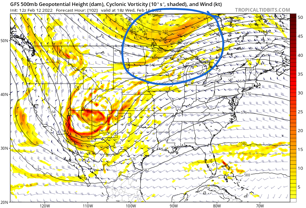
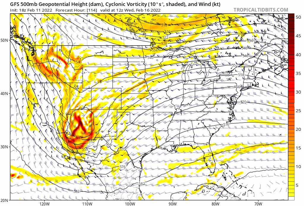
Feb 12-14th V-Day Weekend Potential Stuff
Nelson replied to Chicago Storm's topic in Lakes/Ohio Valley
MKX definitely been hit or miss with the AFDs as of late. I think Wood (if I'm recalling the name correctly) typically does a good job with the write ups. Sorry for the OT -
4.1" here. Maybe another .1 or so with some real light returns for the next hour. Pretty much right where I thought we would end up. Cool event overall. Really poured for a few hours.
-
32.5F and +SN. Decent winds out of the SE. Gonna stack nicely if this keeps up for a few more hours.
-
It's a good start.
-
Somewhat of an odd storm evolution - if you simply looked at the SLP track, it looks like a classic mid-west snowstorm but surface features don't really play out that way (looks more like a glorified frontal passage). Much like the last storm, models have been fairly consistent with roughly .5 qpf for mby. I think 3-5" looks like a good call.