Nelson
-
Posts
565 -
Joined
-
Last visited
Content Type
Profiles
Blogs
Forums
American Weather
Media Demo
Store
Gallery
Everything posted by Nelson
-
That's how trolls be...
-
Absolutely, I think we were at about 2" before that band set up. I didn't get a chance to take proper measurement here but I would say were right around 7". Definitely exceeded expectations for mby. Bigger totals just south and east of here.
-
Moderate to heavy snow for several hours west of Madison. Very fluffy - have not had a chance to measure but have to around 4-5” .
-
Winter 2022/23 Medium/Long Range Discussion
Nelson replied to Chicago Storm's topic in Lakes/Ohio Valley
Yeah, like the look of this if it can hold. Feels like that should produce somewhere.
-
Jan 19-20: Hoosier is not allowed to start this thread
Nelson replied to mimillman's topic in Lakes/Ohio Valley
Southern Wisco is here but as madwx mentioned we are riding a razors edge with this one. We need to find Daddylonglegs and get that LaCrosse perspective. -
Winter 2022/23 Short/Medium Range Discussion
Nelson replied to Chicago Storm's topic in Lakes/Ohio Valley
Someone will correct me but I think the large scale pattern is a little different than the pre-christmas storm so probably not fair to compare the model performance. -
Winter 2022/23 Short/Medium Range Discussion
Nelson replied to Chicago Storm's topic in Lakes/Ohio Valley
stop it ^
-
Winter 2022/23 Short/Medium Range Discussion
Nelson replied to Chicago Storm's topic in Lakes/Ohio Valley
Meanwhile...
-
Winter 2022/23 Short/Medium Range Discussion
Nelson replied to Chicago Storm's topic in Lakes/Ohio Valley
What a difference a day makes..........
-
Winter 2022/23 Short/Medium Range Discussion
Nelson replied to Chicago Storm's topic in Lakes/Ohio Valley
Euro has been pretty consistent with that system for the last several major runs - actually came NW a little with the overnight suite. GFS has been bouncing on either side of it. EPS has been fairly consistent as well. All that said, I'm not buying shit until Sunday or Monday.
-
But I feel like you're reformed and have started down a more righteous path... That said, you're right, the cold should be the focus. -4F currently - didn't crack 0 today.
-
Don't feed the trolls man...
-
Pre-Christmas (Dec 21-23rd) Winter Storm Part 2
Nelson replied to Chicago Storm's topic in Lakes/Ohio Valley
Sorry...
-
Pre-Christmas (Dec 21-23rd) Winter Storm Part 2
Nelson replied to Chicago Storm's topic in Lakes/Ohio Valley
Agreed - should see some decent ratios before the front blasts through tomorrow. Not the big dog we wanted but should be a snowy mess nonetheless. -
Pre-Christmas (Dec 21-23rd) Winter Storm Part 2
Nelson replied to Chicago Storm's topic in Lakes/Ohio Valley
Very light snow falling here west of Madison. -
Pre-Christmas (Dec 21-23rd) Winter Storm Part 2
Nelson replied to Chicago Storm's topic in Lakes/Ohio Valley
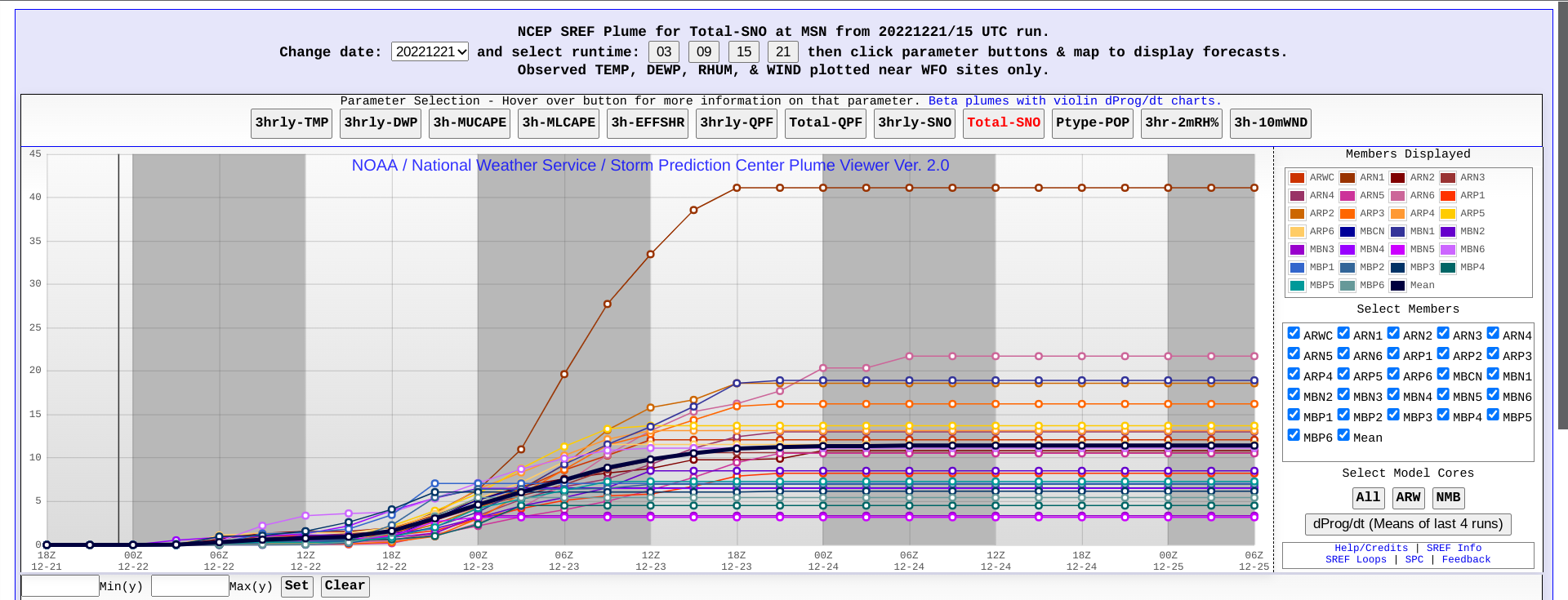
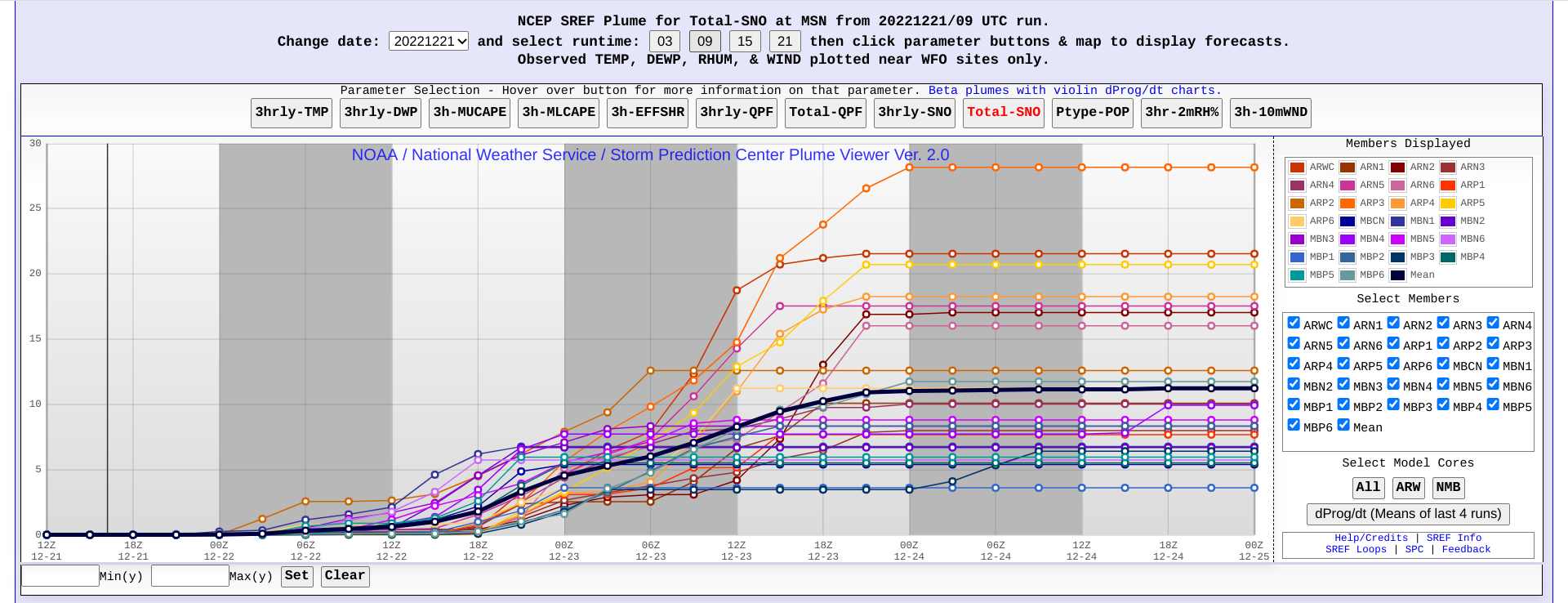
SREF or die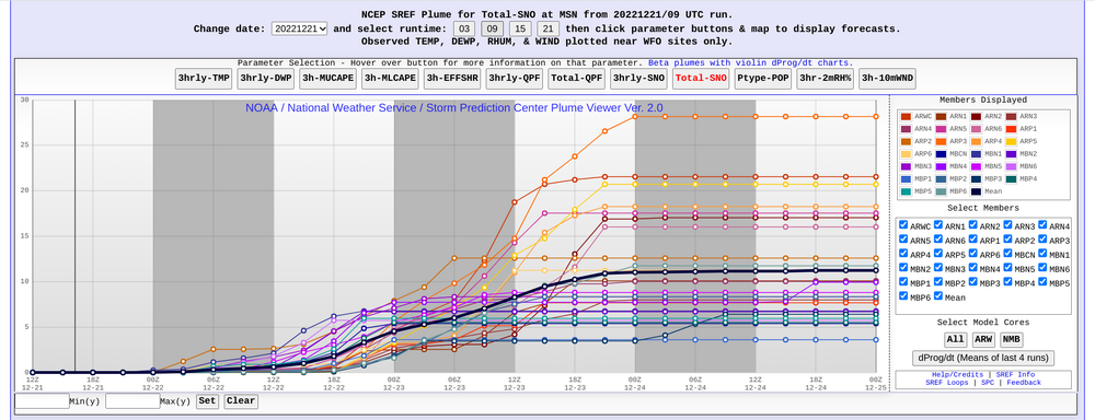
-
Pre-Christmas (Dec 21-23rd) Winter Storm Part 2
Nelson replied to Chicago Storm's topic in Lakes/Ohio Valley
I’m liking 6-8” for Madison. Should see higher ratios with mostly a front end bump vs wrap around. Throw in some winds on Friday and it will be as wintery as anyone could ask for. . -
Pre-Christmas (Dec 21-23rd) Winter Storm
Nelson replied to Chicago Storm's topic in Lakes/Ohio Valley
FXUS63 KMKX 192135 AFDMKX Area Forecast Discussion National Weather Service Milwaukee/Sullivan WI 335 PM CST Mon Dec 19 2022 .LONG TERM... (Issued 335 PM CST Mon Dec 19 2022) Wednesday through Monday: Confidence continues to increase in a potent winter storm later this week that could bring blizzard conditions to southern Wisconsin. There is high probability for significant winter impacts in the region, with the focus now on narrowing down the timing and location for the most impactful weather. This storm will have ample moisture and forcing for significant snowfall, with confidence increasing for 6+ inches. Latest model ensemble snow probabilities show the higher end numbers right across the forecast area. This is not surprising, as latest guidance shifted a bit back towards the southeast with the low track, knocking out any mixed precip or rain potential in the southeast that was showing up earlier. Ensemble probabilities are on the high end for wind gusts of 40-50 mph during the height of the storm later Thursday into Friday night. Some guidance is showing the potential for gusts to 60 mph, though not ready to bite on these higher numbers yet. Given the potential for this storm to have high end impacts, decided to pull the trigger on a Winter Storm Watch Thursday through Friday night. Warm advection aloft ahead of the storm will likely result in the snow starting by Wednesday evening, but the worst of the weather is expected to hold off until Thursday. There is still a lot of time for the track/timing of this storm to change. When/where the low deepens and the track of the low will likely continue to waffle a bit from model run to model run, so keep up with the latest forecast as the finer details will continue to be worked out. Another concern with the late week system will be the cold wind chills on the back side of the storm, with 15 to 25 below possible later Friday into Friday night. -
Pre-Christmas (Dec 21-23rd) Winter Storm
Nelson replied to Chicago Storm's topic in Lakes/Ohio Valley
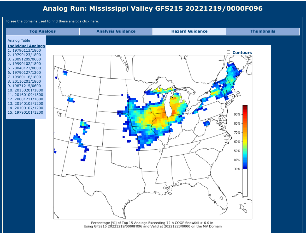
0Z CIPS. Decent list.....
-
Snagged 3.9” .
-
Winter 2022/23 Medium/Long Range Discussion
Nelson replied to Chicago Storm's topic in Lakes/Ohio Valley
point proven -
Winter 2022/23 Medium/Long Range Discussion
Nelson replied to Chicago Storm's topic in Lakes/Ohio Valley
Accounts are based on email so people can keep making accounts and coming back as much as they are willing to create new email accounts. There really isn't anything you can do other than to keep banning them once you figure it out. The dopamine effect of getting people to react to your comments is just too much for some folks to resist. I probably shouldn't have acknowledge the comments but frustration got the best of me. -
Winter 2022/23 Medium/Long Range Discussion
Nelson replied to Chicago Storm's topic in Lakes/Ohio Valley
I know he is - just felt like I needed to say something given that we don't have a mod. Not that a mod is necessarily going to do anything. If they need to get their kicks trolling a weather board, they are going to find a way. -
Winter 2022/23 Medium/Long Range Discussion
Nelson replied to Chicago Storm's topic in Lakes/Ohio Valley
What's miserable is coming into these threads and having to endure your comments, sarcastic or not. Also, by responding, I understand that I'm giving you exactly what you're looking for... -
Why do you post here?