

RogueWaves
-
Posts
2,559 -
Joined
-
Last visited
Content Type
Profiles
Blogs
Forums
American Weather
Media Demo
Store
Gallery
Everything posted by RogueWaves
-
DTW's coldest high since the 1st. Currently in the 30s with a WC below freezing as a system heads this way. I'm fine with this for November. This is better than a premature snowstorm like say 11-11-19. If it's going to be split-flow, aka S Stream dominant then we just need it a bit colder than last winter which basically featured that same Nino styled pattern. A repeating theme has been these cold pools of air just NE of here (where it is currently in the 20s) feeding into this region. Not ideal, but work-able imo.
-

Winter 2023-24 Longrange Discussion
RogueWaves replied to michsnowfreak's topic in Lakes/Ohio Valley
Recent systems (except sneaky one on 11/8) have all fizzled out as they came this way, fwiw. I am watching this Tue-Wed S Stream system in hopes it actually has legs and doesn't crap-out. Would boost my hopes for winter a bit. -
Fall 2023 Medium/Long Range Discussion
RogueWaves replied to Chicago Storm's topic in Lakes/Ohio Valley
Yesterday, all 3 globals were going for the mega-phase (I guess Ukie wasn't up for the ride) though so it seems that they were seeing something favorable for that outcome. Are the models just bad in unison or are they wired to lean towards any potential high-impact scenario on behalf of Joe Public's safety? Legit asking if you have any intel in that regard since I have often wondered why they go that route many times and it almost always unravels in the end. -
Winter 2023-24 Longrange Discussion
RogueWaves replied to michsnowfreak's topic in Lakes/Ohio Valley
I did. Look closer, the 4.2" was my largest single day total. Early February was 5.6" for two days. The 17th was just 4" and there are other reports and maps to back up those sad numbers here. Thx for the reminder tho. -
Winter 2023-24 Longrange Discussion
RogueWaves replied to michsnowfreak's topic in Lakes/Ohio Valley
21-22 gave us back-to-back clipper hits twice. In late November and later January as well. Nov 27th was actually my largest single day amount the entire winter at 4.2". The clippers were far and away the better systems for me that winter from a forecast to verify perspective. -
Fall 2023 Medium/Long Range Discussion
RogueWaves replied to Chicago Storm's topic in Lakes/Ohio Valley
Some wind and perhaps mood flakes for the rest of us outside the belts. A month later, and I might get lucky like last Christmas day. -
Fall 2023 Medium/Long Range Discussion
RogueWaves replied to Chicago Storm's topic in Lakes/Ohio Valley
Did that my first year in NWMI. Apparently the poor tree was in hibernation mode and coming into my warm living room was fooled into "false spring". The main leader grew 12" and was curling off my ceiling. After that, I never did it again. -
SEMI the only ones experiencing these extreme temp swings? AA with a 42 degree flip today, beating yesterday's 31 degree delta.
-
12z Euro trying to make the holiday week much less boring in the wx dept
.gif.696b373e388ee9c20d30735d1d667c22.gif)
-
For sure. He said it was "first time in history" when he would've been more correct to say in our brief recorded history of the weather/climo. Quite certain the period I mention had much warmer temps during that era when Europeans were able to colonize Iceland for a few hundred years before the climate pendulum swung back the other way and headed into the little ice age.
-
Medieval warm period says "hold my palm tree"
-
Fall 2023 Medium/Long Range Discussion
RogueWaves replied to Chicago Storm's topic in Lakes/Ohio Valley
I believe the week after Thanksgiving has the better potential. But we'll let the models continue to sort things out as usual. -
What? That I can enjoy more boat-n-beach days, and fewer sled-n-ski days? Did I miss something? What's the scary reality in that? Summers of 13/14/15 were horrible. Could hardly find a decent day to enjoy our wonderful GL's. I fail to see any "wow factor" in the drum you continually beat. And I'm a gardener at heart, so I appreciate your hobby and how much effort you put into that awesome tropical look. I just see a lot of wishful thinking that FL climo is suddenly going to pounce on yby without a sudden shift of the poles - that's actually a much scarier prospect tbh. Now back to looking at the impending cold December on tap..
-
So, its milder right at water's edge - shocking! I used to live there, just 1 block off the beach. Even if that avg has creeped up, what does this mean in reality? I could now put a sensitive plant or palm out and about every 3-4 winters it will fail to survive the inevitable arctic cold wave. What's the point in that? Really?
-
Fall 2023 Medium/Long Range Discussion
RogueWaves replied to Chicago Storm's topic in Lakes/Ohio Valley
Agree. Wouldn't be counting on clippers, but moreso some hybrids as we had in the last Nino 18-19. Main player likely STJ this winter. IF we could manage to get in the crosshairs of both tracks, that would be huge. -
Fall 2023 Medium/Long Range Discussion
RogueWaves replied to Chicago Storm's topic in Lakes/Ohio Valley
Taking 14-15 again, Dec 14 was about as "non-winter" as you can get. Whereas Feb 15 was about as "severe winter" as it gets around SEMI. January, at least where I was in SWMI was a mixed bag but leaned colder with slightly AN snowfall, including a warned event. I do get your point ofc, everyone looking for snow is not excited for a pattern that is 60-70% CAD. Mild and dry is much better like our current pattern. Even if we did split it 50/50, I much prefer that the cold and moist periods last for weeks (Feb 15) vs just days. Exception to that rule being 07-08 which we lucked out with a mega-active pattern for SMI. -
Fall 2023 Medium/Long Range Discussion
RogueWaves replied to Chicago Storm's topic in Lakes/Ohio Valley
I'm thinking we see this during winter. One common analog went this back-n-forth route (14-15). Someone posted on '89. It also did the back-n-forth. It made for some very dynamic systems too, if you were lucky enough to be in the right place. NMI in that case. SMI in the case of 14-15. -
Winter 2023-24 Longrange Discussion
RogueWaves replied to michsnowfreak's topic in Lakes/Ohio Valley
MJO liking colder phases. It's the "D" in CAD that remains to be seen. -
It's called the rut
-
Winter 2023-24 Longrange Discussion
RogueWaves replied to michsnowfreak's topic in Lakes/Ohio Valley
I don't think you have to sweat it. Was there ever a year without winter up there? -
Fall 2023 Medium/Long Range Discussion
RogueWaves replied to Chicago Storm's topic in Lakes/Ohio Valley
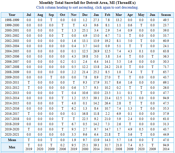
Iiuc, '98-99 broke the dismal streak of low-snowfall winters for DTW during the '90s. Looking at the next (23) winters, on average we can hit dbl-digit snow depth roughly every 2.3 yrs: And score a noticeably AN snow fall season approximately every 2.9 years: Obviously, I left out the last pair of winters that failed to reach either category threshold. They can be put towards the next AN winter lol. What I'd like to think is that based on the averages we might be due a better winter.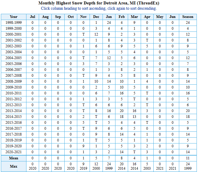
-
Fall 2023 Medium/Long Range Discussion
RogueWaves replied to Chicago Storm's topic in Lakes/Ohio Valley
Yeah, I guess he did say "snow" not snowstorm. My bad. -
Fall 2023 Medium/Long Range Discussion
RogueWaves replied to Chicago Storm's topic in Lakes/Ohio Valley
Wasn't 07. As for T-day 08 that was on the 27th and there was the storm a few days later that straddled 11/30-12/1 (I was in downtown Chicago where it was mostly RN) which left a decent blanket of snowcover to start the rockin' month of December. Perhaps that's what you remembered. It was Sun/Mon of T-day weekend.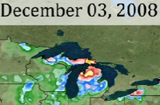
-
In years when there was ample snow by 11/15, I never rode my sleds until after dark. Partly out of courtesy, partly not to piss-off someone holding a high-powered weapon, lol. @weatherbo My late cousin had a hunting cottage near L'anse. I never made the trek all the way up there to hunt so I didn't realize it was bucks only up there. Should be open season here in the burbs lol. Last year I had a 10 point and a 6 point run in front of my car just a 1/4 mile from here. Surprising amount of wildlife here in western Wayne County. A lot of waterways and greenways run between endless housing developments. One is on the south side of Plymouth. There's a huge Tom turkey that stakes out his claim to S Main and Ann Arbor Rd in front of a Chrysler dealership. Causes traffic snarls all the time.
-
Fall 2023 Medium/Long Range Discussion
RogueWaves replied to Chicago Storm's topic in Lakes/Ohio Valley
OMG yes! How did I not remember the 04 early storm. Was only 4-5" in Marshall but there were places up to a foot in SWMI. Another reason 04-05 rocked across SMI. (see my post in the winter thread for more hype). First event I remember in 07-08 was the mid-Dec system. Will have to check out whatever missed me earlier on.


