

WeatherMonger
-
Posts
644 -
Joined
Content Type
Profiles
Blogs
Forums
American Weather
Media Demo
Store
Gallery
Posts posted by WeatherMonger
-
-
5 minutes ago, Chicago Storm said:

.

-
3 hours ago, WeatherMonger said:
Ok all you OH peeps, stick to that promise you made earlier today. You know. The one you said you would trade the snowstorm for a Bengals Superbowl.....
Pay up...

Just an FYI, I blame those that made a sacrifice earlier for tonights runs should they continue this trend.....
-
 1
1
-
 1
1
-
-
2 minutes ago, Hoosier said:
I don't know... I'd be pretty nervous if I were on the southern edge.
The NW trend shall never be denied.
Pretty soon we'll start hearing those on the southern end talk about an over correction and it will come back south.
Never fails and rarely happens
Congrats Chicago et al, the force is strong with you effers
-
1
-
1
-
-
-
11 minutes ago, Chicago Storm said:
ancient eons ago.
Back then with winter storms about 7:15pm locally everyone started gathering around the proverbial campfire awaiting the NAM to start and hoped they could stay up throughout the 11:45 start of the Euro.
DGEX and Clown Maps were posted in the periods between.
The EE Rule was in full effect.
Good times
-
7
-
2
-
-
Reminiscing a bit about the GHD 1 event, trying to think back about trends and such as the imminent storm loomed.
Back then was on Accuwx forums and Chicago Storm and RobB would team up for the 0Z runs, CS giving the details and differences while Rob would post surface, 500 vort and 750mb images from the old NCEP site.
Forums would crash if it had a transfer to MA/NE region or impactful downstream otherwise as they overloaded the servers.
Wish that forum could have been archived before Jesse yanked the plug.
Anyhow, the north trends with this one, thus far anyway, don't seem to be as impactful IMBY yet. Remember one of the runs 3 days or so out back then Chicago Storm said Hour 51 more amped "central IL crushed". I thought it was a certainty here, then the north shift started and while I didn't do bad in the end, Chicago was the one that got crushed.
From that point on, outside of 36-48 hours I count on nothing.
-
8
-
-
7 minutes ago, Powerball said:
Isn't it SOP to issue Winter Storm Watches at least 48hrs before the onset of an event?
You guys (I'm talking about all the WFOs in line for some impact from this system) will definitely need to shit or get off the pot by tomorrow.
I was surprised ILX doesn't even have a HWO up.
-
2
-
-
Ok all you OH peeps, stick to that promise you made earlier today. You know. The one you said you would trade the snowstorm for a Bengals Superbowl.....
Pay up...
-
1
-
3
-
-
5 minutes ago, StormChaser4Life said:
Now that looks better. I'm super excited for you man. You're going to get

I'll know by Saturday
i've had my hopes crushed too many times, just hope the changeover happens fast.
Need the rain too though, have two 2 1/2' dirt mounds in the front yard from water line repair that need to settle.
-
1
-
-
Latest ILX graphic

-
2
-
-
Hourly wearher grod has 12.2" ATM, has .7" not shown through 5pm Fri.

-
1 hour ago, StormChaser4Life said:
Meanwhile WPC keeps shifting their highest probabilities for snow se. They might have to reverse that if trends continue. This seems a little too se imo
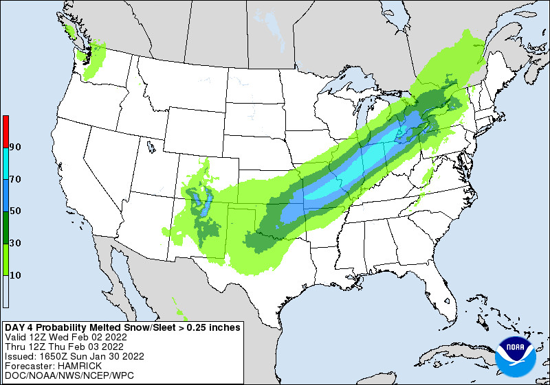
Their latest graphic.

-
3
-
-
I'd just lock the GFS in now please
-
14 minutes ago, StormChaser4Life said:
Well GFS seems to be on a lonely island right now. Even though it's been pretty consistent overall, would like to see support from other models.
I'll take 0Z NAM right here and now for a lock locally.
Have a feeling my hopes now will become your reality later.

-
10 minutes ago, BuffaloWeather said:
What qualifies as an official spotter if not Cocarahs or coop observer? Weather stations have nothing to do with snowfall measurements. I measured over the New York State record posted above in nov of 2014 as well under 24 hours.
A yellow card here in central IL

-
1
-
-
1 minute ago, fluoronium said:
It actually wasn't. That 36" in 24 hour snow total was in Astoria, IL in 1900. There must have been some tight banding with that system, since Peoria only received half of that.
https://www.ncdc.noaa.gov/extremes/scec/recordsI stand corrected, thanks for pointing that out. I couldn't imagine what it would take to get 2 feet here, let alone 3.
While I would like to experience it once, I don't believe I would want to twice.
-
2014, the year "Polar Vortex" became a media headline mainstay, fast forward 6-8 years and it's "Bomb Cyclone"
-
1
-
1
-
-
12 minutes ago, RogueWaves said:
Made me cringe when I saw both IL and IN higher than MI. WHAT??

Has to be a Chicago area lake effect event, here in Springfield our single 24 hour record is 17.4" from the Palm Sunday snow in 2013.
-
1
-
-
22 minutes ago, StormChaser4Life said:
I think you're sitting pretty for this. Because you get hit hard on the more northern GFS and the more southern Euro. Happy for you. I know you are long overdue. Just hope it isn't a complete miss here. I hope I can at least cash in nice on first round of overrunning precip but would be nice to get the main event wed into thurs as well like gfs has but not holding my breath. Ha
WPC's FB map from earlier on 4" snow and .1" ice accumulations has general l9cation good for both, or all 3 counting @Chambana. I was most surprised by the ice map, figured .1" would be easy for a longer stretch along the OV. I just don't want a sleet fest with the backside cold coming in. That would absolutely suck.

-
1
-
-
19 minutes ago, StormChaser4Life said:
Not surprised. By tomorrow it will have the snow shield on Gulf coast then up to Canadian border. It had today's nor'easter out to sea a few days out. Lol
I'm almost to the point of setting myself up for disappointment. I can't get excited yet, maybe Monday afternoon/evening but Ma Nature hates me. Did good GHD 1, but I just can't see Chicago not getting the best of it again. I remember when they got a T'storm warning and a 1" hail report with the thundersnow.
I'm thinking 6-10" will be a safe call here unless there is a significant NW shift which has happened many a times in NAM range, and we just got into the long range there.
Either way I'm sure we'll double our current season totals. Would only take 2.6" here....
-
2 minutes ago, StormChaser4Life said:
I miss accuweather forums. Those were the good ol' days. Lol
I feel for your area this winter. Horrible snow drought for most of Central IL into Central IN. The deformation zone of the low on Thurs could impact your area more than mine. Still days out. A lot can change. I72 gets way more severe wx action than here.
I'll give you the I-72 area sans Sangamon County
Up to 2.6" after uesterdays surprise .5" of snow.
So ready for Spring, but then I'm sure it will snow in April.
-
1
-
-
I say congrats to I-74 and north in IL.
Seems harder and harder to get that I-72 special in both Spring and Winter anymore here. Have already accepted rain showers for both thunderstorm and snow chances.
Still trying that reverse psychology that seems to work for some most of the time......
-
3 hours ago, Chicago Storm said:
what we really need is a moneyman return.
.I remember him from Accuweather forums
I just appreciated the fact he would post the Wx Bell Euro images when they were pay only.
-
1
-
-
Surprise 1/2" of snow here, 2nd best of this season


Feb 1-3rd GHD III Part 2
in Lakes/Ohio Valley
Posted
You can go ahead and do a temporary change to your profile pic.
You're Golden, trust me