

PDIII
-
Posts
1,403 -
Joined
-
Last visited
Content Type
Profiles
Blogs
Forums
American Weather
Media Demo
Store
Gallery
Posts posted by PDIII
-
-
18 minutes ago, Jebman said:
You're gonna get 6-9. You are very close to the Mason Dixon. Thats about 50 miles north of Baltimore.
And I am gonna hit up oregon ridge monday morning at 8:00 AM for sleigh riding with my kids!!! Thats in the same general area as mappy... I am thinking they should hit pay dirt.
-
1 minute ago, ers-wxman1 said:
This is clearly an event from I-81 to northern Loudoun and areas near and north of I-70 to the M/D line. 5-9 inch solid event is my call there.
I would be surprised to see 3-4” even out here in the Ashburn/Leesburg area. D.C. proper will be lucky to see 1”. South and east of there a dusting then rain.
I live a quarter mile from 70 but also a couple miles outside Baltimore City. I usually get caught in the screw zone for these type of events .. every once in a while my little but of elevation works in my favor. 5 inches is my benchmark.
-
3 minutes ago, psuhoffman said:
I was trying to be sub centered in that post. Not everyone is on a 1000 foot ridge on the northern edge of the region. What might prevent this from being a better result for more of the forum imo is the lack of true cold ahead of the wave. The track is workable if we had that. Might mix some but probably would still be a nice event into the cities. But with the stale marginal cold in place it creates a double bind for 95 south. More amped and waa easily presses warm layers into the region. Less amped and don’t get the dynamics needed to overcome the marginal surface temps. Places without any elevation are stuck in that double bind and walking a tightrope needed just enough amp to get a thump and not enough to press the whole mid level boundary north. A colder antecedent airmass would have solved that and gave all of us more upside here.
Yeah and that will keep the snow from sticking to the roads and will cause schools to be 2 hours late instead of off for Monday.
-
3 hours ago, leesburg 04 said:

That seems bullish to me. Good.
-
 2
2
-
-
17 minutes ago, C.A.P.E. said:
This would tend to favor some colder thermal profiles, however a more southern track may also lessen the dynamic forcing to some extent especially the farther northwest one goes.
they should have just said "thread the needle"..
-
3 minutes ago, leesburg 04 said:
Funny what happens when you let one storm finish before talking about trends or final solutions. I suspect today's runs will show true trends.
I hope. I am in Baltimore County so a slight south trend puts me the in bullseye. Seems like a legit wave.
-
4 minutes ago, jaydreb said:
Well congrats to you. Where are you at? Doesn’t look like anyone gets below freezing on sunday.
Baltimore.
-
1 minute ago, jaydreb said:
NAM says we will go from this cold rain to another cold rain.
No it doesn't. It is giving me 4 inches tonight and another five on Sunday and the storm ain't even done at that point.
-
Just now, MD Snow said:
Nam stronger with the LPC but south through 39hrs.
Well now that we are getting this Rainer out of the way, the models will have less interference and it will definitely be colder and more snowier
-
Looks like another wave around day 8
-
42 minutes ago, showmethesnow said:
Guess that the Euro didn't get the memo that the CMC was out to lunch with the Monday storm.

Oregon Ridge sledding special
-
1
-
-
1 minute ago, Subtropics said:
You live in Manchester. Completely different Climo from most of the subforum. Yes you can get snow up there. My lawn is already brown as dirt after 4'' the other day. In fact 10'' cooked off in about 2 days back in late January...
It was never that way before.. snow used to come and stick around for weeks. These days with the ice caps melting and all.. it doesnt have chance.
-
 1
1
-
-
Oh Ha.. nevermind.. you were talking about boxing the sport not the epic disaster of boxing day 2010... Lol
-
56 minutes ago, BristowWx said:
The Gerry Cooney thread....The Great White Hope! Many of us remember how that ended if you follow boxing and are old enough.
Boxing day was the psu Hoffman storm... I think...
-
4 minutes ago, leesburg 04 said:
These are the stat padding hours until any slop comes. Add that sh*t up now
Every meso has 6-8 hours or snow before the change over.. that's up here in Baltimore.. I would think maybe 4 more hours for you. Enough to lay down 4-6 imho
-
@showmethesnow @Ji and @Bob ChiII all disappeared at the same time. I am calling it.. its the same guy.
he is just talking to himself to fill up posts and content on the board.
-
15 minutes ago, NorthArlington101 said:
They do. I'm sure people are tired of me posting maps, so I'll just link you there instead:
-
14 minutes ago, NorthArlington101 said:
suspect
-
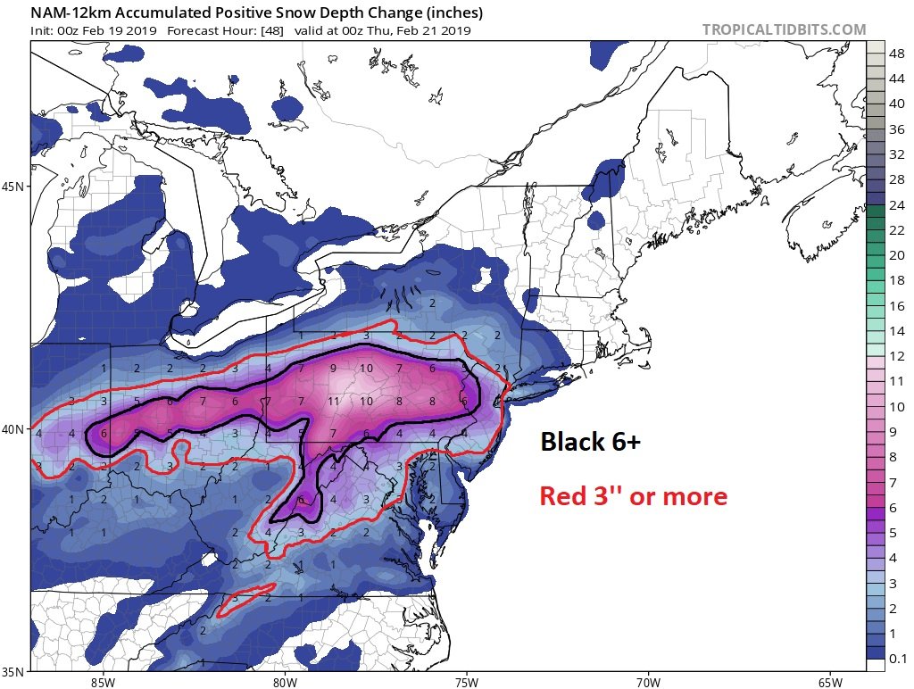
1 minute ago, Snowchaser said:
closer view of the 00z NAM Snow depth map
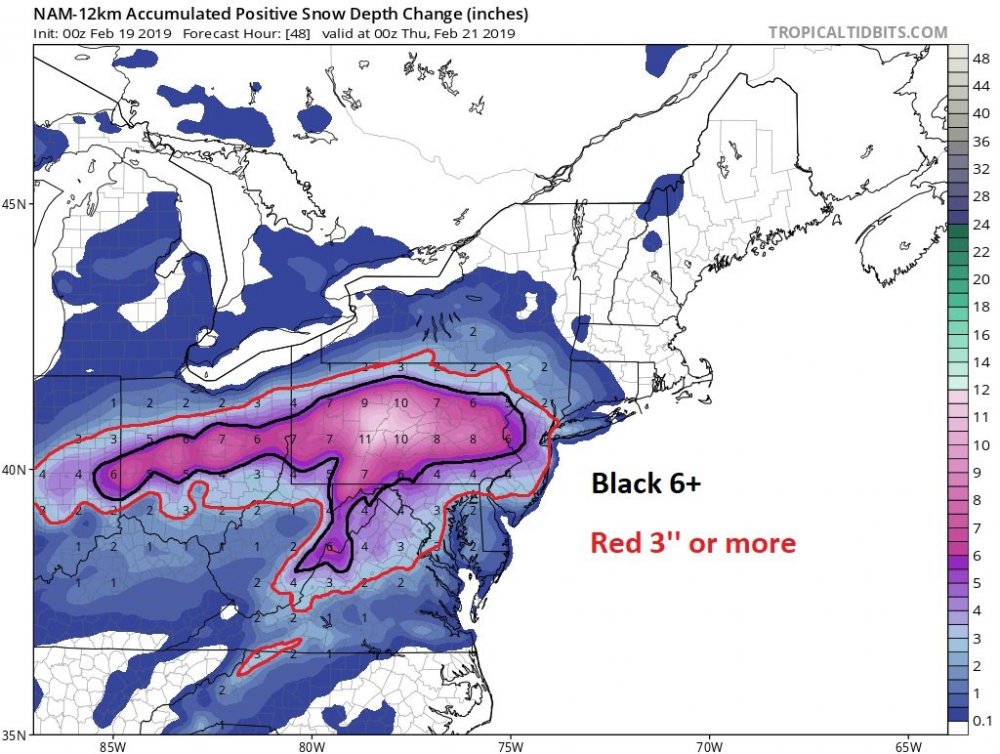
I would use the tropical tidbits total snowfall. It is much better
-
2
-
-
Just now, nw baltimore wx said:
The rates on President's Day 1979 were some of the highest I have ever experienced. Absolutely poured snow for hours. I also remember standing in the middle of my street during the 1983 blizzard when the skies lit up with lightning followed by an immediate crack of snow-muffled thunder. I almost crapped myself, but it was pouring dessert plates at the time. Those rates may have been even heavier than '79, but didn't last as long.
Actually I want to correct what I said above. I chased a lake effect event back in 2001 or 2002 where it snowed like 3 feet in like 10 hours... Tughill.. I passed out drunk when the it wents nuts... But I remember waking up the next morning thinking.. Jesus.. there was like only 6 inches on the ground when I passed out.. wtf?
-
1
-
2
-
-
7 minutes ago, Scraff said:
Finally able to catch up in here. Question—4” an hour rates!? Where is that possible? DC? MD? And if possible, are we starting to run into some thundersnow potential?
No one is getting 4" inch an hour rates. That's Sierra Nevada powder keg stuff. I think the most I ever measured in an hour in my lifetime was 3 and that was once in 2010 and once in January 2011. I think Valentines Day 2015 may have came close.. but that was a frontal passage.. freak show event.
In terms of banding.. Check Mappy's post above. You really dont know where the deathband(s) will set up. Banding is going to be meso and we probably wont have a handle on it until some time tomorrow night or right before game time.
-
3
-
 1
1
-
-
36 minutes ago, ers-wxman1 said:
I’m telling you this is unfolding. Significant storm and evolving.
I saw went out on a limb earlier. you're right most mets are basically now casting these things now. It is a shame. Years of schooling.. years of watching these things unfold and they basically just color a map that blends the leading guidance the day before the storm. I mean Christ.. even Marty Bass will give his opinion... and he isnt even a anything..
-
2
-
1
-
-
snowing
-
4 minutes ago, snowmagnet said:
That’s pretty consistent among the members. Wow.
Yeah but I would hope it would be consistent. We are only a 36 out until game time.
-
2
-

March Banter 2019
in Mid Atlantic
Posted
Did someone really make him change his screen name??
I don't support the wall, generally because it really will not be effective and there are much better/ common sense ways to solve these problems.
But I don't know if it is right to make him change his screen name. I think we should just let people stand up for what they believe in unless they are offending someone else or outwardly injuring someone.
Just having it as his screen name, although probably a poor decision, wasn't really hurting anyone.