

PDIII
-
Posts
1,403 -
Joined
-
Last visited
Content Type
Profiles
Blogs
Forums
American Weather
Media Demo
Store
Gallery
Posts posted by PDIII
-
-
32 minutes ago, osfan24 said:
It's also like a mere 30-40 mile bump to get almost everyone south of Baltimore into warning level snow.
I can't wait for our advisories to be upgraded to warnings... I am going to NYC this weekend for work.. so I will miss this. But it is just as fun tracking.
-
 1
1
-
-
Euro is stronger and further north at 24 hours as compared with yesterdays 12Z
-
1 minute ago, leesburg 04 said:
I'm guessing its just a matter of creating the range envelope. Euro 3" top end other models 6ish
3-6" is the forecast unless you are CWG then its dusting to 8"
They need to cover their bases.
-
I like 4 to 6 for everyone from southern md up to Harford county. I think there is a lot of upside and boom potential for this storm. Great temps.. solid pressure gradient.. great slug of moisture incoming. I think we get it all from waa and maybe Wes or someone south gets a quick 3 -5 on top of it from the coastal.
This event is likely to surprise and pleaee
-
17 minutes ago, leesburg 04 said:
As models begin to converge and then fine tune as we are on the doorstep it sure does scream how we should view model runs a week out...
That said it's pretty awesome how the models can see that an event may happen from so far out.
I just went back and look at last weekends runs of the GFS. A bunch came pretty close to nailing it. Especially the 18z from Sunday
-
Just now, Scraff said:
The server may implode if happy hour GFS comes in strong. Fingers crossed...
If the server is gonna implode due to the traffic on this site then there is something wrong the underlying deployment architecture and application that drives this site. I write web application and APIs for a livings and regularly load test with thousands of concurrent requests against instances running on my mac book pro...
Lets say the GFS goes ape sh%t and drops 23 inches on DCA.. and 120 weenies upload the snow map within a one minute timeframe.. thats really not that big of a load.... I would love to rewrite this board and host on the amazon...-
1
-
 1
1
-
 2
2
-
-
5 minutes ago, JakkelWx said:
Are you saying that the temps here won't be as much as an issue than what the FV3 is showing? Snow seems to hate us across the chessy bay.
Refer to the people that know what they are talking about.. seriously.. I am just weenieing out here.. but from my experience.. watching these things play out over the years.. when you get High Pressure placement like that over SE Canada.. anything 1040+ (and I have seen some runs with 1050+).. it is typically gonna be a cold storm.. and it is the temp and pressure gradient result in more lift.. more dynamics.. more precip.. and if things break right.. you can cash in on high ratios
-
2
-
-
12 minutes ago, Bob Chill said:
I will say... seeing a 1040 in SE canada on the Fv3 makes me doubt any temp issues. It's possible if the shortwave amps up enough and drives through the tn valley but basic MA climo says we're good.
It looks really cold to me... When you see the 850 line down in the tidewater and precip over running up in to PA.. you know your in business...
-
4 minutes ago, mikem81 said:
Where is FV3 link?
Go to tropical tidbits.. it is under global
-
1
-
-
What I like about this run is the temp and pressure gradient over our region. BWI stays in the mid to upper 20s with 850s running way below zero C throughout the region.. 1040 high parked right where it needs to be with a low pressure along the coast.. that look is Sunday morning...
If this verifies, there could be a lot boom potential with this storm.
-
1 minute ago, snowmagnet said:
Something I started noticing back in ‘13-‘14 and then in ‘14-‘15, was that the Euro had a tendency to sniff out storms in the long range, lose them in the medium, and pick them back up in the short range. Just a casual observation.
Yup. I agree with this completely. It happens every storm. Like clockwork. By this time Thursday we will be looking at a warning level event area wide.
-
1
-
-

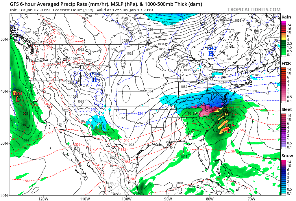
I know it is just the surface and as Bob pointed out H5 is leaving energy in SW.. but there is a lot to like here. Look at the precip field/ area of coverage. 1040+ high pressure. Rain snow line way down in Southern VA. This is what it looks like when get high ratio storms.
-
3 minutes ago, Rvarookie said:
I was speaking with Chuck earlier and we both agreed the cyclical nature of this really favors the same locations impacted on 12/10. I think dc folks may see few flakes...just enough to wet the whistle and leave folks dangling from the cliff.
Tell me more about the "Cyclical Nature".. I want to hear all about it.
-
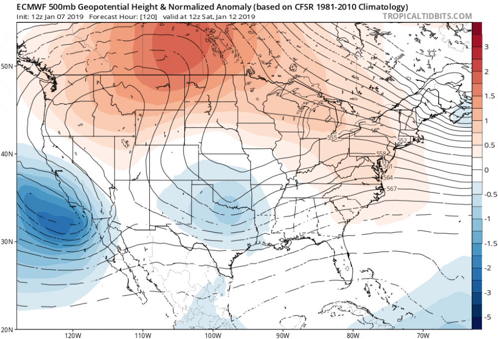
Looks better at 500MB at 120 than it did last run... maybe it is on to it?
-
Low pressure in to Chicago...
-
Shut... Out... Pattern...
-
Three to four degrees above normal is a pretty bold call... and it worked out!
-
Can someone copy and paste the contents of the article here so I can read it... Washington Post is making me pay and that is depressing.
-
3 hours ago, WxUSAF said:
We don’t talk about warm rain much?
With the track of the upper level cut off just to our south.. Looks like a rain to snow set up with crashing temps.. But then again if the euro showing all rain at the surface.. then I guess there is not enough cold air support a dynamic event..
The CMC and the Euro are showing this sort of track.. and to a certain extent so is the FV3... I feel like this might be something that sneaks up on us.
-
I can't believe that there is not one mention of the euro... Hmmm..
-
This is the time of the year the day 10 storm becomes the the day 9 storm and then becomes the day 10 storm again and every once in a while becomes the day 8 storm only to become the day 11 storm and disappear from the euro...
-
15 minutes ago, losetoa6 said:
Good way to ring in the New Year

Where's Ji?
Snowfall map?
-
still a lot if time to improve on this vort oassage

-
7 hours ago, Ji said:
GFS is a disaster
Yeah.. I just did my morning "tap, tap, tap, tap" through the GFS... hoping that something pops up in the long range... at this point the next 10 days seem fairly set.. maybe Wisp will get a quick 6 inches on the backside next weekend.. could be chase worthy if someone was really desperate...
Dynamic backend events are fun up there...
January 12-13th Cold Smoke Obs and Nowcast
in Mid Atlantic
Posted
You can smell snow. That's the truth. Someone should figure out the science behind that