

PDIII
-
Posts
1,403 -
Joined
-
Last visited
Content Type
Profiles
Blogs
Forums
American Weather
Media Demo
Store
Gallery
Posts posted by PDIII
-
-
1 minute ago, C.A.P.E. said:
So? You don't think 8 billion people, the industrial age, and ~1.5 billion vehicles on the road changes that equation a little? Sure there are natural causes for the variations, but there is a new source of CO2 over the last 100 years, and it isn't trivial.
Probably has had some influence. And it measurable. Look we need responsible global environmental policies. This is important no matter what. All I am saying is that our atmosphere is so much bigger than what we can ever produce and there are natural cycles that will occur that cannot be stopped.
Everything I know about global warming comes from my time at Hopkins in the Earth and planetary sciences program. The people I studied under drilled the ice cores themselves and had data that brought a lot of common Sense to this issue. Until someone shows me something that dismisses those findings I am going with what I learned.
-
 2
2
-
 2
2
-
-
8 hours ago, psuhoffman said:
Yes in years past he was spinning that it was fabricated by urban heat island skewing the data and other crap. Lately he turned to the super nino temporarily heating the globe. But lately he has started to concede that the cooling he expected is not happening as so he can’t deny it’s warmer. Still doesn’t attribute it to CO2
It most certainly is C02. But the problem is that CO2 levels have spiked like similarly throughout time. This has been happening before people started walking upright and is shown in ice core data collected from Antarctica. The truth is that the Earth is coming out of an ice age. And will eventually enter another ice age and there is nothing we can do to disrupt that.
-
5
-
 1
1
-
-
35 minutes ago, clskinsfan said:
FV3 is pretty similar to the Euro. Way too early for RGEM extrapolation. But man is it juiced up at 48 on the gulf coast.
Where is it aiming?
-
Did showme get reaped or something? Did I miss something?
-
1
-
-
15 minutes ago, ers-wxman1 said:
FV3 is ideal...comes in fast, heavy thump all night, heavy snow then ice.
The thing is.. and you can correct me if I am wrong ERS.. but we can get a quick slug of 0.75 qpf as snow with this sort of set up... And if that happens.. I would not be surprised if someone gets 6-8 inches.
-
1
-
-
1 minute ago, jaydreb said:
Yep. Pretty uncomplicated. We do uncomplicated well. Just run a slug of moisture into cold air.
Hey in all seriousness.. I am concerned about the euro. I get it. Simple is simple.. but what happens when fire hose goes into the Ohio valley?
-
Just now, NorthArlington101 said:
FV3 maps


This one is better.. I guess. Don't they have one that shows all the sleet as snow?
-
15 minutes ago, Woodbridge02 said:
I hope this is right


That's the wrong map. Your supposed to show them that shows 15 inches. Come on now???
-
1
-
 1
1
-
-
@Ji I think the euro just sniffed out the way we fail.
-
7 minutes ago, snowfan said:
Can we please have a thread for the miserable SOBs that continue ruining the storm threads?
Who are you talking about?
-
Just now, ers-wxman1 said:
NAM BL looks great. Dewpoints in the teens upstream, strong CAD, and strong waa incoming. Get ready for good thump.
Looking at the overall condition configuration of the system at 60 looks like it might pull a euro
-
48 minutes ago, Ji said:
Playing guitar today taking a break from the board! How are we doing?

The nam gives you 16 so in order to calculate the right snowfall from that you apply the following formula:
N: nam output
C: under modeled cad (this is ALWAYS the case)
O: faster on set
B: nam bs multiplier
Total = (N+C+O)*B
Or (16+2+2)*0.5 = 10 inches
-
12 minutes ago, Ji said:
Playing guitar today taking a break from the board! How are we doing?
Trending in the right direction for a change
-
56 minutes ago, StantonParkHoya said:
The CAD is ALWAYS under modeled. Tack on an hour or two to whatever changeover time it shows.
Agreed. And this means that the 16 inches the nam is giving me should be more like 20
-
2
-
2
-
-
4 minutes ago, ers-wxman1 said:
There is going to be a good thump with this on the front end, likely burst of heavy snow for most areas. The waa is strong. I would lean toward the guidance that holds the CAD in longer. Many times there can be a surprise with snow amounts in these situations...higher than lower before the changeover. As for freezing rain, given the higher precipitation rates and temps only barely sub 32, likely not a major icing event for all but perhaps the I-81 corridor and into Frederick and Loudoun. For significant icing you need lower precip rates, temps at least 28F, and a longer drawn out event. Those are damaging to trees and power lines.
I was at 32 for pretty much the entire duration of last week and several branches came down. Power outages .
-
1
-
-
4 minutes ago, Solution Man said:
Every run we are improving, let's see what the King is cooking up later
Hey Ji.. looks like we finally get a good trending moving in to game time.
-
15 minutes ago, usedtobe said:
Yep, 31 or 32 doesn't work with heavy rain since the freezing process releases latent heat. The snow maps from the NAM are crazy and not very realistic with this type of pattern. Think it must include sleet in its forecast amounts.
You had mentioned in your cwg article that there is sort of a max potential with the current pattern/ set up. And the max potential is clearly nothing like what the fv3/ nam output looks like. What is it about the pattern that leads you to this conclusion? Is it the hp placement/ the fact that it slides.. is it the antecent air mass? Is the lack of blocking? The fact that we really aren't seeing transfer to the coast?
-
Just now, nw baltimore wx said:
Probably will over perform somewhere in the forum area, but like psu mentioned earlier, it'll likely be a game time placement.
Seemed like last week the jackpot area was Bel airand havre de grace.. I guess the cad retreated sw to ne. I had about 8 hours of freezing rain in catonsville. I am thinking we might see a similar gradient.
-
1 minute ago, usedtobe said:
Yep, 31 or 32 doesn't work with heavy rain since the freezing process releases latent heat. The snow maps from the NAM are crazy and not very realistic with this type of pattern. Think it must include sleet in its forecast amounts.
Come on .. can you at least give me a hour to pretend like it is real?
-
It has a 16 over top of me. So the NAM is by far the model that we should follow for this storm.
-
1
-
-
28 minutes ago, Wonderdog said:
What do the different colors mean?
I am not sure about the image above.. but this is one we have all been waiting for...

-
1
-
1
-
6
-
-
21 minutes ago, C.A.P.E. said:
Why do people keep looking at FV3 snow maps lol.
Because it shows the most snow...
-
-
The FV3 is steady Warning Criteria event. The op is basically showing flurries to rain.

Would be great to see the FV3 get a big win before taking over as the signal caller.
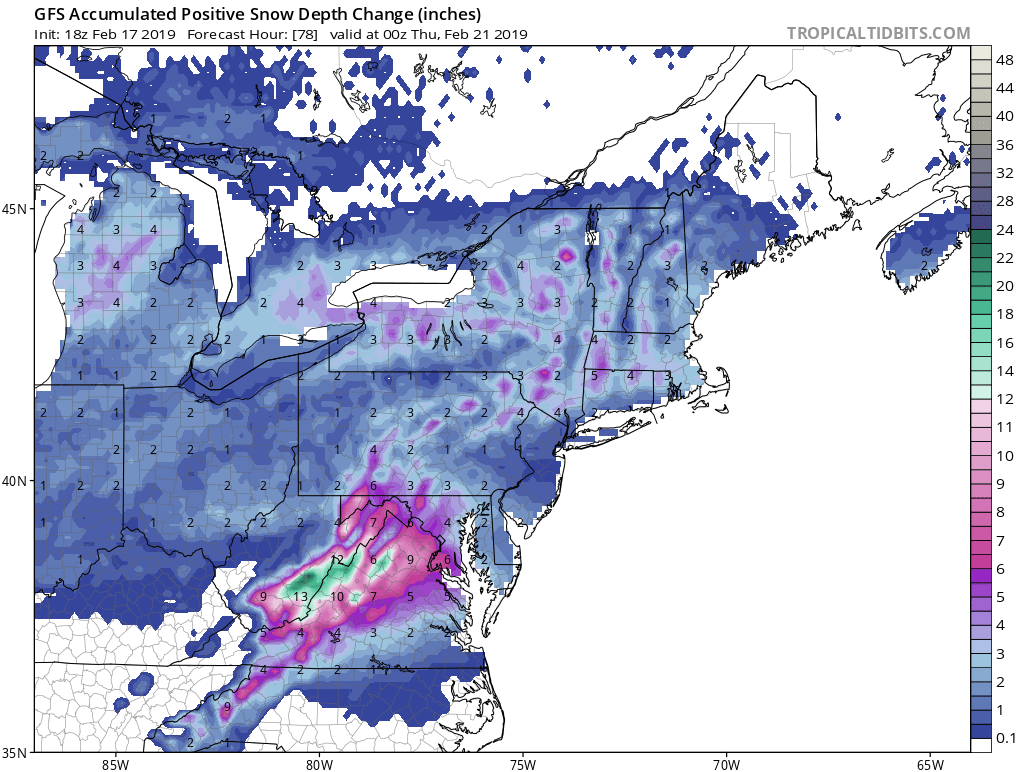
February 19-20th Threat - STORM MODE
in Mid Atlantic
Posted
the run to run consistency with the GFS placement of the band is staggering. It is probably picking up on baroclinic instability between the CAD and the SE ridge. This tells me that someone will get deathbanded.. just not sure where at this lead.