

Solak
-
Posts
6,434 -
Joined
-
Last visited
Content Type
Profiles
Blogs
Forums
American Weather
Media Demo
Store
Gallery
Everything posted by Solak
-
That's crazy!
-
We haven't had that much in the period 7/1-8/12!! However, I'm collecting more outflow boundaries this evening Peaked out at 88/75 this afternoon. No rain (yet?)
-
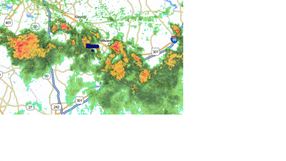
Outflow boundaries converging on Wake Co. Another image shows 5 distinct ones.
-
Can't believe (well, yes, I can) that yet ANOTHER cluster of strong storms washed out 5 miles from the house just now. Heard thunder for an hour, watched the storms coming, then...poof, leaving some residual sprinkles that evaporate on landing.
-
0.03" early this morning. 0.35" over the last 7 days.
-
The weather is broken! No chance of rain for the next 2 days!!! 0.15" yesterday.
-
Nothing here from tonight's storms so far, but even though this is down the county a little ways, it's still too close for comfort. At 7:47 PM EDT, 2 NE Four Oaks [Johnston Co, NC] EMERGENCY MNGR reports TSTM WND DMG. 13 HOMES WITH TREES ON THEM, 3 SIGNIFICANTLY DAMAGED. A HOME ALSO HAD WINDOWS BLOWN OUT.
-
Missed some strong storms yesterday by 5-6 miles. 0.02"
-
LOL --- go out to mow... it's a 20% downpour out there!!! 0.00" yesterday.
-
Finally got in on the rain. 0.87"
-
0.24"; but just 0.03" from the 'storms'. The rest fell around daybreak this morning.
-
Another near hit... Warned cluster broke up on arrival
-
See this... .AN AREA OF SHOWERS AND THUNDERSTORMS WITH TORRENTIAL DOWNPOURS WILL AFFECT WAKE... NORTHWESTERN JOHNSTON Check RADAR... Yellows and Reds 20 minutes away. Rush out to do some mowing. Total accumulation = T *barely Check RADAR - no returns left on screen. Rained itself out.
-
You know things are bad when you see... This would put the Tennesse/ North Carolina border in the RRQ But you read This would put the Tennesse/ North Carolina border in the BBQ
-
NWS RaleighVerified account @NWSRaleigh 1h1 hour ago The @NWSWPC is forecasting a general average of 2 to 3 inches of rain across central NC for today through Friday night. Much greater localized amounts can be expected. #ncwx
-
LOL - Last update 28 Jul 2:55 pm Actual time : 2:44 pm
-
NWS RaleighVerified account @NWSRaleigh 4m4 minutes ago Another wet pattern is shaping up over the next week across central #NCwx. With daily chances for showers/storms, rainfall accumulation amounts will likely average 2 - 4" over the next 7 days, with higher amounts likely closer to the #SCwx state boundary. http://www.weather.gov/rah
-
Rinse and repeat?
-
06z GFS goes a little crazy on amounts... 16 day TOTAL PRECIP: 9.25 " and Convective: 7.87 "
-
And one more... Allan Huffman @RaleighWx 19m19 minutes ago 12z GFS-13km showing most areas in NC/SC getting 3+ inches of rain next 9 days. Many areas with more than that #ncwx #scwx
-
Brittany Borer @wxbrit 5m5 minutes ago Looking at a LOT of rain over the next several days along the east coast. Stay tuned.
-
Gonna spin the weekend away offshore... Brad PanovichVerified account @wxbrad 51s51 seconds ago Tropical Depression #3 has formed and will becomes a #Chris this weekend and linger for the next 5 days. #ncwx #scwx
-
Closer to home... NHC Atlantic OpsVerified account @NHC_Atlantic 33s34 seconds ago A tropical depression is likely to form and stall or meander near the coast of North Carolina through the weekend. Interests along the Carolina coast should monitor the progress of this system. More info available at https://www.nhc.noaa.gov/gtwo.php?basin=atlc&fdays=5 …
-
-
NWS Raleigh threw a new word into my vocabulary overnight I had to Google it! A tertiary cold front looks to push through on Saturday,


