
Castaway
-
Posts
414 -
Joined
-
Last visited
Content Type
Profiles
Blogs
Forums
American Weather
Media Demo
Store
Gallery
Everything posted by Castaway
-

2023 Short/Medium Range Severe Weather Discussion
Castaway replied to Chicago Storm's topic in Lakes/Ohio Valley
Well, that was a surprise. It really was trying to drop tornadoes around. I was busy today and didn’t really look into it much. Seemed weird. Initial thoughts walking out/quickly gauging it, reminded me of some cold funnel set up day. With rotations around/some funnels etc. Came home and saw the velocity scans. Didn’t expect to see some of the videos out in Elgin and the damages in countryside etc The scan earlier over by countryside seemed one of the better ones. Will be interesting to see some videos from there. -
Rotation getting together just west of Batavia
-
Pre-Christmas (Dec 21-23rd) Winter Storm Part 2
Castaway replied to Chicago Storm's topic in Lakes/Ohio Valley
lol. The ol days where being in red meant imminent death. These days it depends on the phone. Red now will carry you for hours no prob. -
Pre-Christmas (Dec 21-23rd) Winter Storm Part 2
Castaway replied to Chicago Storm's topic in Lakes/Ohio Valley
Wonder if there’s a chance it’s being over done on having the low starting out as fast. Which would have it a tick south. Having it more west on Friday than what’s being shown right now on some models. Thinking at least 2” for the Chicago area. -
Anyone see the “face” in the SE? lol captured just now
-
2022 Short/Medium Range Severe Weather Discussion
Castaway replied to Chicago Storm's topic in Lakes/Ohio Valley
Here by Oak Brook small to medium branches down. Nothing crazy, but I didn’t expect much. I was watching it outside for a bit. Thought the 2 cells would split through here and continue sliding SE. Then, it started shifting a little more easterly. Afterward 15mins or so, saw a shelf cloud appear and start rolling in. And had nice gusts. About 100ft row of branches going across the street. One of the more severe “events” IMBY/ neighborhood this year lol. Wouldn’t guess in September. But not surprised either considering the multiple touchdowns we had in the dupage area lately past couple years now. -
2022 Short/Medium Range Severe Weather Discussion
Castaway replied to Chicago Storm's topic in Lakes/Ohio Valley
Some of the lightning/thunder that just passed through sounded epic. I was watching south seeing flashes in the distance with the rolling thunder going across. At one point it sounded like it had a helicopter chopper cutting up the deep thunder thinking from bouncing off the terrain etc. Sometimes these late night storms have some of the best storm sound. Top stuff. -

-
I’m 88 and 83. Feeling the same
-
It’s still there on Radar. It started flaking here nicely in Oak Brook and saw it on radar a bit ago as well.
-
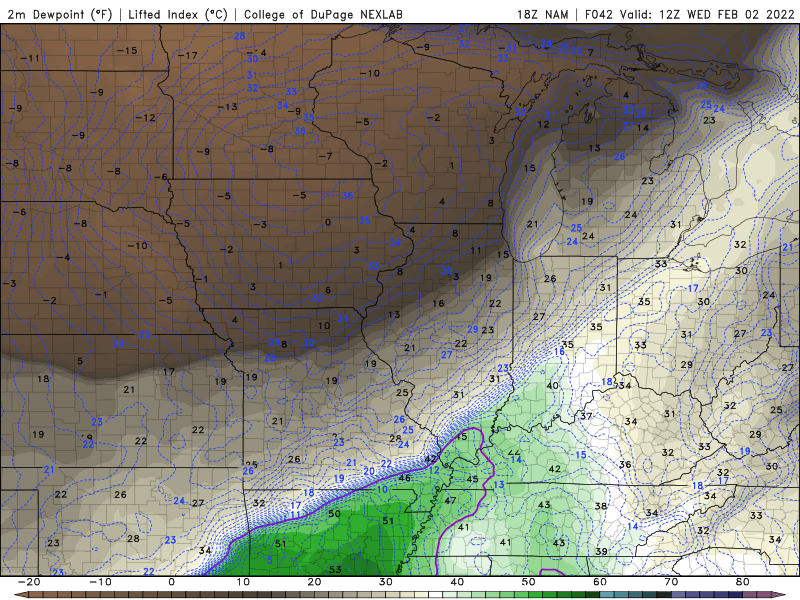
Noticed the dew point drop on the nam earlier with the drier air pushing in. Was thinking it made sense why the sharp cut off is the there in the northern counties. But wasn’t sure if it’s over done etc
-

-
Had a sense earlier it’s May and not December. Being 58 right now with my balcony door cracked for a couple hours watching this. Especially this long tracked tornado with insane debris signatures…
-
Sam seemed to struggle yesterday on the sw quadrant as well for awhile. Just remembering observing it yesterday for hours. Beauty representation earlier. Looks good now, despite the skidding on the sw. Based on pure hunch and eyeballing, it should kick out again and produce some acts of major+ characteristics next hours into tomorrow.
-
Current mesos appear in tandem. appears a more northern/nw track once and if the other meso swings around east
-
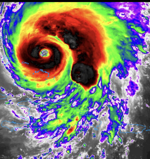
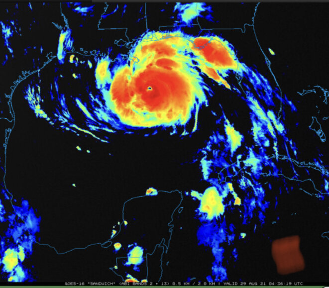
Visually, Ida is essentially text book for an intensifying eyewall at present. You get deformation from isolated intense cells bursting within the eyewall, this leads to mesos. Also radar is still long range with the beam height above ~25 k ft at this time, so it is possible the reflectivity dbz of the core band will become more of a bright ring as Ida gets closer and the beam reflects from lower is the eyewall. We're essentially limited to the higher/most intense elongated cells at this height. Do more dominant meso(s) have an effect more or less of steer. Wobble more or less?
-
Currently based on Radar, with a possible more dominant northern vortex. This looks like currently it’s goin straight northly Dynamically it can pull some of the rest northerly in natural fluidity Next hour will be interesting
-
Buffing up cat 3
-
It’ll be a mixture of highly engineered drones soon I’m thinking. Later human presence will be then evaluated. there will be humans in the thing I’m guessing either way always obviously regardless
-
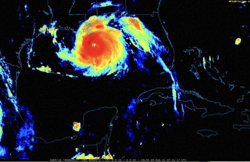
It’s been getting that other look now very recently. Looking more balanced wrapping around Into a more circular disk. It’s intensifying as we speak. if this took a step west yesterday right before Cuba between San Juan y Martinez and Sandino… we’d have a classic buzzsaw by now. edit: this is why I was focused a lot yesterday right before it was hitting western Cuba. If it jogged west just a bit before hitting land. The little farther westerly track would of had this set in buzzsaw prime mode by now. Low elevation. Quicker exit. More time. it’s been intensifying as we speak. Those light bumps yesterday chugged it a bit. Even if by mere hours
-
It seems the current track has the center going between San Juan y Martínez (which has a elevation of 70ft) And Guane which has an elevation around 82ft. If it was tracking more to the East, maybe the terrain there would of had a little more of an effect (200-300ft). Even then, it wouldn’t be that much imo. Edit: Looking at the last 2 frames it looks like it took a good step west. might go over Sandino area. Which has an elevation around 33ft.
-
Some nice tops by elk grove village
-
Have to see if it’ll close off soon. Based on Radar, it certainly has been trending in that direction and continuing. Can’t remember off the bat in recent memory seeing one close off right before/on landfall.
-
The line is losing some steam on its way to Chicago. Sucks. It had some nice frequent lightning and ctgs a bit ago.
-
Showing power outage in Boone county, IA. Cell looked impressive rolling through on radar earlier.


