Hvward
-
Posts
3,523 -
Joined
-
Last visited
Content Type
Profiles
Blogs
Forums
American Weather
Media Demo
Store
Gallery
Everything posted by Hvward
-
I am here at Primland Resort just west of Stuart. Will be interested to see if this verifies!
-
Looks like you guys are in for some fun Saturday and into Sunday! I won’t be sitting this one out but I have a weekend planned at Primland Resort in SW VA. Looks like we could get several inches there as well. Here’s to hoping everyone cashed in!
-
2.5” at my house in Alexander, still snowing pretty hard. That makes 10” total for me this season. .
-
I have a light to moderate snow falling now here in Alexander.
-
Winds will increase rates later this afternoon/evening. Patiences..
-
Snowing pretty good here in Canton currently.
-
Wow HRRR shows a couple of feet of snow for Mt. Leconte & Clingmans Dome Area. I am thinking Waynesville, Canton, Weaverville all the favored NWF valleys are going to get clocked here. Another 1"-3" is possible through tomorrow even in Asheville. This flow is serious and means business. Not sure I have ever seen the models throw out 3'+ totals in the Smokys, but that's what is happening right now. HRRR & Nam 3km.
-
Looks like another burst of snow will be possible for most from 1-3am. Might as well stay up if you've made it this far.
-
A nice dusting already at my house in Alexander! I love how quick it stuck, no wasted accumulation.
-
Should be a fun evening, tongue of precip looks good on radar and I have ribs on the smoker with a popped top already. Hope everyone gets a surprise!
-
Yeah that cold air could lock it for a couple more hours. Wouldnt be surprised to see you wake up to a couple of crusty inches Sunday morning.
-
Looking at soundings on the HRRR and NAM 3km, there is a considerable difference on early Sunday morning. It does appear that the tongue of precip will move through initially around 3pm-5pm, and that will persist in the northern area of WNC through 10pm or so. Most of that will fall as snow. But I don't think it accumulates. Then the soundings differ. NAM 3km has a bit more pronounced warm nose at the onset of precipitation early Sunday morning. HRRR is not as cold, but doesn't have the pronounced warm nose. I see a couple hours of snow possible early Sunday even for valley locations. Then a mess will ensue it looks like. Hoping the HRRR is right and its a bit warmer because ice is not very fun.
-
Trends have been away from this solution over the past 2 runs with precipitation trending farther south.
-
Nam & Nam 3km are both showing some higher elevation snow showers across SW WNC Friday afternoon/evening. Might have a tongue of overrunning precipitation that the models are struggling to pick up on enter the area sometime on Friday. Something to watch, especially if you live above 3500'.
-
Couldn’t get this to load earlier but this is the entrance to a neighborhood in Asheville where I am about to build 3 homes. Went over there to stake them out this morning and this was the view!
-
Some surprises wintry precip happening across MS, AL, & GA. Sitting here wondering if that sneaks into the SW mountains later tonight. Models have it drying up, but we know how that goes sometimes. Thinking someone might at least see a snow shower from it tonight.
-
Looks to be snowing already per my Maggie Valley Camera. I think several get in on the snow action today.
-
Still looking at a chance for some snow showers around the area Monday night and into Tuesday.
-
The radar looks really nice. That deformation feature is already looking beefy!
-
Might have to adjust that a bit tomorrow. Such a tough forecast. Here’s the 18z Euro. .
-
There will be a struggle to model where the deformation feature sets up. That could be what the NAM is attempting to resolve.
-
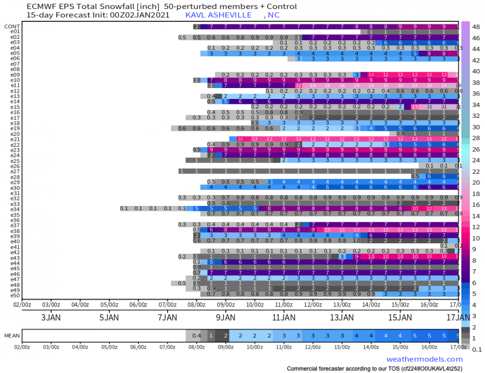
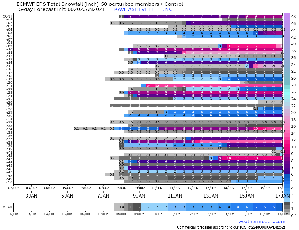
I am looking at a lot of paste bomb soundings right now for Thursday night and early Friday morning. Wonderful dynamics for heavy, wet snowfall. Model totals kept increasing today. EPS and GEFS means up around 6” for KAVL.
-
Yep! 3 chances at snow for many over the next 10 days. Good times friends.
-
Friday into Saturday could be a legit threat. Temps are going to be borderline, but it looks like the ULL could help get it done here in the mountains of WNC. GFS just dropped 4” of snow at KAVL.
-
Interesting setup coming here on Friday and into next Saturday. Still looking for some cohesiveness among models, but all three major models show some form of snowfall for many around WNC during the mentioned time frame. The EPS is actually very bullish for this event. Its all going to depend on that ULL capturing the surface low as it transfers. One of these situations is bound to work out in our favor. Eventually if we get enough ULL's to come through one will catch a surface low and we will be in business. Main takeaway is that a -NAO is poised to develop and that will significantly increase our chances for a low to stall as it transfers. From what I see, we will have several chances for ULLs to move through with surface lows in favorable positions for a SE snow over the next 3 weeks. Should be some fun times of tracking!