

Hvward
-
Posts
3,523 -
Joined
-
Last visited
Content Type
Profiles
Blogs
Forums
American Weather
Media Demo
Store
Gallery
Everything posted by Hvward
-

2022-2023 Fall/Winter Mountains Thread
Hvward replied to BlueRidgeFolklore's topic in Southeastern States
Man we need this one bad people are getting stark crazy over snow lol. -
2022-2023 Fall/Winter Mountains Thread
Hvward replied to BlueRidgeFolklore's topic in Southeastern States
NAM is all over the place. Maybe just some token flakes Thursday night/Friday AM. We will see but NAM doesn't have the stream of moisture as far north compared to previous runs. -
2022-2023 Fall/Winter Mountains Thread
Hvward replied to BlueRidgeFolklore's topic in Southeastern States
We have the NAM, NAM 3km, RDPS, Canadian, & GFS all showing snow showers to a good portion of WNC late Thursday night and into Friday. This looks like it could actually happen. Might sneak up on us! Sounds look pretty good though from most models, Nam and NAM 3km even showing some accumulation. -
2022-2023 Fall/Winter Mountains Thread
Hvward replied to BlueRidgeFolklore's topic in Southeastern States
Impressive snowfall totals showing up on the 12z NAM 3km. I’ve been saying this for a while but someone is going to get hammered. 3km even picking up on that Buncombe Co streamer. Looking forward to the first decent snow of the season for many! -
2022-2023 Fall/Winter Mountains Thread
Hvward replied to BlueRidgeFolklore's topic in Southeastern States
This one is a long ways from over. The Gfs transferring the Low from the Ohio valley to Coastal NC won’t happen. The more southern solutions seems plausible at this point in time. Enjoy the ride on this one we are going to see big time swings, but someone up here is going to get hammered imo Friday and into Saturday. -
2022-2023 Fall/Winter Mountains Thread
Hvward replied to BlueRidgeFolklore's topic in Southeastern States
Razor thin margin for rain/snow on Tuesday around WNC. We've seen this before. These type setups have been known to produce 1"-2" surprise events for portions of WNC. Short range models should provide a much more clear picture over the next 36 hours. -
2022-2023 Fall/Winter Mountains Thread
Hvward replied to BlueRidgeFolklore's topic in Southeastern States
Models don't even have a handle of what will happen on Monday Night/Tuesday. This could still produce some snow showers. As far as the storm to end the week next week, there are a ton of moving pieces. Does the Northern stream dip all the way to the Gulf or does it pop a low in the middle of the US and phase with the PV or will it dip under the Appalachians? Models are cutting it now, but this could easily trend back to a Gulf Low. I am looking forward to seeing the 12z Euro and what it does with the LP. -
2022-2023 Fall/Winter Mountains Thread
Hvward replied to BlueRidgeFolklore's topic in Southeastern States
GEFS also hinting at snowfall for the Monday night and Tuesday timeframe. The models don't have a total grip on this pattern change, I could see a few sneaky events. Flurries might not stop for a while after they begin in the high elevations sometime Saturday. Fun times ahead, doesn't feel like we have seen a pattern like this in quite some time. -
2022-2023 Fall/Winter Mountains Thread
Hvward replied to BlueRidgeFolklore's topic in Southeastern States
Here you go! Looking forward to this pattern change. At the least NWF areas should get hammered next Friday and Saturday. . -
2022-2023 Fall/Winter Mountains Thread
Hvward replied to BlueRidgeFolklore's topic in Southeastern States
Excited to kick the season off! Hope everyone had a good Summer & Fall, model tracking season is back in full action! -
2021-2022 Fall/Winter Mountains Thread
Hvward replied to BlueRidgeFolklore's topic in Southeastern States
Got my garden ready for the freeze! Hopefully my blueberries still produce this year! -
2021-2022 Fall/Winter Mountains Thread
Hvward replied to BlueRidgeFolklore's topic in Southeastern States
Models trending towards a decent even here. Some surprises in store for sure imo. Here is my map.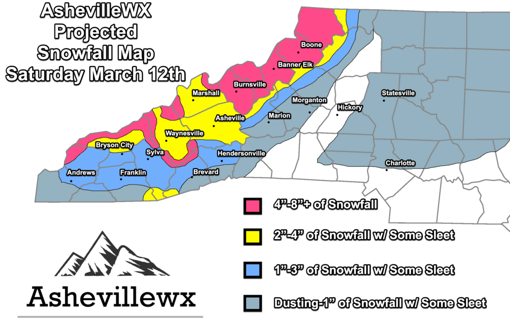
-
2021-2022 Fall/Winter Mountains Thread
Hvward replied to BlueRidgeFolklore's topic in Southeastern States
About to board the plane and head back from Maui! Looks like a decent NWF on Sunday and into Monday. Decent dynamics here with the piece of energy enhancing the stream. -
2021-2022 Fall/Winter Mountains Thread
Hvward replied to BlueRidgeFolklore's topic in Southeastern States
Looks like one of the best NWF we have seen in quite some time setting up on radar. I bet even Brevard and Hendersonville see NWFS. Grab a cold one this is going to be a fun night! -
2021-2022 Fall/Winter Mountains Thread
Hvward replied to BlueRidgeFolklore's topic in Southeastern States
Snowing hard in Leicester, the ground is covered. -
2021-2022 Fall/Winter Mountains Thread
Hvward replied to BlueRidgeFolklore's topic in Southeastern States
Here is my projected accumulation map. . -
2021-2022 Fall/Winter Mountains Thread
Hvward replied to BlueRidgeFolklore's topic in Southeastern States
Yep 4-5 hours of heavy snow for most per 18z hi res nam on Friday evening for many of us. -
2021-2022 Fall/Winter Mountains Thread
Hvward replied to BlueRidgeFolklore's topic in Southeastern States
I am thinking this NWF/Deformation feature could be very interesting. Good dynamics for a couple hours of heavy snow Friday night. -
2021-2022 Fall/Winter Mountains Thread
Hvward replied to BlueRidgeFolklore's topic in Southeastern States
Long way to go, but Tuesday needs to be watched. NAM wants to give SW WNC their best snow of the year. Really hoping that happens for places like Franklin, Bryson City, Andrews, ect. Winter weather tracking continues! -
2021-2022 Fall/Winter Mountains Thread
Hvward replied to BlueRidgeFolklore's topic in Southeastern States
Leicester Highway. . -
2021-2022 Fall/Winter Mountains Thread
Hvward replied to BlueRidgeFolklore's topic in Southeastern States
Roads are covered with a light dusting of snow here In Leicester. Looks like a dangerous commute around Asheville this morning. -
2021-2022 Fall/Winter Mountains Thread
Hvward replied to BlueRidgeFolklore's topic in Southeastern States
Don't look now, but 12z HRRR begins snow in Haywood Co around noon. -
2021-2022 Fall/Winter Mountains Thread
Hvward replied to BlueRidgeFolklore's topic in Southeastern States
The devil is in the details with this one. Pull up a sounding, any sounding around WNC over the next 3 days and tell me that's not borderline snow. Skew-T says freezing drizzle best guess estimated precipitation with a column of air completely below freezing? Does the model not think the precipitation will push up into the dendritic growth area? Those 6000' peaks to Asheville's SW certain could help... Just because the precip maps and accumulation maps aren't showing the colors, doesn't mean that the atmosphere isn't ripe. Hell the 6z GFS has a snow sounding for tomorrow morning for most of you. The main takeaway is that the models are really struggling. They struggled like this in Dec 2017. That northern periphery of moisture was never really correctly modeled and finally it was assumed to be a nowcast event. I remember the GFS and Euro showing small stripes of snow over WNC and E TN a couple days out from the event and thinking they were warning shot. I think we are seeing something similar here, maybe on a less intense scale but today should be the day we see some type of movement in the models. I feel like we sit in a pretty good position. -
2021-2022 Fall/Winter Mountains Thread
Hvward replied to BlueRidgeFolklore's topic in Southeastern States
Indeed and if you remember it speed up, that models shows Friday evening and we got hammered starting at 9am Friday morning. -
2021-2022 Fall/Winter Mountains Thread
Hvward replied to BlueRidgeFolklore's topic in Southeastern States
12z GFS showing a saturated dendritic growth zone around WNC Thursday evening with temps in the upper 20's at the surface. I know its not showing up on the precipitation maps but that is very close to a snow sounding. Lets see if the Euro holds it ground, I bet it does.


