

Hvward
-
Posts
3,523 -
Joined
-
Last visited
Content Type
Profiles
Blogs
Forums
American Weather
Media Demo
Store
Gallery
Everything posted by Hvward
-

2023-2024 Fall/Winter Mountain Thread
Hvward replied to The Alchemist's topic in Southeastern States
The pattern setting up for Mon/Tues of next week has moisture and cold, two things we haven't been able to line up yet this season. I just looked back at the last 10 runs of the GFS and at this range, I would take any of those setups this far out. Magic can happen here in WNC with patterns like this. Euro also has a very nice look now, but looking back at the past several runs, it has been all over the place. Now it is showing something similar to the GFS. At this range, this is a pattern we should all like. Setups similar to this have worked out many times in the past for us. Looking forward to coming home from Puerto Rico and tracking this beast. Full disclosure I was really pulling for the last system to turn into a dud since I was going to be out of town lol. -
2023-2024 Fall/Winter Mountain Thread
Hvward replied to The Alchemist's topic in Southeastern States
Amped up and no strong high pressure to provide cold air has me concerned. Saturday could still happen but the trend is a stronger warm nose today. Euro Ensemble still looks good, but we have seen that miss as well before. -
2023-2024 Fall/Winter Mountain Thread
Hvward replied to The Alchemist's topic in Southeastern States
Just popping in to say this ULL is our first real chance of the season. Someone could get hammered very quickly. -
2022-2023 Fall/Winter Mountains Thread
Hvward replied to BlueRidgeFolklore's topic in Southeastern States
Some snow showers possible this afternoon along the border and then it looks like some convective snow showers will be possible tomorrow afternoon around WNC. Above 3500' could pick up a couple of inches here. Winter isn't dead just yet. Temps look to drop into the teens for some Tuesday morning. Thats going to just about do in any buds around. Doesn't matter if they have frost protection or not. -
2022-2023 Fall/Winter Mountains Thread
Hvward replied to BlueRidgeFolklore's topic in Southeastern States
Are we gonna get dopped again by the models? I feel like Charlie Brown.. -
2022-2023 Fall/Winter Mountains Thread
Hvward replied to BlueRidgeFolklore's topic in Southeastern States
Nam starting to pick up on the deformation band. I still think snowfall accumulation is possible. Look at all of that moisture on the Gulf Coast that is projected to move through the area. -
2022-2023 Fall/Winter Mountains Thread
Hvward replied to BlueRidgeFolklore's topic in Southeastern States
Thank you for the kind words ncjoaquin! -
2022-2023 Fall/Winter Mountains Thread
Hvward replied to BlueRidgeFolklore's topic in Southeastern States
HRRR has heavy snow breaking in Haywood tonight around 7pm. -
2022-2023 Fall/Winter Mountains Thread
Hvward replied to BlueRidgeFolklore's topic in Southeastern States
Thanks to you both for the kind words! -
2022-2023 Fall/Winter Mountains Thread
Hvward replied to BlueRidgeFolklore's topic in Southeastern States
18z GFS with a bit better look than what we have seen all day. Lots of variables at play here with this one and a lot to consider. It's going to be nowcast soon. Soundings for the whole event are razor thin. -
2022-2023 Fall/Winter Mountains Thread
Hvward replied to BlueRidgeFolklore's topic in Southeastern States
Wow GFS really falling off.. crazy forecast. -
2022-2023 Fall/Winter Mountains Thread
Hvward replied to BlueRidgeFolklore's topic in Southeastern States
For some reason I just don't think these models are grasping the full extent of the ULL. I guess we will see over the next 36 hours. Deformation feature is going to be key for accumulation and that is notoriously difficult to model. -
Lol this is pretty typical, they will play major catch up soon.
-
2022-2023 Fall/Winter Mountains Thread
Hvward replied to BlueRidgeFolklore's topic in Southeastern States
I would still roll with this look and take our chances. Buzz word is going to start being Dynamic Cooling. -
2022-2023 Fall/Winter Mountains Thread
Hvward replied to BlueRidgeFolklore's topic in Southeastern States
RDPS keeps getting warmer.. that's somewhat concerning. -
2022-2023 Fall/Winter Mountains Thread
Hvward replied to BlueRidgeFolklore's topic in Southeastern States
Looking at soundings and margins are razor thin in the upper atmosphere. 1 degree difference at the surface and that would have all been snow. We will see, this track is far from nailed down. -
2022-2023 Fall/Winter Mountains Thread
Hvward replied to BlueRidgeFolklore's topic in Southeastern States
6z brings back better snowfall totals to WNC but is still on the low end of guidance. Looking at sounds and temps are extremely borderline. I think we continue to see wobbles with the surface low and that’s going to play key with the warm nose presenting itself. Asheville area looks good for at least a couple of inches. Foothills area still very questionable. Not sure that EKY becomes the winner here though. -
2022-2023 Fall/Winter Mountains Thread
Hvward replied to BlueRidgeFolklore's topic in Southeastern States
It looks a little moisture starved to me and it still shows 4” of accumulation around Asheville by 1am Sunday morning. This thing has big time boom potential here in WNC. -
2022-2023 Fall/Winter Mountains Thread
Hvward replied to BlueRidgeFolklore's topic in Southeastern States
No problem man! Glad to be apart of it. I was just a lurker here in 2010. I give a lot of credit to this board. -
2022-2023 Fall/Winter Mountains Thread
Hvward replied to BlueRidgeFolklore's topic in Southeastern States
Wow this is the best 50 member look I have seen in a while on the 12z EPS. -
2022-2023 Fall/Winter Mountains Thread
Hvward replied to BlueRidgeFolklore's topic in Southeastern States
12z EPS increasing totals again. This is really trending our way.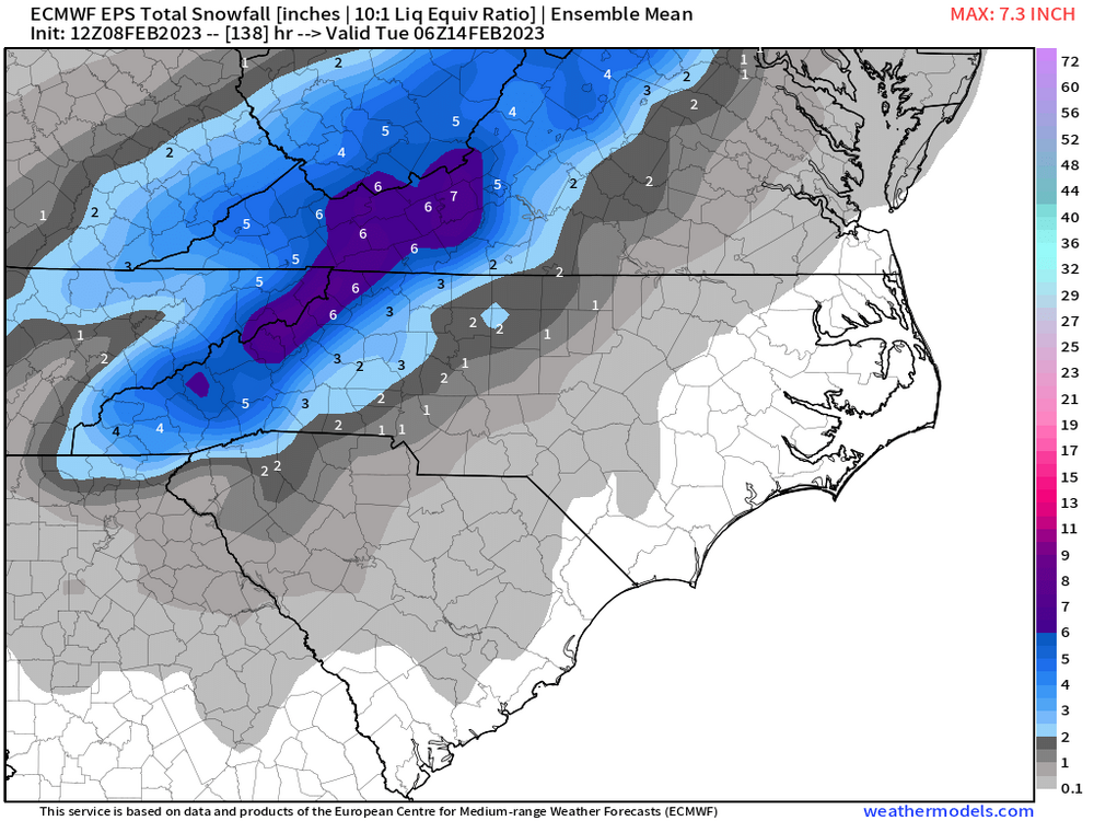
-
2022-2023 Fall/Winter Mountains Thread
Hvward replied to BlueRidgeFolklore's topic in Southeastern States
Don't want to be in the bullseye just yet. I think we have this one right where we want it to get a decent storm here in WNC. Now we focus on when negative tilt occurs and how much moisture the system can pull from the Gulf. -
2022-2023 Fall/Winter Mountains Thread
Hvward replied to BlueRidgeFolklore's topic in Southeastern States
0z GFS is the best run yet for WNC. Really like the trends here. -
2022-2023 Fall/Winter Mountains Thread
Hvward replied to BlueRidgeFolklore's topic in Southeastern States
Euro ensemble certainly trending towards a better snowfall event at 12z. -
2022-2023 Fall/Winter Mountains Thread
Hvward replied to BlueRidgeFolklore's topic in Southeastern States
Woah at the 6z GFS. Hopefully the ULL catching the surface low becomes a trend today.


