Hvward
-
Posts
3,523 -
Joined
-
Last visited
Content Type
Profiles
Blogs
Forums
American Weather
Media Demo
Store
Gallery
Everything posted by Hvward
-
Agree with this. I want 12”-15” max.
-
It really is a lose-lose situation. We either finally get one right or we are always wrong.
-
Nam 3km says this starts for the high elevations Friday around noon. This one could really slip up on us here with all the angst about missing snow last weekend and the negative attitude towards forecasting that many currently have.
-
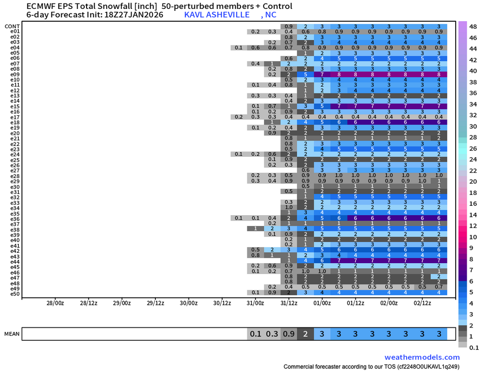
6z Euro with a widespread 6”. I think this continues to trend towards WNC, we could end up being the bullseye.
-
6z Ai Euro coming in much better for WNC, but the down east crew isn't going to like it.
-
Seems that trends continued over night. Lets see what the 6z Euro has to say, but this one looks real.
-
And Franklin, clearing a move towards more snowfall on the 18z runs. Lets see if that continues through the 00z and 06z and it will be real to me.
-
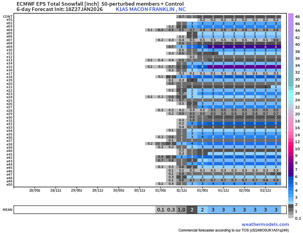
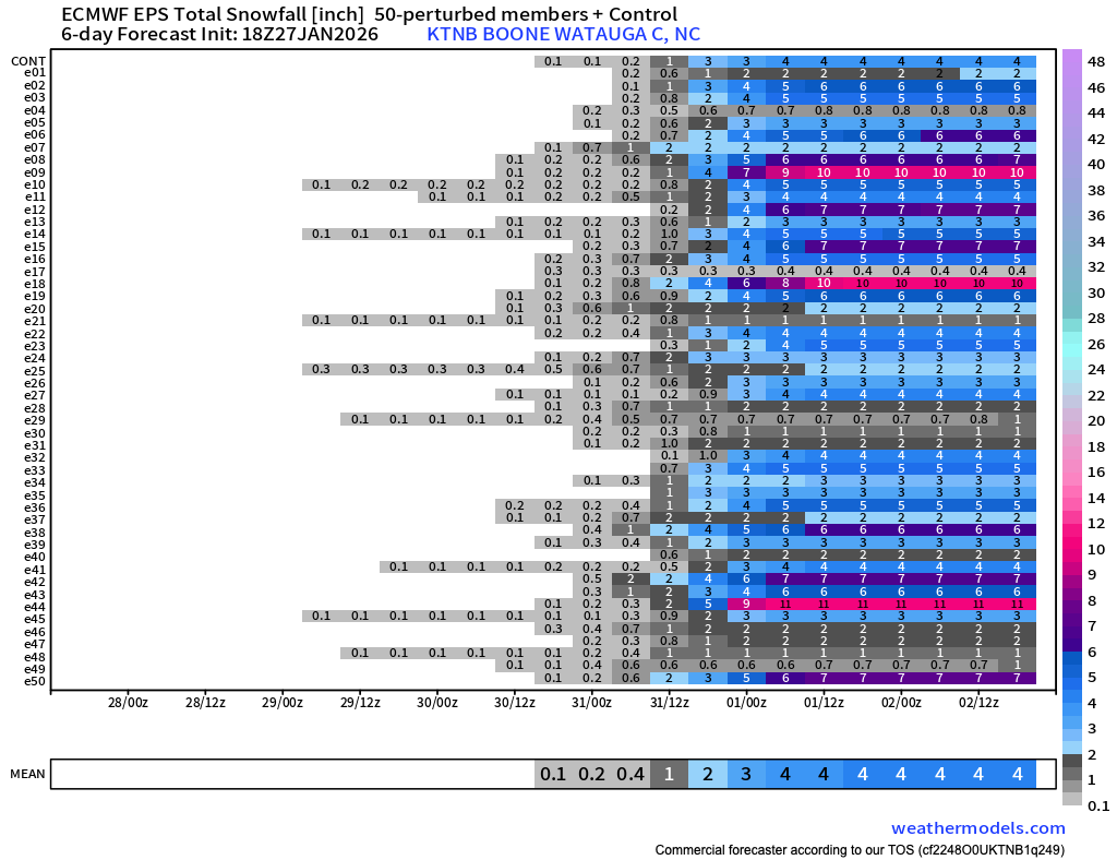
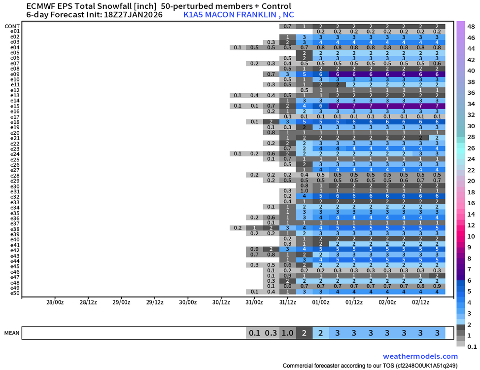
Here are the differences from 12z EPS and 18z EPS for Boone.


-
Substantial changes in snowfall totals from the 12z EPS to the 18z. Here are the two below. Remember they are only taking into account 10:1 ratio. Really feel like something is finally brewing for us.

-
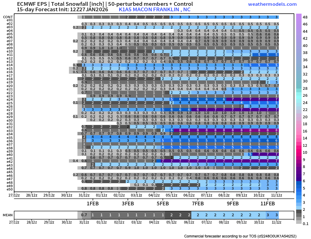
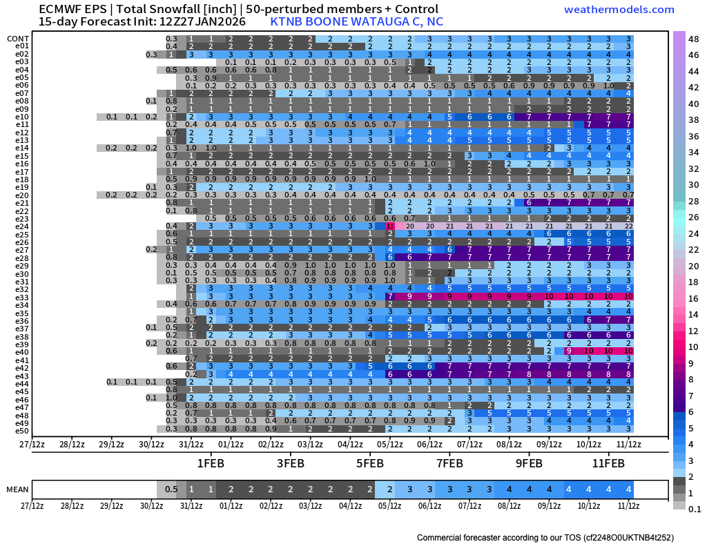
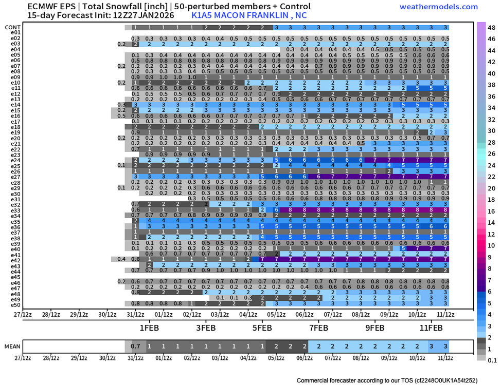
Euro now showing a widespread 6”+ event for most all of us on the 18z. Widespread 4”-8” event now on the table?? That will send WNC back into a frenzy. Winds will be an issue with a pressure gradient like what is being shown. I saw a post today about this not being a big deal that might be regretful.
-
Most models are showing some form of snow showers Friday night and into Saturday for most of us here in WNC. Early phase looks better for a boom, but looks like a 1"-3" or 2"-4" event is on the table for most every model. That's more snow than I have seen in a while, I'll take it!
-
I have a nice dusting now at my house. Amazing how a few degrees of change in direction in the atmosphere can just flood one valley or another with NWF.
-
Full sun here below the Parkway. I don't do well here with Northwest flow. The high peaks absolutely rob this location.
-
Looks like Northwest flow is cranking up pretty good I see it snowing on the ring cam at my Tiny House in Alexander. Looking at the 6z Euro storm is still there and it likes the idea of an earlier phase. That's the solution that works best for us for this weekend. Good Ensemble support for some type of snowfall accumulation on both 0zEPS & 0zGFS as well. Could have some legs.
-

-
So um, anyone sick enough to look at the 18z Euro? 5 days out, that could trend for us.
-
Northwest flow moisture heading this way on the Morristown radar. Looking pretty juicy over Nashville and that will head our way.
-
Appreciate you man. .
-
Up to almost 40 degrees now at my house.
-
Just stepped onto my driveway and slid 5 feet haha. Lots of people calling a storm that already has 15k+ without power a bust. We could see 25k+ without power after these winds bust through.
-
Awesome inversion from my back porch here in Black Mountain. I have around .25” of ice and it looks like the top of the neighborhood may be ice free. Wild storm and still more to come.
-
I am at 22 with light freezing rain falling.
-
Nothing at my house yet really and I consider that lucky. I hope I just get NWFS haha. We sit at 27 so our luck will end soon.
-
little tiny flakes here.
-
HRRR now gives Chattanooga .7” of snow when it has shown nothing. A little front end surprise looks to be in store.