

andyhb
-
Posts
18,509 -
Joined
-
Last visited
Content Type
Profiles
Blogs
Forums
American Weather
Media Demo
Store
Gallery
Posts posted by andyhb
-
-
Conditions on Lake Erie and Ontario late Friday into Saturday are going to be absolutely nuts.
-
 2
2
-
-
Probably should have a separate thread for this thing here.
-
Matures too late on the Euro.
-
1
-
-
GFS way west. Gonna be another cutter before long lol.
-
 2
2
-
-
Could actually see severe blizzard conditions verify over a pretty large area if this thing is as intense as it could be.
This one checks off all the boxes as of now.
“A severe blizzard has winds over 72 km/h (45 mph), near zero visibility, and temperatures of −12 °C (10 °F) or lower.“
-
2
-
-
On 11/20/2022 at 9:25 AM, BuffaloWeather said:
This dude is kind of an idiot tbh, not a great source for vetting.
-
1
-
 1
1
-
-
A fitting finale for this historic event.
Additional low level convergence near/along the cold front is probably enhancing this thing quite a bit. Would have to think that this will kick several places over 80" for the event and many over 70".
-
7
-
-
1 hour ago, Crocodile23 said:
I have some confusion about the 24-hour record snowfall.
NOAA says 50" but this old tweet says otherwise.
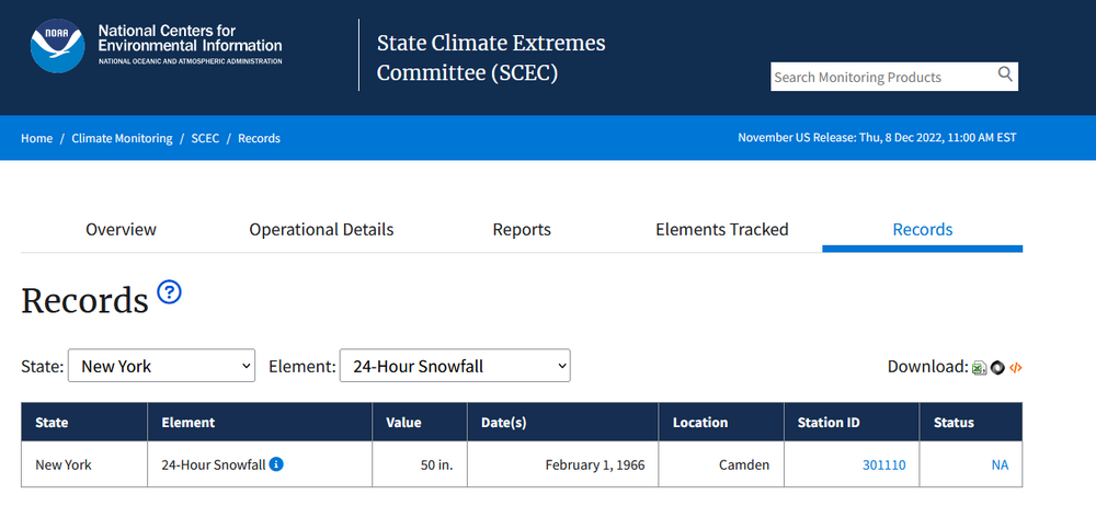
That’s the national versus the state record.
-
1
-
-
This might be the best photo I've seen yet of the "white wall".
-
8
-
-
Band is shifting/expanding north again slowly, southern Buffalo suburbs are just going to have ungodly totals that may eclipse 2014 in spots.
-
3
-
-
I am a bit suspicious of the Orchard Park measurement given it is so much higher than the rest.
-
3 hours ago, BuffaloWeather said:
This stuff isn't light, be careful out there
This is why I think that this event in the end may end up being more impactful than the 2014 event.
You simply can't shovel this kind of stuff in these amounts.
-
2
-
-
22 minutes ago, BuffaloWeather said:
Holy sh*t.
-
1
-
-
8 minutes ago, BuffaloWeather said:
Best chase ever got 10+ bolts and thunder, a 6-7 caught on camera. Uploading after I defrost
Jesus.
-
1
-
-
The latest HRRR is pretty damn ridiculous.
-
5
-
-
3 hours ago, BuffaloWeather said:
If I wasn't excited before I'm officially excited now. Lake effect king called for 40"+ this morning in our discord. What are your thoughts on lightning, band placement/strength, residence time? I might be too far south for this one. Trying to figure out my game plan as my dad lives near the airport and might be better positioned.
I'd probably want to be in central Erie County, maybe a bit north. Lightning is definitely a possibility, if not a likelihood.
-
3
-
1
-
-
Just chiming in to say this one looks like a doozy, certainly haven't seen this type of potential since Nov 2014. Duration might exceed that and the thermos shouldn't be terribly far off thanks to the record lake temperatures. Looks a potential once-in-a-decade type event if not larger.
-
5
-
-
Now have a pair of EF4 tornadoes confirmed from this outbreak. Powderly TX and Clarksville TX/Idabel OK.
-
5
-
-
So far the HRRR has the best handle on current convective evolution, with the NAM 3 km and NSSL WRF being far too bullish on early elevated convection. The environment close to the warm front later looks pretty dangerous from CDS towards OKC. Seems like a low-level flow has ramped up in forecasts as well the closer we've gotten to verification.
-
2
-
-
Monday is trouble for S KS and OK. There will be early convection with the lead wave that passes through, but there is a signal across the board for recovery in its wake with upper 60s dewpoints returning towards the KS/OK border as a strong/progressive shortwave emerges from the Rockies. Should we see recovery and initiation, which I think is nearly certain in S KS and slightly less likely further south, it will take place in a very moist low level environment with hodographs favorable for tornadic supercells. There is regional severe event potential depending on how many storms develop.
-
1
-
2
-
-
TTU WRF also has a couple of intense supercells moving across northern OK later tomorrow afternoon. Seems most of the WRF based guidance is pretty bullish on tomorrow's prospects regarding CI on the dryline, although longevity of the storms still is TBD. Seems like the KS stuff may struggle if it moves into the more stable air too quickly, while any OK storms may have a longer runway of favorable conditions should CI occur that far south.
-
4
-
-
That wave ejecting on Friday definitely has some potential for the southern/central Plains. GFS is the most aggressive and is pretty classic looking both at the surface and 500 mb. Other models are a bit more subdued, need to watch the moisture quality.
-
1
-
-
I think we’re going to need a dedicated thread for Wednesday soon enough. If that trough deamplifies any further from current progs, you’re going to see a scenario where the upper forcing is spread across a very large warm sector (from the Lower MS Valley to Upper Midwest) with favorable moisture and shear profiles for supercells and tornadoes. To me, it has the potential of a large scale outbreak, especially if the NAM/UK/Euro blend are on the right track.
-
5
-
1
-
-
Definitely have concerns that the I-35 corridor in central/S TX including the Austin/Round Rock and San Antonio metros will be targeted tomorrow around rush hour, which is already hectic at the best of times. Many of the afternoon CAM runs indicate the potential for supercells initiating off the Edwards Plateau with very large hail and tornadoes given the forecast soundings around that time. This isn't exactly an area known for potent synoptic severe weather events, either.
-
2
-

Pre-Christmas (Dec 21-23rd) Winter Storm Part 2
in Lakes/Ohio Valley
Posted
I'm still a bit suspicious of how far north the 00z NAM is with the primary surface low during its main development though given the location of the strongest upper level diffluence presented in the model (and also in the 18z Euro, which was the more impressive solution).
Such a difference could make or a break a major storm for many areas, particularly in Michigan/NW OH/N IN.