

andyhb
-
Posts
18,542 -
Joined
-
Last visited
Content Type
Profiles
Blogs
Forums
American Weather
Media Demo
Store
Gallery
Posts posted by andyhb
-
-
This is ridiculously intense damage near Earlington KY.
-
 1
1
-
-
Possibly double digit fatalities in Bremen from the Mayfield tornado. That is a tiny town.
-
 2
2
-
-
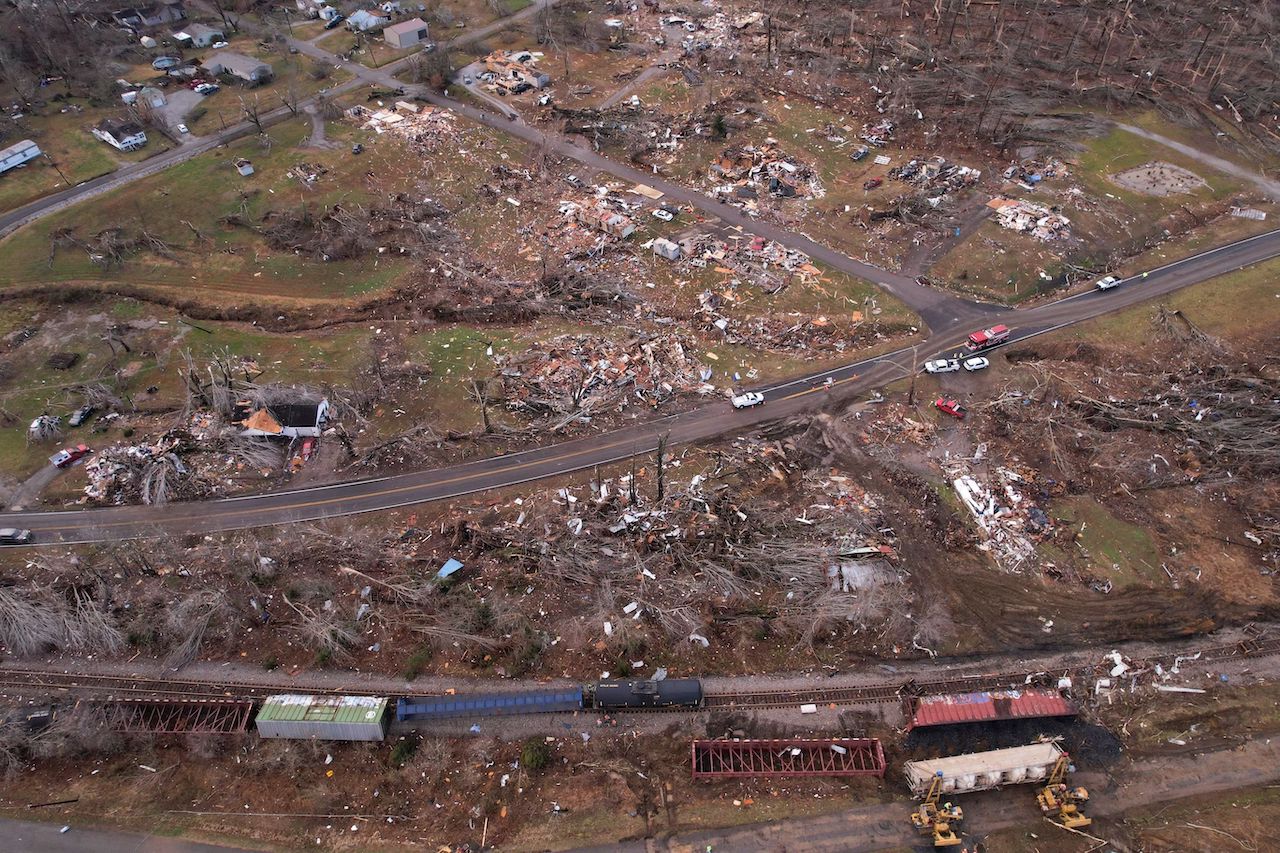
More devastation from the area around Earlington KY.
-
1
-
-
1 minute ago, dan11295 said:
Wonder how far is was continuously on the ground for. Surveys will be able to tell whether is briefly cycled at some point or not. without a doubt will be a an (in)famous long track tornado.
I think it cycled after hitting Samburg, and then the Mayfield tornado started SW of Cayce, likely took out that town, then continued for over 150 miles.
-
1
-
-
Major tornado damage in Samburg TN near the end of the path of the first long-tracked, violent tornado from the main supercell (which was indeed a tri-state tornado).

-
1
-
-
Bowling Green at least EF3, 150 mph per NWS Louisville.
-
11 minutes ago, BuffaloWeather said:
Estimated wind speed for that Mayfield tornado?
In excess of 170 mph (EF4+), that's my only estimate for now.
-
1
-
 1
1
-
-
Total devastation in Morton's Gap KY.
-
1
-
-
7 deaths in Bowling Green KY per scanner.
-
Large tornado just west of Nashville coming into the northern part of the metro, my god.
-
I really, really hope this is a case of lost in translation.
-
1
-
4
-
-
Another likely strong tornado from the Bowling Green storm.
-
Debris to 35k feet on that Mayfield storm. Easily an EF4 or EF5.
-
1
-
-
TBSS from the debris in that Mayfield tornado. Oh my f*cking god.
-

Going to go again here and it's going to be big.
-
Just a massive tornado, has finally occluded from the looks of it, but I doubt that supercell is done.
-
Holy sh*t.
-
Ugly reports starting to come in from NE AR.
-
1
-
-
TORE for the Bootheel tornado.
-
Now just spiked well over 200 kts GTG. Violent, violent tornado.
-
1
-
-
That long-tracker that just crossed into the Bootheel is just an absolute monster. 170 kts GTG currently and has been stronger with an enormous TDS.
-
1
-
-
So that 16z HRRR is probably nudging towards territory that would warrant pink in the convective outlook. Multiple pre-frontal supercells in highly volatile shear/sufficient low-level buoyancy environment.
-
2
-
-
Td of 69˚F at Memphis before 10 AM in December is pretty much absurd.
-
Have some 2/28/2017 vibes from that 12z HRRR run. We are dealing with some pretty incredible moisture for December (or any cold season month, really) and it should get pretty far north given the lack of morning convection.
-
1
-
Dec. 10-11 Severe Weather
in Lakes/Ohio Valley
Posted
https://www.facebook.com/stevecampbell23/videos/620717605842904
This right here is one of the most complete wipeouts I've ever seen after a tornado. Bremen, KY.
High end EF4/EF5 material.