

andyhb
-
Posts
18,511 -
Joined
-
Last visited
Content Type
Profiles
Blogs
Forums
American Weather
Media Demo
Store
Gallery
Posts posted by andyhb
-
-
The sound from 3:25 on is just ferocious...
-
Merry Christmas to all of the folks in Joplin, here's to a continued recovery.
-
Also, Extreme Makeover Home Edition (the show) has been canceled. The Joplin episode on January 13th is the last show that will air, it is also the series 200th episode.
Great way to finalize it.
-
Classic fall storm moving into the Coast. Definitely a wind producer as well as heavy rain/snow at higher elevations. Sub 975 mb sfc low right now.
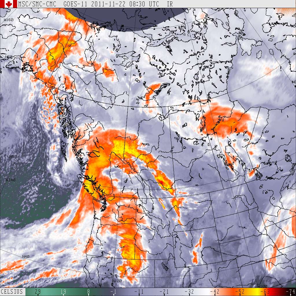
 Metro Vancouver
9:08 PM PST Monday 21 November 2011
Wind warning for
Metro Vancouver continued
Southeasterly winds of 80 to 100 km/h over coastal sections of the central coast, north and West Vancouver Island tonight.
South to southeast winds of 70 to 90 km/h over Metro Vancouver, Fraser Valley, Southern Howe Sound, East Vancouver Island, Sunshine Coast, and Southern Gulf Islands tonight.
A burst of southwest inflow of 80 to 100 km/h affecting inlets of the central coast Tuesday morning.
This is a warning that potentially damaging winds are expected or occurring in these regions. Monitor weather conditions..Listen for updated statements.
Two approaching low pressure disturbances from the Pacific ocean will bring yet another round of unfavourable weather to many regions in coastal British Columbia tonight. Heavy snowfall will continue over Whistler and will begin over Central Coast - inland sections early this evening. About 10 to 15 cm of the white stuff is expected for Central Coast - inland sections while another 20 to 30 cm will likely fall over Whistler tonight.
Rain at times heavy is forecast to develop this evening over the north shore of Vancouver, Howe Sound, the Sunshine Coast and areas from Comox to Parksville on East Vancouver Island. 60 mm of rain is possible over these regions by Tuesday morning.
Strong southeasterly winds will redevelop with the arrival of the next system tonight for much of coastal British Columbia including the Lower Mainland. These winds are expected to diminish quickly Tuesday morning in the wake of the disturbance.
With the track of the low into the central coast of British Columbia, a quick burst of southwesterly inflow of 80 to 100 km/h is possible near Bella Coola Tuesday morning.
-
What an absolute monster...
-
Yeah you just beat me to it

Had to be moving faster than the May '98 derecho to beat you at that

-
I guess you can never fully anticipate an EF5 making a direct hit on a heavily populated area but I think we knew the tornado risk was nonzero even though most of the attention wasn't on that area. I think SPC had a 5% chance there but I'd have to double check that. It was a very bad sign when they were already reporting like 25 deaths right after it happened.
10% hatched around the Joplin area.
-
Just thinking back to that day... the tornado obviously caught all of us by surprise. In the thread everyone was focused on the Midwest and it wasn't until the 70dbz+ debris ball appeared over Joplin that people started posting. Then almost immediately after came Jeff P's dire spotter network report did anyone begin to realize what was happening. We couldn't get tv coverage, radio stations were out, scanners weren't available. Then sometime after, which wasn't more than probably twenty minutes, TWC's Mike Bettes arrived on the scene and we all saw the destruction first hand.
Well...
From what I remember... TWC went live, then national and international stations jumped on the story within the hour and it was a huge mess of confusion because no one knew what was happening.
One thing I personally remember and feeling anxious about was CNN's coverage. After posting in the thread, reading online articles, and watching TWC online... it took CNN what felt like hours to start to report the facts. The headline was "BREAKING NEWS: TORNADO SLAMS JOPLIN, MISSOURI" and they reiterated over and over that no news was coming out of the city, no one knew what was going on, and affiliates were en route... even though, what I remember, TWC was already reporting facts and information was quickly becoming available on, for example, social network sites.
CNN just kept talking about how it sounded bad, no info, then they got a hold of a chaser in Joplin who was at some highway service station that was skimmed and the chaser for probably an hour continued to report his story of "somewhat moderate damage, they saw trees down" etc.
Anyone remember this? I wonder what CNN's deal was. By the time they turned off live programming for the night, they still knew next to nothing, even though other outlets were factual and up to date.
CNN's nonsense was even worse on the day of the April 27th outbreak and the aftermath, I don't even want to go there because it will piss me off, tbqh.
-
And that it was the widest EF5 in US history. Not sure about that one, I thought OKC May 9th 1999 was wider but Tornado Tony might know.
Almost certainly not the widest.
Although, it was similar to the Wichita Falls tornado in 1979 in that it had a wide swath of consistently catastrophic damage.
-
The Rainsville tornado from April 27th tore concrete porches from the ground, tore a stone pillar from a house/broke it in half and threw an 800 pound, anchored safe 600 feet and ripped the door from its hinges, so I'm not surprised a tornado of generally equal intensity would be capable of such incredible phenomena.
-
It was calculated that 2 million cubic yards of debris is attributable to the storm across its relatively short length on the ground.
That is insane.
-
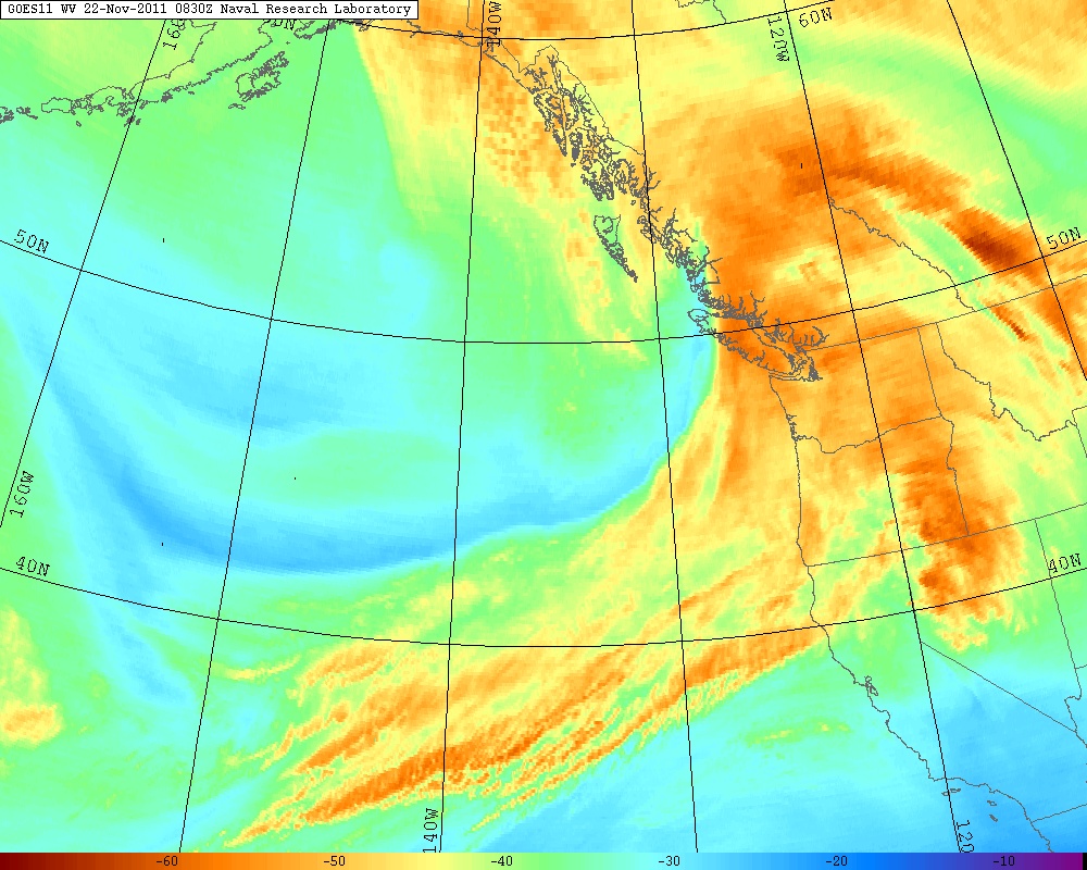
another beauty off the coast of BC
Weather pornography right there.
-
In all honesty, I would've probably had more than a few shudders/stumbles in my wording if something that violent was in front of me...
-
I watched the Jeff and Kathryn Piotrowski chase video. It follows them from Kansas to Joplin where they catch the tornado as it crosses Schiffidecker Ave and continue east on 20th until they have to stop due to debris in the road. They were very close and were almost overtaken by the tornado. The inflow jets were very powerful. There's nothing really disturbing on the video and it has some interviews with people involved in the tornado.
Yeah that part on the video on Youtube where Kathryn screams "BACK UP!" is scarily intense, and then part after you can just hear the desperation in Jeff's voice when he reports the magnitude of the situation.
"I have a very destructive, probably F4...maybe F5...goin' through the city of Joplin right now, on the south side of town and it's doin' massive destruction...It's...It's a mile wide tornado, It's tearin' up the entire city, I'm on the south side of Joplin right now..."
Still get chills from that.
-
Tuscaloosa, AL/Yazoo City, MS/etc.
Not to mention towns have been hit by multiple violent tornadoes in the same outbreaks (Tanner, AL - Super Outbreak, Elkhart, IN - Palm Sunday '65, Fridley, MN - May 6th, '65).
Then I bring up the fact that Codell, KS was struck by a tornado on May 20 three years in a row: 1916, 1917, and 1918.
Forgot about this one....
-
Statistically unlikely of course, but for anyone who thinks it can't happen again in their lifetimes, look no further back than Moore, OK which was struck by violent tornadoes 4 years apart.
Or Jackson, TN.
-
Seems to me based on the service assessment that there may be a push to make "tornado emergency" a separate warning per recommendation 2.
They clearly state they want to maintain the existing POD but want to "provide a non-routine warning mechanism that prompts people to take immediate life saving action in extreme events like strong to violent tornadoes"
Also to modify the warning structure to be more impact based than phenomenon based.
All of the above would be great I think.
I remember several of the original warning texts during the Apr. 27th Outbreak reading something like this:
BULLETIN - EAS ACTIVATION REQUESTEDTORNADO WARNING
NATIONAL WEATHER SERVICE HUNTSVILLE AL
325 PM CDT WED APR 27 2011
THE NATIONAL WEATHER SERVICE IN HUNTSVILLE HAS ISSUED A
* TORNADO EMERGENCY FOR...
SOUTHEASTERN MADISON COUNTY IN NORTH CENTRAL ALABAMA...
SOUTHWESTERN JACKSON COUNTY IN NORTHEAST ALABAMA...
NORTHERN MARSHALL COUNTY IN NORTHEAST ALABAMA...
* UNTIL 415 PM CDT
* AT 319 PM CDT...NATIONAL WEATHER SERVICE DOPPLER RADAR WAS TRACKING
A LARGE AND EXTREMELY DANGEROUS TORNADO ABOUT NEAR ARAB...MOVING
NORTHEAST AT 45 MPH.
* LOCATIONS NEAR THE PATH OF THIS TORNADO INCLUDE...
HEBRON.
COLUMBUS CITY.
GRANT.
WOODVILLE.
LIM ROCK.
LARKINSVILLE.
I kind of thought that might be a good idea in the future, except to create the separate TORE category as mentioned above, perhaps with red text or something like in a PDS watch to highlight the threat of the situation.
-
Amazing story of a 16 year old that is just now getting to come home after being in the hospital. He also got 'the fungus' and only had a 5-10% chance to live. He had a chest wound so bad that doctors could see his exposed lungs, liver and his heart beating through it.
That's incredible.
Devastating tornado strikes Joplin, Missouri
in Weather Forecasting and Discussion
Posted
Compare that to areas like the Oklahoma City, Birmingham/Tuscaloosa and Little Rock metros and it doesn't seem like a lot, although what matters is that Joplin got the big one just like Birmingham and OKC have gotten...