

andyhb
-
Posts
18,479 -
Joined
-
Last visited
Content Type
Profiles
Blogs
Forums
American Weather
Media Demo
Store
Gallery
Posts posted by andyhb
-
-
What a contrast in the weather...
-
Here it is, as it was happening...
http://www.americanw...t/page__st__455
And the thread on alabamawx:
-
Can't believe it's been a year, although once it is around 5:30 PM central, it'll really start to hit...
At the time of the tornado, I was watching the supercell on radar over Joplin and I posted on the alabamawx blog, "Very strong hook echo with debris ball over the Joplin, Missouri area right now, hopefully everyone is alright."
Little did I know how bad it really was...although the signature on radar made my heart sink.
-
Good lord, there were some brutal images going through my head reading that, horrifying...
-
Terrific video.
-
Of note, the three fatalities added to the 4/27 event now make 2011 the second deadliest tornadic year on record in the United States.
-
The second video I posted is a great look at the incredible structure of the parent supercell of the Rainsville tornado (and also 3 other violent tornadoes).
-
And, to what Superstorm posted, what about if that hole around Atlanta wasn't a hole... -
Excellent posts there.
-
From the Rainsville/Sylvania tornado?
-
Well, it's now officially the morning of 4/27, hard to believe that just last year we were watching the overnight convection, along with the SPC's 06z Day 1 High Risk, that in about 12 hours, one of the worst tornado outbreaks in US history was about to unleash its full fury.
-
It does make sense, I can't see anything less than an EF5 causing that kind of scouring.
-
It wouldn't be the asphalt scouring, the EF3 in Americus, GA on March 1st, 2007 scoured the pavement. I remember seeing something in the survey for the Philadelphia tornado that said that a mobile home was thrown 300+ yards without any sign of a ground impact in between, after which it was obliterated, with the fatalities occurring here as well.
I've gone through this thread multiple times since I joined the site and it is always a worthwhile read.
-
The Philidelphia tornado was a very fast mover, and was rated EF5 for hitting an open field. Incredible.
The Philadelphia tornado was rated EF5 for more than just the ground scouring.
Also, the damage to the Wrangler Plant in Hackleburg was incredible.
-
For the record...over on page 50 I said EC's F5 rating for Elie, MB was suspicious. Just recently saw the video of the anchored house being torn off its foundation and thrown hundreds of feet as it explodes. Also saw photos of empty basements left where houses once were. There is surprisinly not a lot of damage photos and videos from that tornado. Sorry EC!
That video also shows a Pampa-like event where a van is picked up and hurled hundreds of yards from its original location, shortly after the F5 damage to the home. This tornado was one of the kings of the "drill-bit".
-
I can easily say that the EF5s in this outbreak were certainly among the strongest ever from a damage perspective...
-
Found this on my computer.
Two of those overshooting tops are easily identifiable. The one North Central/Central AL is Tuscaloosa/Birmingham and I believe the one in NE AL is Cordova/Rainsville.
-
And also how the event progressed from a more linear look on Wednesday to "holy crap this is gonna be a discrete supercell bonanza"...
-
This thread is brilliant.
-
So some good signs were on the HRRR but not the whole package I assume. The other thing I have noticed is that sig. tornadoes have affected some portion of the Joplin metro area not only in 2011 but also in 2003 and in 1971. Three times in forty years sure seems like an awful lot. I would imagine there have been numerous other funnel clouds and a few F0s in the mix as well over the years.
Compare that to areas like the Oklahoma City, Birmingham/Tuscaloosa and Little Rock metros and it doesn't seem like a lot, although what matters is that Joplin got the big one just like Birmingham and OKC have gotten...
-
The sound from 3:25 on is just ferocious...
-
Merry Christmas to all of the folks in Joplin, here's to a continued recovery.
-
Also, Extreme Makeover Home Edition (the show) has been canceled. The Joplin episode on January 13th is the last show that will air, it is also the series 200th episode.
Great way to finalize it.
-
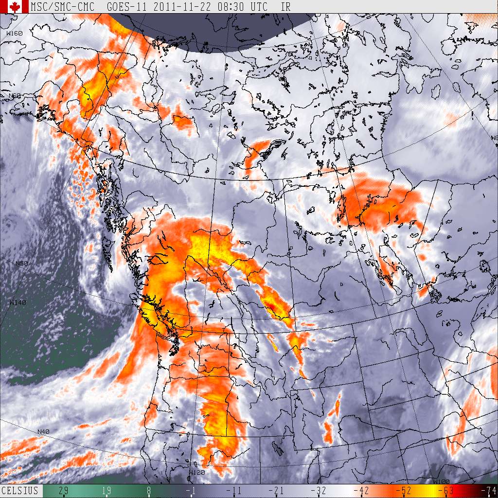
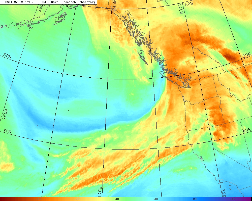
Classic fall storm moving into the Coast. Definitely a wind producer as well as heavy rain/snow at higher elevations. Sub 975 mb sfc low right now.
 Metro Vancouver
9:08 PM PST Monday 21 November 2011
Wind warning for
Metro Vancouver continued
Southeasterly winds of 80 to 100 km/h over coastal sections of the central coast, north and West Vancouver Island tonight.
South to southeast winds of 70 to 90 km/h over Metro Vancouver, Fraser Valley, Southern Howe Sound, East Vancouver Island, Sunshine Coast, and Southern Gulf Islands tonight.
A burst of southwest inflow of 80 to 100 km/h affecting inlets of the central coast Tuesday morning.
This is a warning that potentially damaging winds are expected or occurring in these regions. Monitor weather conditions..Listen for updated statements.
Two approaching low pressure disturbances from the Pacific ocean will bring yet another round of unfavourable weather to many regions in coastal British Columbia tonight. Heavy snowfall will continue over Whistler and will begin over Central Coast - inland sections early this evening. About 10 to 15 cm of the white stuff is expected for Central Coast - inland sections while another 20 to 30 cm will likely fall over Whistler tonight.
Rain at times heavy is forecast to develop this evening over the north shore of Vancouver, Howe Sound, the Sunshine Coast and areas from Comox to Parksville on East Vancouver Island. 60 mm of rain is possible over these regions by Tuesday morning.
Strong southeasterly winds will redevelop with the arrival of the next system tonight for much of coastal British Columbia including the Lower Mainland. These winds are expected to diminish quickly Tuesday morning in the wake of the disturbance.
With the track of the low into the central coast of British Columbia, a quick burst of southwesterly inflow of 80 to 100 km/h is possible near Bella Coola Tuesday morning.
Devastating tornado strikes Joplin, Missouri
in Weather Forecasting and Discussion
Posted
Got a feeling that may be taken the wrong way...
That said, everyone knows about SGF's over-warning problem, its been highlighted several times over the past number of years. Then again, they have had several major events there since 2000; 5/4/03, 3/12/06, 1/7/08, 5/10/08, Joplin, etc...