

andyhb
-
Posts
18,473 -
Joined
-
Last visited
Content Type
Profiles
Blogs
Forums
American Weather
Media Demo
Store
Gallery
Posts posted by andyhb
-
-
It was an EF5. That is all.
-
 4
4
-
-
Columbia MO supercell is looking volatile.
-
Got a couple of cells going up SE of Kansas City. Lead shortwave appears to be impinging on the warm sector.
-
2
-
-
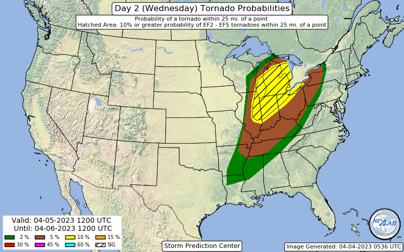
Huge 10% hatched in the latest D2 for Wednesday, including some seriously large population centers. Chicago and east could get very interesting from early on Wednesday.
-
1
-
-
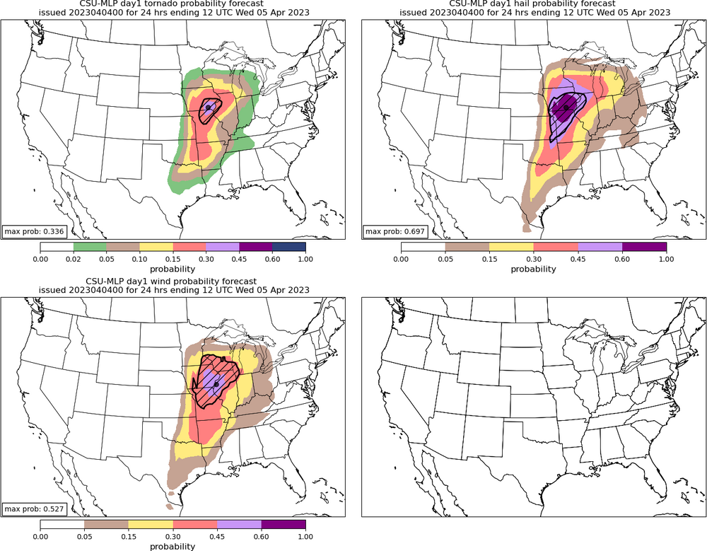
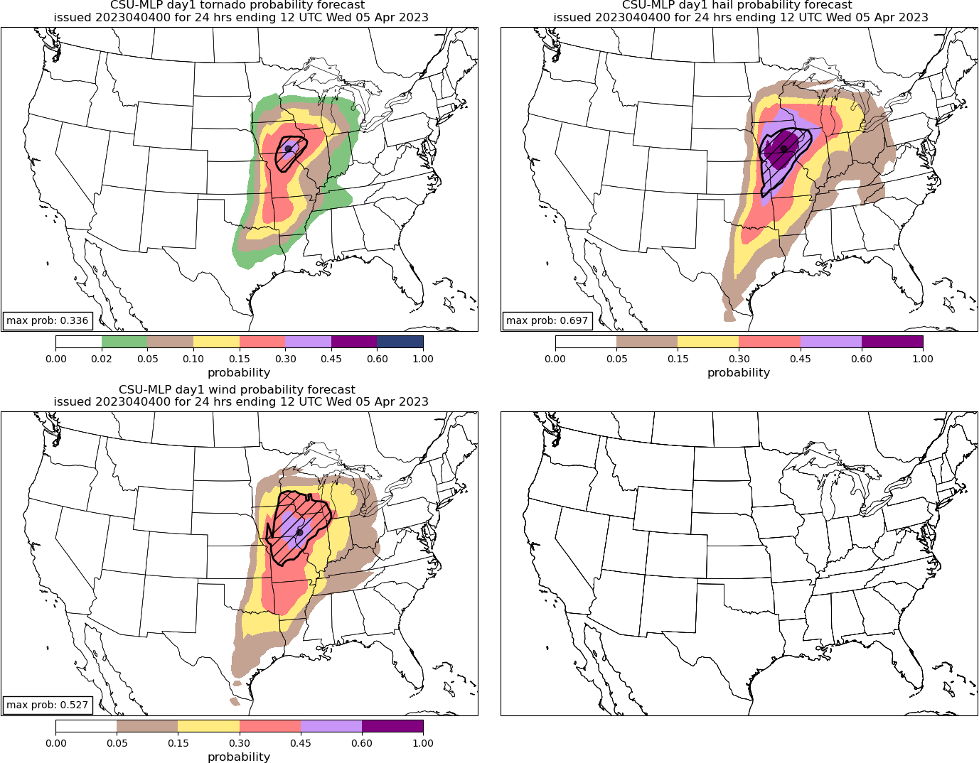
New CSU has a 30% hatched tornado area (high risk equivalent) for the IA/IL/MO triple point region tomorrow. Large 60% hatched hail and 45% hatched wind to accompany it centered on the same area.
-
5
-
-
NSSL WRF also with a monstrous cell tracking from NE MO into W IL in the afternoon. Environment around it is stupidly high end.
Edit: ARW too.
-
1
-
 1
1
-
-
Re: mixing tomorrow and resultant high LFCs and LCLs on the HRRR.
-
1
-
-
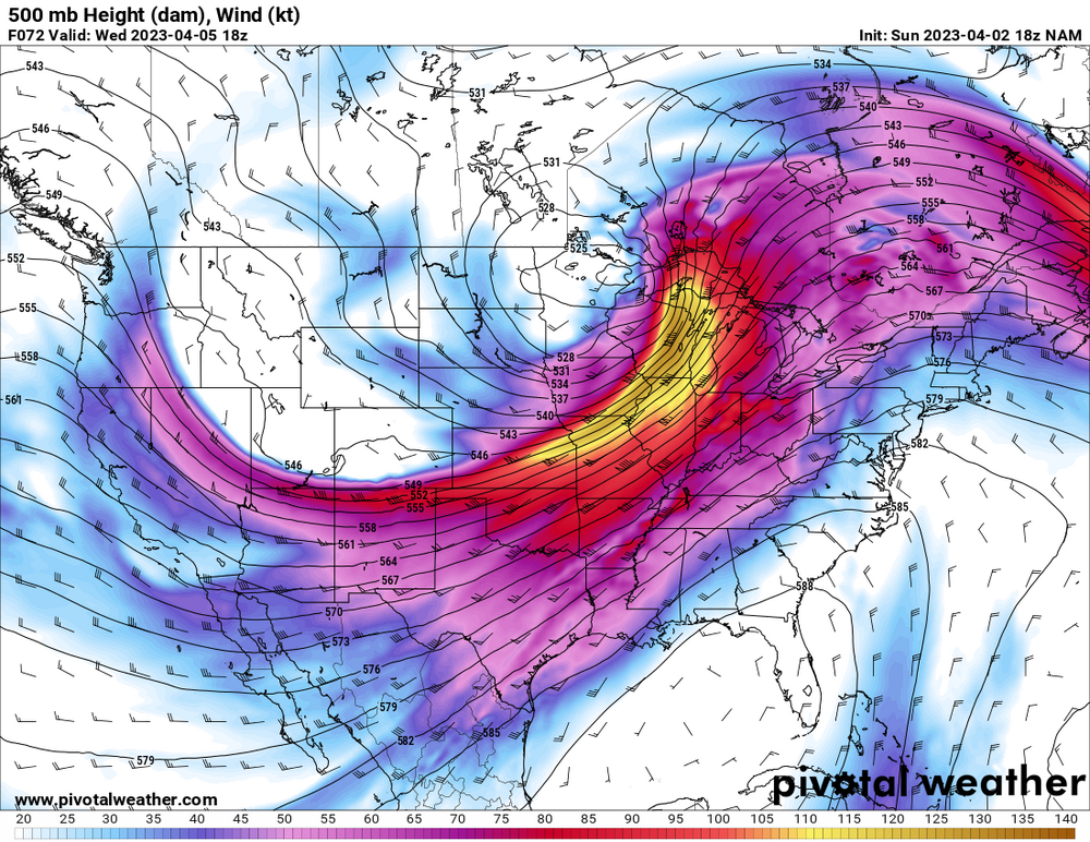
Remains a strong convective signal on the Euro roughly encompassing the current D2 MDT zone, in a highly favorable parameter space.
-
1
-
1
-
-
HRRR has problems with LCL heights early in MO, highlighting the concern with mixing (although it tends to be too aggressive with that).
-
1
-
-
4 minutes ago, MidwestChaser said:
Izzi didn’t seem too impressed per the last AFD.
.Think this one is off timed for the Chicago area. Biggest threat is west on Tuesday, east on Wednesday.
-
4
-
-
That is classic for a significant Great Lakes severe event. Timing/destabilization pending of course.
-
3
-
-
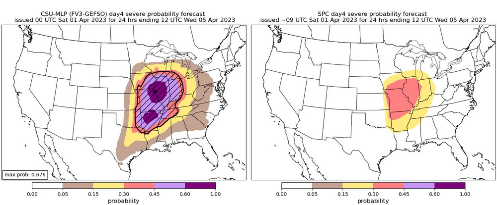
5 hours ago, Powerball said:
Based on the Day 4 SPC outlook for MI/OH/IN, this thread should be expanded to 4/5.
Wednesday has potential to be significant in the Lakes if there’s enough destabilization, 500 mb setup is consistent with some of the bigger early season events in the area.
-
3
-
-
2 additional fatalities in Owen Co. IN.
-
 1
1
-
-
One limiting factor with this may be mixing if we get near the progged high temperatures from some of the models. LCL heights would be an issue.
-
2
-
-
Reports out of Sussex Co. DE are not good.
-
3
-
-
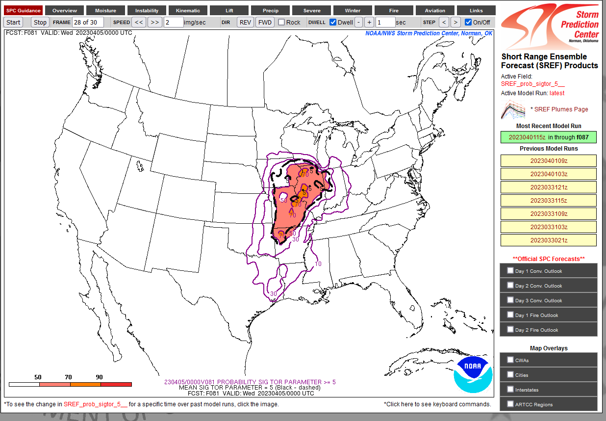
Amazingly high probabilities of STP ≥ 5 over a large area for Tuesday 81 hours out from the 15z SREF. Never seen anything like that at this range.

-
1
-
-
Strong tornado passing very close to the DOX radar right now.
-
1
-
-
41 minutes ago, SmokeEater said:
Over the next 1-2 hours, additional storms are expected to form from the Delmarva across far eastern PA and into NJ, as lift increases. Some storms may become supercells, and the tornado risk will also increase through early evening coincident with strengthening low-level shear and cooling aloft. Any increase in dewpoints will also increase the probability of a tornado.
Sent from my SM-S901U using Tapatalk
HRRR is trying for Mullica Hill part II. Parameter space around that modeled cell is impressive if it does go.
-
2
-
 1
1
-
-
That's at 03z and also I have strong doubt that it is going to be 66 degrees at that time given the magnitude of WAA with this trough. NAM tends to be cold biased.
-
3
-
-
Sullivan IN tornado prelim EF3, 155 mph per IND.
-
The CSU MLP for Tuesday is absolutely maxed out. Two 60+% areas across AR and closer to the low in MO/IA/IL. First time I’ve seen that.
-
1
-
1
-
-
At least 7 dead in McNairy Co. TN from the long tracked tornado last night (the one Fred Gossage was covering).
At least 3 dead in Robinson IL and 3 dead in Sullivan IN. 4 dead in Wynne AR.
-
2
-
1
-
-
44 minutes ago, CheeselandSkies said:
Uploaded an unlisted quick cut to my YouTube channel. Now off to bed.
This video is incredible. Deserves more exposure.
-
6
-
-
Another strong tornado in progress near the AL/TN state line north of Hazel Green.


Mayflower-Vilonia tornado of 2014
in Central/Western States
Posted
This is partially a meme at this point, but the survey was very questionable to say the least. There were a large number of damage indicators ignored. Additionally, there were a couple of houses that are listed in DAT that qualified as EF5 candidates – but were not given such ratings due to some pretty impressive nitpicking – to the point of John Robinson (WCM of NWS Little Rock at the time) saying that some on the committee developing the EF-scale essentially didn't want houses being rated EF5.