

andyhb
-
Posts
18,473 -
Joined
-
Last visited
Content Type
Profiles
Blogs
Forums
American Weather
Media Demo
Store
Gallery
Posts posted by andyhb
-
-
Multiple vortex confirmed with that.
-
No EML = no bueno in the Northeast. Banacos and Ekster 2010, all.
-
 5
5
-
 1
1
-
-
Classic Michigan underperformance... again.
-
 2
2
-
-
Feel like the low magnitude of deep layer shear and iffy mid-level lapse rates/lack of an EML are going to curb this a fair amount. Would assume messy storm mode.
-
1
-
 1
1
-
-
8 minutes ago, SchaumburgStormer said:
Easy sig tor in this video.
-
16 minutes ago, Tezeta said:
are these all birdfarts or are we gonna see a legit EF2+
The larger of the twins out west looked strong from the video.
-
2
-
-
22 minutes ago, Chicago Storm said:
CAM's are overdone on the environment, and likely their solutions.
You sure about that? RAP seems behind on recovery.
-
1
-
-
On 6/24/2023 at 9:11 PM, andyhb said:
I have... thoughts about this, but it's probably not worth getting into a long debate about again. All I'll say is that if this tornado is rated the same as the Cole OK or Lake City IL EF3s earlier this year, that is a pretty damning indicator of the flaws of the EF-scale and how it is applied.
No seriously, what a fucking terrible survey that was after learning more about it. Especially compared to the one from the Didsbury AB tornado from 7/1.
-
2
-
-
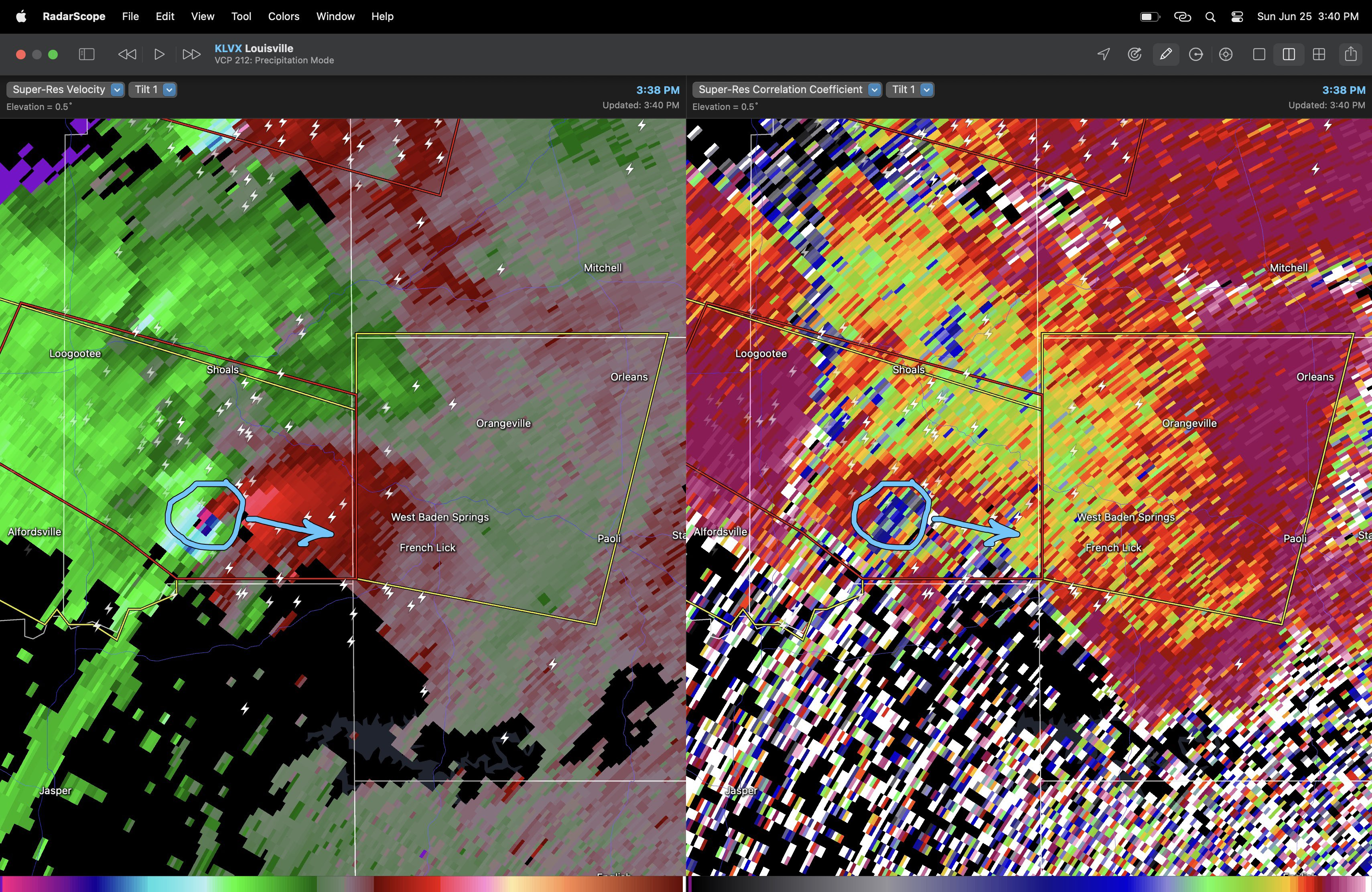
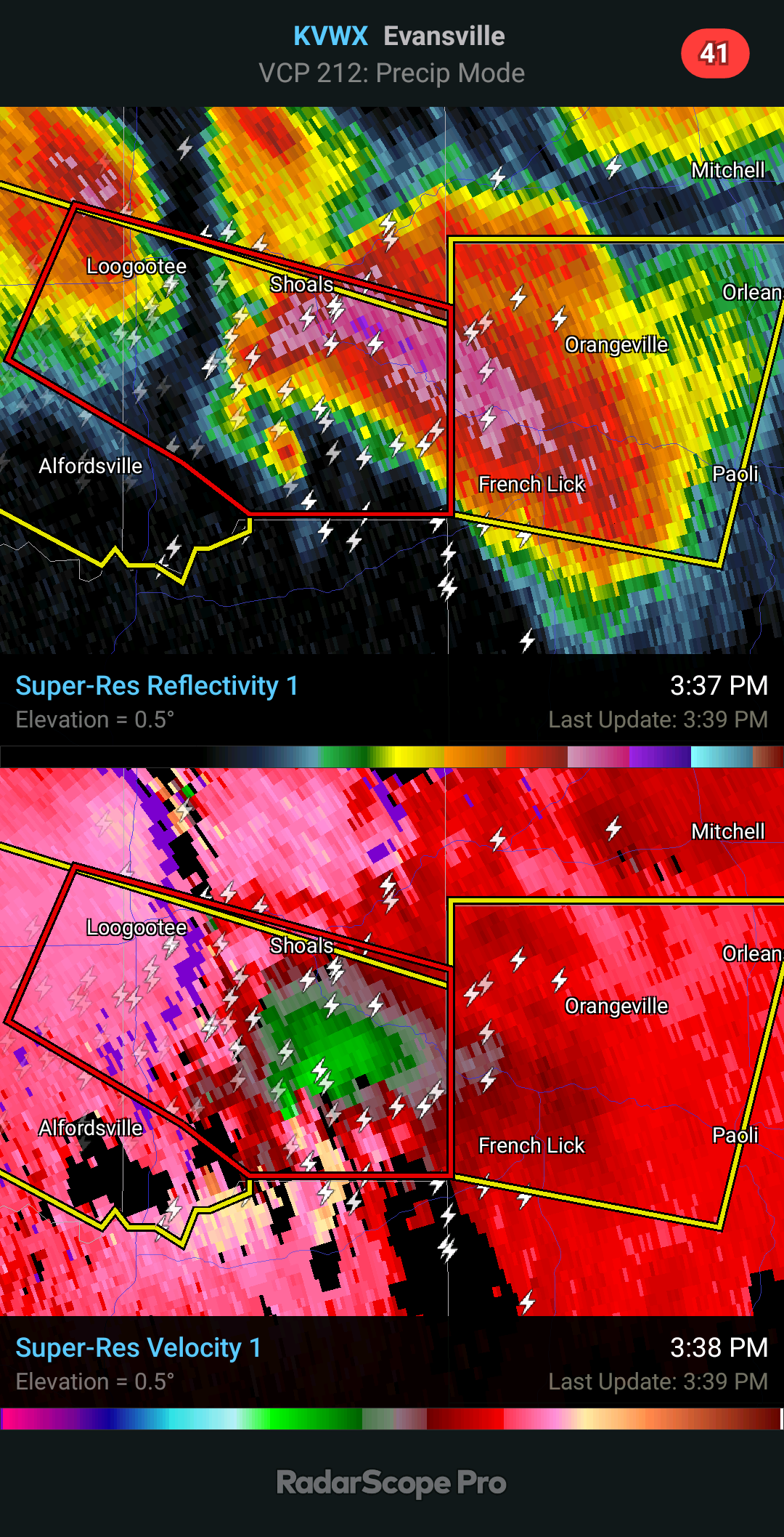
First damage I've seen out of the Shoals IN area.
-
 2
2
-
-
10 minutes ago, StormChaser4Life said:
That's insane. How high was the TDS being lofted?
20k feet at least. Can confirm there was never a TORR on it despite the TDS and intense couplet as it moved from the IND to LMK CWAs.
-
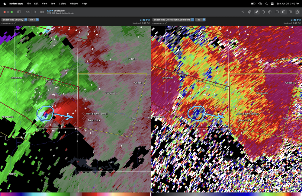
That was a hell of a signature from LVX when it was passing south of Shoals. The damage out there is probably significant.
-
30 minutes ago, StormChaser4Life said:
It appears that this storm may have produced a significant tornado that was never confirmed in the warning. A friend on FB just posted that their Aunt and Uncle's house was hit in Shoals. Unfortunately the uncle passed and aunt was life flighted foe medical attention.
Is there any more information from this one? That tornado appeared to be strong-violent based on the intensity of the mesocyclone and the height of the TDS.
-
-
Convective overturning earlier looks to have stabilized the low levels towards Louisville. Might be done for now.
-
Holy hell…
-
2
-
-
Major tornado in progress east of Alfordsville IN.
-
About to be a tornado outbreak in S IN and N KY.
-
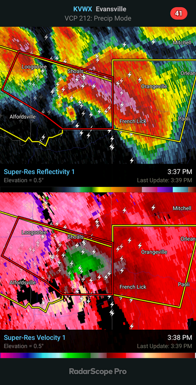
TDS Crane IN.
Also definitely a tornado in the southern suburbs of Indy.
-
Cell SE of Terre Haute could be a real problem in short order here. Meso is very strong from all area radars.
-
6 hours ago, yoda said:
Hmmm
I have... thoughts about this, but it's probably not worth getting into a long debate about again. All I'll say is that if this tornado is rated the same as the Cole OK or Lake City IL EF3s earlier this year, that is a pretty damning indicator of the flaws of the EF-scale and how it is applied.
-
6
-
-
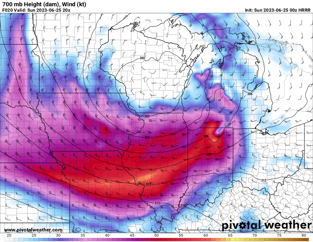
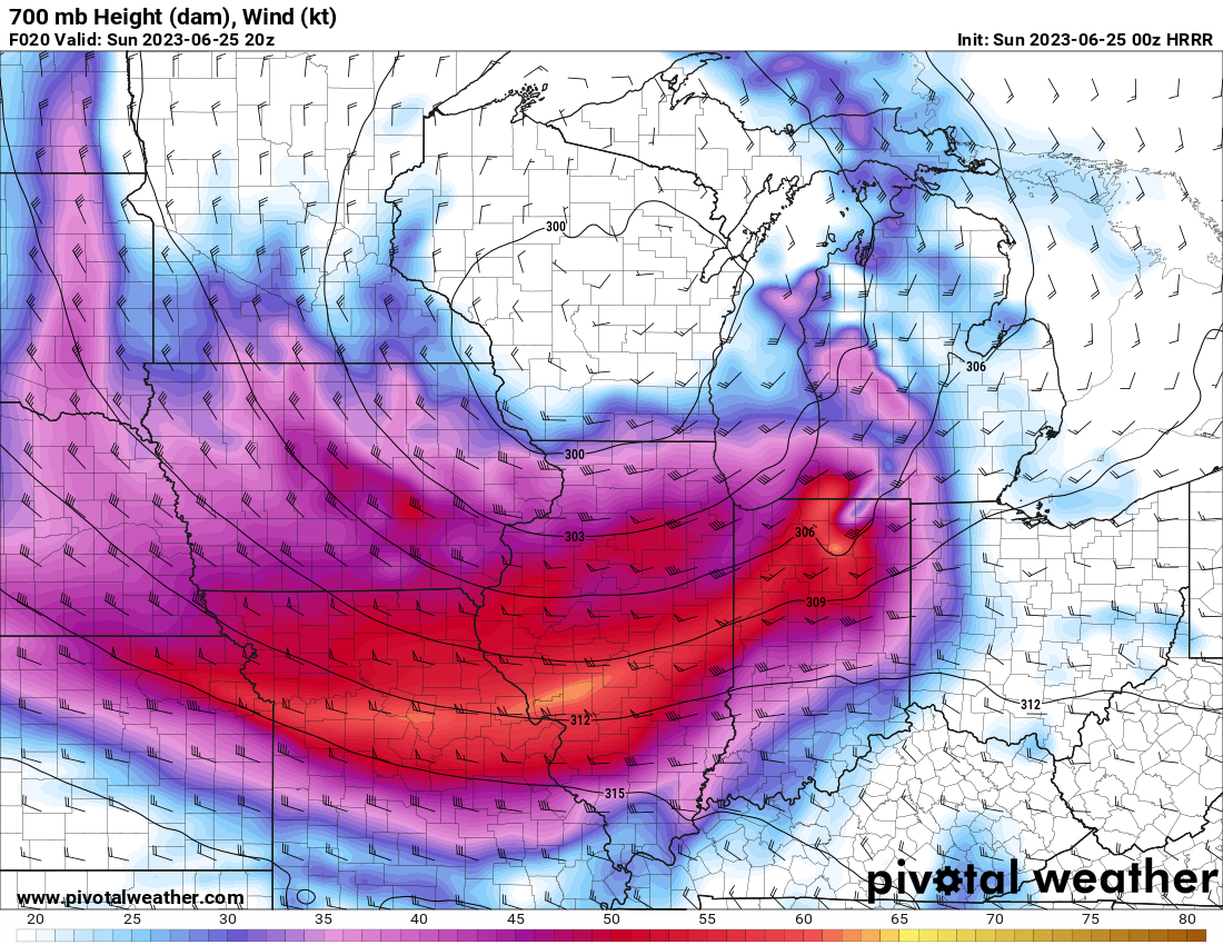
Tomorrow looks pretty impressive to me over Indiana and vicinity. Seems to have the ceiling of a significant regional event given the magnitude of the incoming trough, seasonably strong mid level flow, and potentially favorable storm mode/shear profiles.
-
1
-
-
Major tornado damage S of Grenada CO from the earlier long-lived tornado that @Quincy was chasing.
-
1
-
-
Significant tornado appears to have impacted the North Antelope Coal Mine near Wright WY earlier with the long-lived supercell that moved through central and NE WY. Appears there are people missing and heavy damage including a train derailment.
-
Large tornado in progress south of Midwest WY (north of Casper).
Likely significant.
-
1
-
2023 Mid-Atlantic Severe Wx Thread (General Discussion)
in Mid Atlantic
Posted
Going to need to see improvements in the wind profiles over the Mid Atlantic coinciding with convection to get a higher tornado/sig wind threat here. Current VADs from the area are pretty paltry on low level shear (and the RAP doesn't offer substantial improvements). They are better back in E TN/E KY though.