

andyhb
-
Posts
18,473 -
Joined
-
Last visited
Content Type
Profiles
Blogs
Forums
American Weather
Media Demo
Store
Gallery
Posts posted by andyhb
-
-
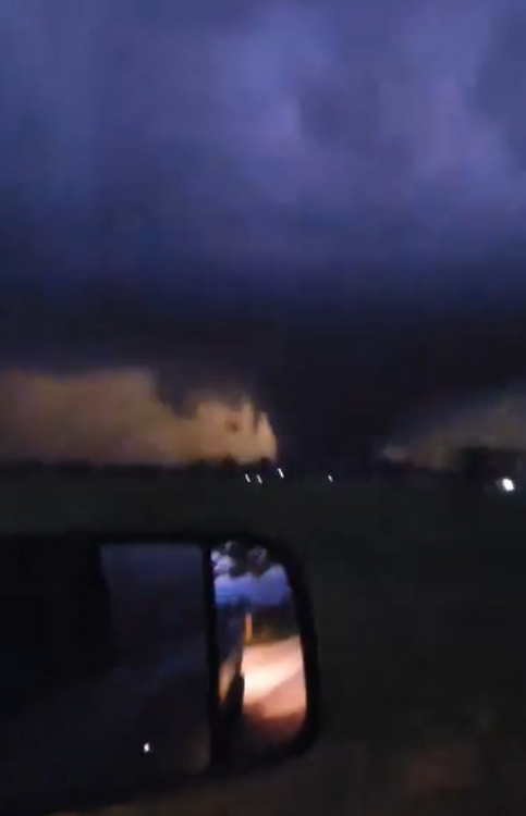
Robinson IL tornado from earlier.
-
 1
1
-
-

Not good in SW IN.
-
 1
1
-
-
Fred Gossage (alumni from here) has a large wedge tornado near Clifton on this stream.
-
Video of the Robinson/Palestine IL tornado from earlier (may be the same as the Sullivan tornado).
-
Sullivan tornado had debris evident at 29k feet from KLOT after it struck town. Was likely violent. Initial reports are not good.
-
1
-
-
Sullivan IN just took a direct hit. TDS exploded.
-
Violent tornado in progress near Robinson IL. Large debris ball.
Edit: Tornado emergency, 5th of the day.
-
1
-
-
Two tornadoes with the storm E of Springfield IL, one of them may head towards Decatur.
-
Large and potentially violent tornado near Covington TN.
-
An absolute beast.
-
2
-
-
Large tornado NE of Ottumwa per Spencer Dant.
-
2
-
-
That E Peoria storm is big trouble.
-
1
-
-
06z HRRR has a trio of long tracked supercells across the northern third of IL, endangering several large population centers including Chicagoland from 3-6 pm. Very dangerous solution.
-
1
-
-
8 minutes ago, Kaner88 said:
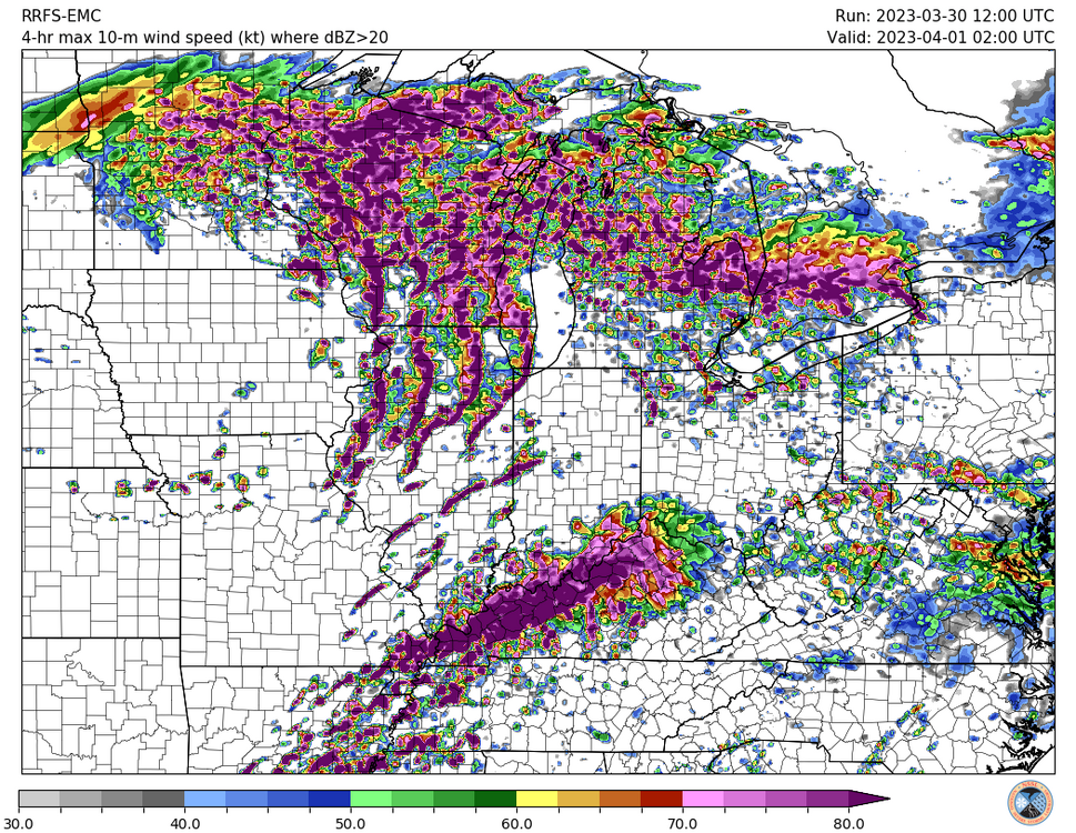
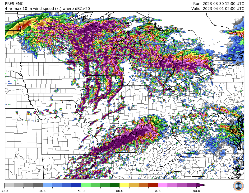
Just don't feel good about the potential for north-central / northeast Illinois. Taking models verbatim, we have potentially widespread, potentially strong storms plowing through the area in the morning hours, almost totally overcast skies through the balance of the day, and yet somehow we still end up with over 1000 j/kg CAPE? I get the very impressive dynamics of the system, including similarly-impressive unstable air advection on northwards, but a daytime high in the area somewhere in the low/mid-60s with extensive cloud cover and substantial early-morning convection never feels very good.
Assuming model guidance is right and I'm dead-wrong (more likely than not), though, I'm super concerned about damaging winds in the Chicagoland area. Storm movement per LOT potentially over 60 MPH plus the aforementioned dynamics of this system lead to some eye-watering images like this ... maximum 4-hour swath 10m winds showing pretty large swaths of >80 knot (~92 MPH) winds with this line. Pretty much a worst-case scenario type of graphic, of course, but does give a sense of what mets & others here have discussed re: significant severe potential.
Northeast IL/Chicagoland sure, north-central IL is definitely in a fairly high threat area though.
-
When the 3 km NAM comes in looking like the hyped up runs of the FV3/HRRR, you might have a problem. 18z run is crazy for the northern MDT/vicinity.
-
1
-
-
4 minutes ago, Chambana said:
Forgive my amateur question pertaining to severe wx, but could this be the highest threat to the region since 4/27/11?
I won't make any comparisons to such high end outcomes this far out, but the synoptics with this one are screaming major severe weather outbreak, to say the least. Still comes down to the mesoscale on the day of and day before, but the potential here is at a level rarely seen given the consensus from the 12z guidance.
Putting it another way for the long-timers, back in the day, this would be a level of threat that @CUmet would come out of the woodwork for.
-
1
-
 5
5
-
-
Just now, SolidIcewx said:
Now imagine if this was May/June
Lol you don't have to imagine it, there's 2000-4000 CAPE across the entire warm sector with tornadic supercell wind profiles.
-
8
-
2
-
-
Unbelievable run again. All of those are occurring in environments favorable for strong/violent tornadoes.
-
1
-
-
Put it this way, I would be in favor of moving Tuesday's thread to the main board if this place wasn't so poorly organized. Feel like both C/W and GL/OV are going to be involved in some manner here.
-
1
-
 1
1
-
-
These are some of the most dangerous model solutions I've seen in a very long time within reasonable range.
-
3
-
-
30% D6 issued, with some pretty strong wording (understandably) for being that far out.
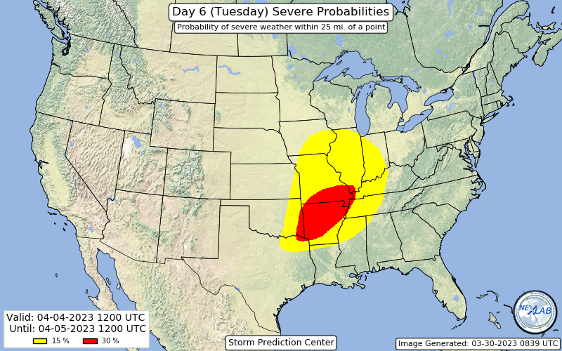 Quote
QuoteAs the western trough ejects on Day 6/Tuesday, potential significant severe thunderstorms will be possible far eastern OK toward southeast MO and vicinity. Rich boundary-layer moisture will be in place amid steep midlevel lapse rates courtesy of an EML advecting across the region from the Mexican Plateau. This will supply plenty of instability with stronger vertical shear accompanying the ejecting trough. There is some uncertainty among medium range guidance on the northern extent of better moisture return and hence severe potential. This is mostly driven by differences in surface low, dryline and warm front positions related to somewhat different ejection of the upper trough. However, guidance is in very good agreement with respect to the southern portion of the risk area. Supercells capable of all severe hazards, some potentially significant, will be possible.
-
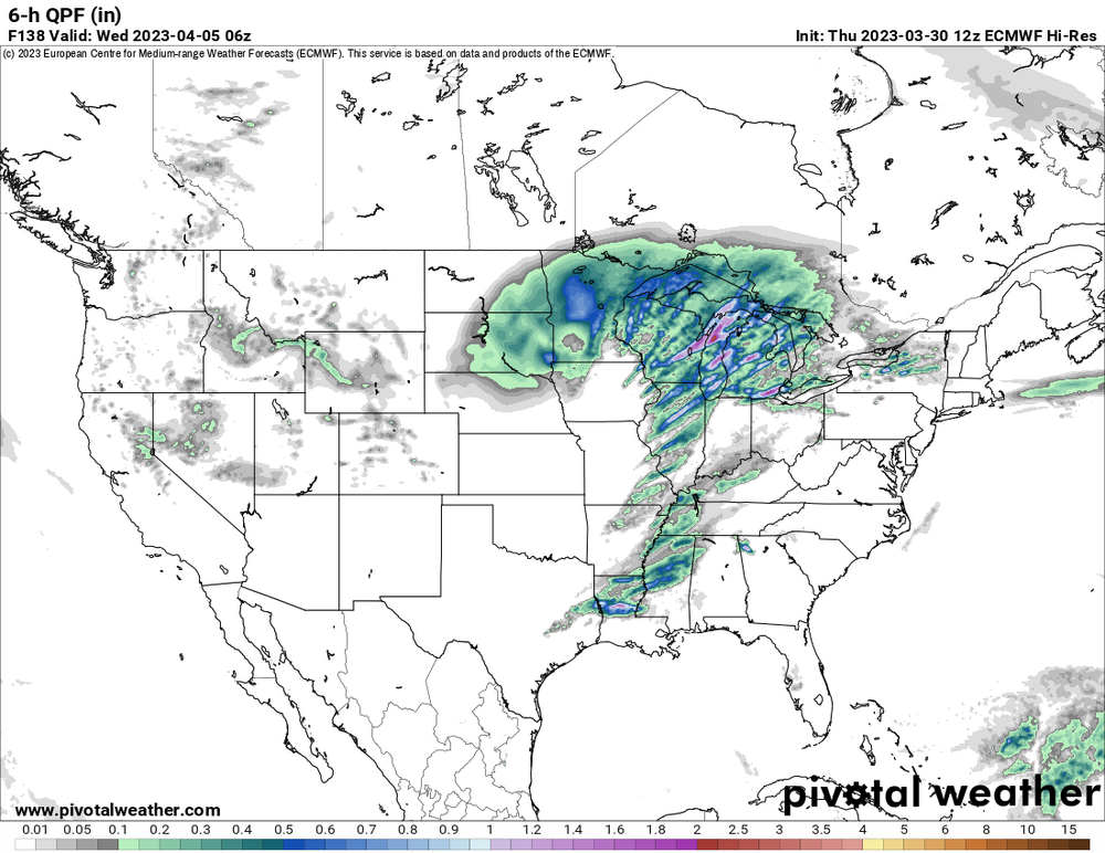
Euro once again is a high end event for 4/4 (Tuesday). Massive trough with a wavelength of more than half the CONUS slams into a huge warm sector with mid-upper 60s dewpoints throughout. Other models definitely slowed so there is a bit of split now in the solutions.
-
2
-
-
Bimodal D2 MDT, one closer to the surface low with a 10 hatched tornado risk (wind driven), the other in the Mid South with a 15 hatched tornado risk.
QuoteDay 2 Convective Outlook NWS Storm Prediction Center Norman OK 1257 AM CDT Thu Mar 30 2023 Valid 311200Z - 011200Z ...THERE IS A MODERATE RISK OF SEVERE THUNDERSTORMS ACROSS EASTERN IOWA INTO NORTHWEST ILLINOIS...AND ACROSS NORTHEAST ARKANSAS...THE MISSOURI BOOTHEEL...EXTREME WESTERN KENTUCKY...WESTERN TENNESSEE...AND FAR NORTHWEST MISSISSIPPI... ...SUMMARY... Intense and widespread severe thunderstorms are expected Friday afternoon into the overnight hours across portions of the Middle Mississippi Valley and Mid-South vicinity, eastward to the Lower Ohio and Tennessee Valleys. Intense, damaging gusts and several tornadoes (some strong and long-track) are expected. ...A bi-modal regional outbreak of severe storms is expected on Friday from the Mid-Mississippi Valley into the Mid-South... ...Synopsis... An amplified large-scale upper trough will be oriented from the northern plains to the southern Rockies early Friday. The trough will continue to deepen as it shifts east toward the MS Valley by 00z, and oriented from the upper Great Lakes to the TN Valley vicinity by Saturday morning. With time, a closed low is expected to develop over eastern SD/NE/IA and a 100+ kt 500 mb jet will overspread the Mid-MS/OH Valley region. Intense southwesterly low-level flow also will overspread the Mid-South through much of the Midwest, with an 850 mb jet around 65-80 kt forecast by late afternoon into the overnight hours. At the surface, a deepening low centered over eastern NE/western IA Friday morning will shift east across IA through the afternoon before lifting toward southern Ontario overnight. A trailing cold front will extend from the low into eastern KS/central OK/west-central TX at 12z, and shift east across much of the Midwest and Mid-South. Ahead of the eastward-advancing front, strong southerly flow will transport 60s F dewpoints northward. Near-60 F dewpoints are expected as far north as eastern IA into northern IL during the afternoon. The warm sector will become more narrow/pinched off with north and east extent toward the Ohio Valley during the evening/overnight hours. However, near 60 F dewpoints are still expected in a narrow corridor ahead of the surging cold front into far southern IN and central KY. Richer boundary-layer moisture will reside from the Mid-South into the Lower-MS/TN Valleys where low to mid 60s F dewpoints are forecast. ...Mid-Mississippi Valley Vicinity... The strongest forcing/DCVA will be located over northern portions of the Mid-MS Valley close to the surface low/triple point. The expectation is that rapid destabilization through the morning (1000-2000 J/kg SBCAPE) and arrival of stronger forcing by early afternoon will result in initial supercell development near the surface low. All severe hazards will be possible with these fast moving storms, including a couple of strong tornadoes, intense damaging gusts and large hail. Cellular activity should spread across eastern IA/northern MO and into northwest IL before tendency toward upscale growth into linear convection ensues with eastward extent as convection develops south and east ahead of the front from east-central MO into northern/central IL. Damaging gusts will become more prominent with linear convection, though QLCS tornadoes will also be possible. Additional storms will likely form near/just north of the warm front and move into parts of far southeast MN and southern WI. This activity should remain elevated, posing a risk for large hail and strong gusts, though any cell rooting on the warm front will pose a tornado risk as well, though the better warm sector is expected to remain south of MN/WI. ...Mid-South Vicinity... A concerning scenario appears to be developing across portions of the MO Bootheel, northeast AR, western TN/KY and far northwest MS vicinity during the afternoon/evening. At least mid-60s F dewpoints are expected beneath modest midlevel lapse rates. This will support 1500-2000 J/kg MLCAPE amid intense vertical shear. Forecast soundings indicate 0-1 km SRH increasing to around 400 m2/s2 by early afternoon. Thunderstorms are expected to develop by early afternoon ahead of the cold front within a pre-frontal trough/low-level confluence zone. Storm motion near 50 kt with supercell wind profiles will support cells capable of significant and long-track tornadoes. With time, upscale growth into a QLCS is expected, and intense wind gusts will be possible in addition to mesovortex tornadoes. ...OH/TN Valley vicinity... Low-level moisture/instability will begin to wane with north and east extent into the nighttime hours. However forecast guidance has consistently shown a few hundred J/kg MLCAPE with little/no inhibition. Forecast guidance generally tends to under-forecast north/east extent of severe potential in strongly forced, intense shear system. As such, the ongoing outlook maintains a broad gradient from Enhanced to Slight risk across this region. Damaging gusts and a few QLCS tornadoes will be possible into the nighttime hours. ..Leitman.. 03/30/2023
-
Predictably, the 00z HRRR is insane.
-
2
-

March 31st Severe Threat
in Lakes/Ohio Valley
Posted
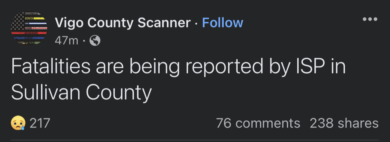
2 dead in Sullivan IN per police thus far.