BullCityWx
-
Posts
8,924 -
Joined
-
Last visited
Content Type
Profiles
Blogs
Forums
American Weather
Media Demo
Store
Gallery
Everything posted by BullCityWx
-
UKMET had an increase at 0z over 12z yesterday, fwiw.
-
Looking at the 6z NAM, we're clouded over here before Saturday even begins. The more we can limit sunlight that day, the better. With CAD already starting from the high, that could mean temperatures are cooler on Saturday and thus you get a lower wet bulb that evening or night. and yes, this is a time where I think this could absolutely matter.
-
I think maybe for the airport and south/east you're right. For me, you and sean who are on the NW fringes of the metro, I feel much better.
-
1000% agree there. I dont know where the freezing rain area sets up but where it does, ouch.
-
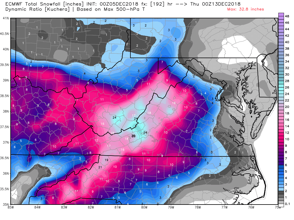
I dont think this is an awful comparison
-
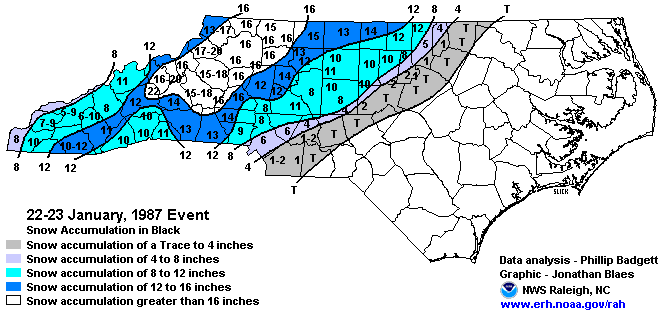
I could also see a january 1987 sort of situation.
-
RDU looks similar but a little less. An inch less on the means.
-
Checked my soundings through 6z on Monday on this GFS run. Looks like it SHOULD be all snow through then, if the model is right.
-
Almost reminds me of that February 2015 storm.
-
Thank you for that, matt. Also my pet peeve.
-
6z GEFS Snow means for Chapel Hill: Down to zero whiffs. 7/20 show single digits but nothing below 3" 4/20 show 10-12" 9/20 show 12"+ Of those 9, 3 show 20"+
-
Boy the FV3 looked good. Someone is gonna get smacked by that deform band on Tuesday, if it's real.
-
Southeast Sanitarium - A Place to Vent
BullCityWx replied to Jonathan's topic in Southeastern States
Is this where I come to complain about my massively increased totals on the 6z GFS? -
Ha! Still shows 6-7” from Clemson to Gaffney. With all the hemming and hawing, I would’ve thought opposite.
-
It’s not only the numbers, it’s the widespread support for big snow.
-
13/20 GEFS members have double digit totals.
-
Snow numbers up, too.
-
Surface reflection on the ICON is south of 12z at 78.
-
Southeast Sanitarium - A Place to Vent
BullCityWx replied to Jonathan's topic in Southeastern States
Yeah man, of course. I still have lots of people back that way so I try to stay up on it. -
Southeast Sanitarium - A Place to Vent
BullCityWx replied to Jonathan's topic in Southeastern States
I mean the EURO EPS number actually increased at IGX last run. I'm still learning this area and it's forecasting quirks but I really do feel okay about my location. -
Southeast Sanitarium - A Place to Vent
BullCityWx replied to Jonathan's topic in Southeastern States
Yep, started work at Duke this summer. Actually I dont think where I live looks too awful as I'm in far west Durham County. -
Southeast Sanitarium - A Place to Vent
BullCityWx replied to Jonathan's topic in Southeastern States
I didnt know I was completely out of the running until just shortly ago. Oh Well. -
A certainty 120 hours out? I get the pessimism if I was talking about Johnston or SE Wake but I still think North and West Wake plus durham and a lot of orange are still in this.
-
And that 2002 storm had about two and a half inches liquid