BullCityWx
-
Posts
8,924 -
Joined
-
Last visited
Content Type
Profiles
Blogs
Forums
American Weather
Media Demo
Store
Gallery
Everything posted by BullCityWx
-
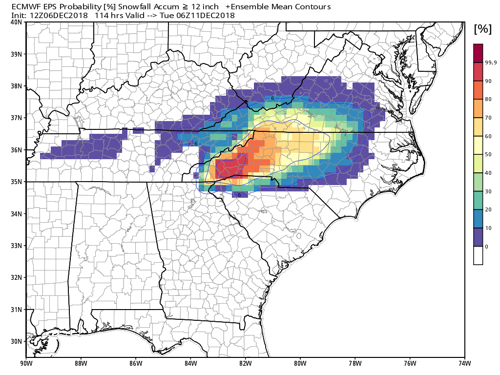
Mean snowfall for CLT on the SREF this run is basically unchanged, around 4.5"
-
It depends where in CLT. Ballantyne? No. Shuffletown or Mountain island? better shot.
-
I think it depends on how much snow or freezing rain. If it's either of those, you could see limbs breaking. Not so much with sleet.
-
Losing half an inch of QPF will do that
-
UKMET is really cold at the surface.
-
FV3 seems to really want to make US 74 the cut off, as per usual
-
I think we’re good here. A foot or more of snow falls over a large area before the assumed changeover happens.
-
Did anyone else notice the RGEM has QPF in NC as soon as 12z Saturday?
-
or panicking when one model shows a negative solution. Some people irrationally use storm busts too.
-
GFS honestly isnt bad either. I'm thinking this NAM run will end up being fluky.
-
I will take that GFS run, gladly so.
-
9Z SREF Mean is double what falls at RUQ on the 12z NAM.
-
SREF has a mean snowfall of just about 5" in Charlotte by 7PM Sunday.
-
The NAM doesnt even agree with it's own ensemble members yall.
-
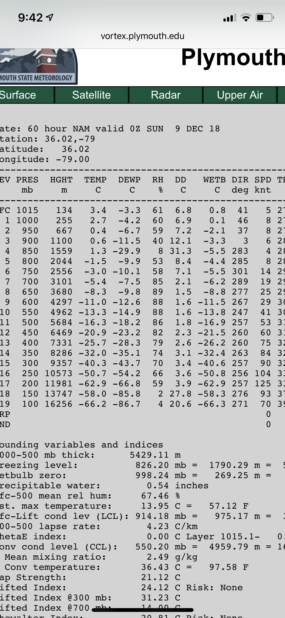
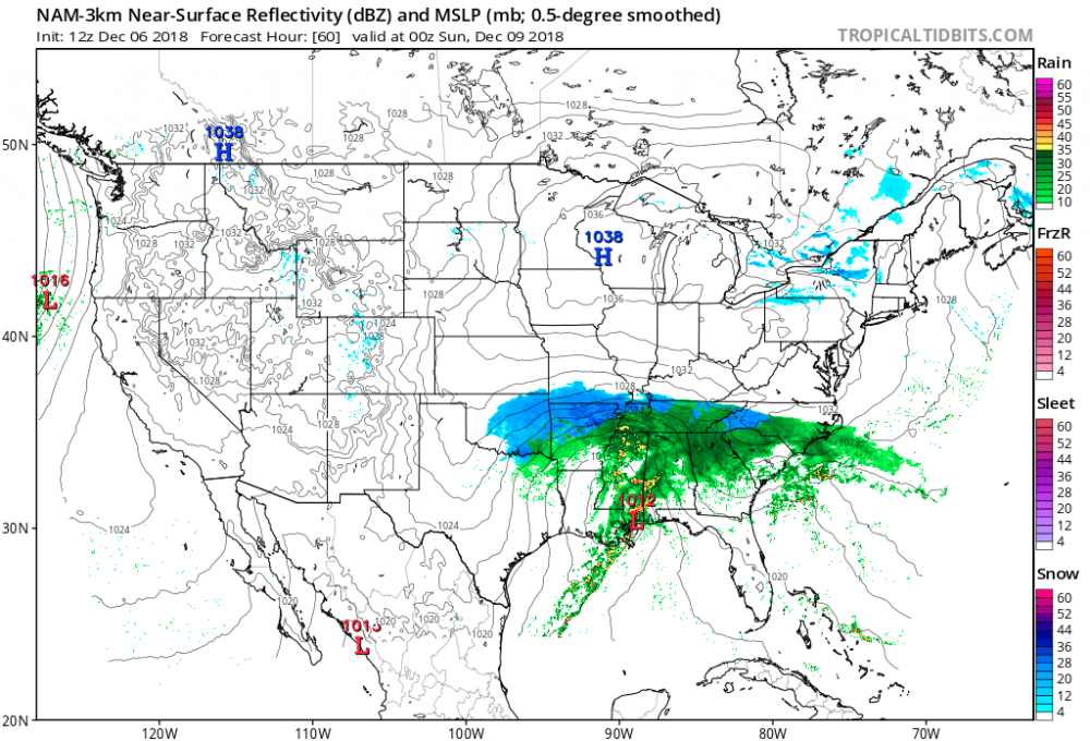
That is exactly my hypothesis. If you look at the 3K, at Hour 60, you see the snow line advancing because there's precip. On the regular NAM, you dont have anything that triggers dynamic cooling until we knew we'd start mixing anyway.
-
Extracted data is showing thunder sleet
-
I think you can argue that it’s doing what it’s been showing for a while now and cooling from the top down. It’s snowing just on the other side of the Catawba on that frame.
-
3K NAM has the snow line advancing southward at 60.
-
The usual suspects, every time.
-
Did you check the soundings? I’ll hang up and wait for your answer.

-
Does anyone check soundings anymore?

-
Just going on feel and experience from past storms: I expect the most snow to fall in the front end thump. If we see the generational totals advertised by several models, it's because it's going to snow like we've never seen before on Sunday before Midnight. If the front end thump doesnt work out, those totals dont work out. I fully expect this to start quicker than whatever the timeline ends up being, just from past events. There will be freezing rain and sleet mixed in almost everywhere, that I have no doubt about. I expect the most freezing rain from Athens to Columbia to Rocky Mount. I wouldnt be surprised to see this freezing rain line make it as far southeast as Florence to Bladen County up to Clinton and further NE. Most sleet will probably follow a line from Anderson to Rock Hill to Raleigh. Someone in that area could full well see half a foot of sleet. Surface temps are going to be at least 3-4 degrees colder than modeled now. N&W of that sleet line, especially the areas closest to the sleet line, will probably see the heaviest snow. Just my gut feelings based on what the models have shown and past experience.
-
I think the most critical thing for places like Charlotte, Raleigh, Greenville will be how much do you get out of the front end thump? That's where you're going to see the best snow growth. Once we get to 0z Monday, it seems like the soundings either dry out in that region or slightly go above freezing. I think what people dont remember about 1/1988, most of the snow fell in that event at the very beginning. The end was sleet and freezing rain. I could see a situation like that.
-
Ye olde town trash dump is probably a good divding line.