BullCityWx
-
Posts
8,924 -
Joined
-
Last visited
Content Type
Profiles
Blogs
Forums
American Weather
Media Demo
Store
Gallery
Everything posted by BullCityWx
-
Euro looks like another 3-4" tomorrow for Chapel Hill and Durham like @WidreMann mentioned. if it can manage to be pure snow, maybe 2-3" down around Charlotte and points S/E of the city.
-
And the HRRR nailed the snow line damn near 36 hours out. Outstanding.
-
Has a convective look on the HRRR
-
ICON looks like at least another 2-3” on Monday
-
18z GFS has me all snow until tomorrow at 18z. We’ll see.
-
ICON had the same thing at 12z with second round
-
Tomorrow is gonna be about rates, too. Heavier the snow earlier on the better chance it holds on just a little longer.
-
Looking at the soundings for MBY(pretty much just south of 85 on the orange/Durham line), it holds the snow sounding longer than last run on the NAM.
-
Man, I am so jacked for you. Good luck!
-
That’s some fine science you’re doing right there
-
The GFS is not only isothermal IMBY but safely so. I really am skeptical to trust it’s thermals but it’s had support from the HRRR/RAP/Euro/ICON so who knows
-
SREF Mean up to half a foot for RDU and 10” for Roxboro. 8” looks like a good call for Durham.
-
@Poimen, I’ve been watching the ICON closely since it did so well last year. It’s slowly gone colder the last three runs and this run is the best yet.
-
Have to like this run if you’re in Chapel Hill or Durham
-
Modeling does take moistening the atmosphere into effect
-
18z ICON extracted data keeps MBY as snow until about 7PM on Sunday. It’s close, real close, to the transition line. You gotta smell the rain I’m telling myself.
-
For those of y’all who are curious about gulf convection, you don’t want a horizontal (—)line across the gulf. If the storms are lined up like this (/) it can actually add to moisture.
-
GFS looks like all snow IMBY through 48.
-
Climo
-
Yeah, I’m thankful to just at 85 tonight
-
Check please
-
Garbage. They are total garbage. I don’t get why anyone would use them.
-
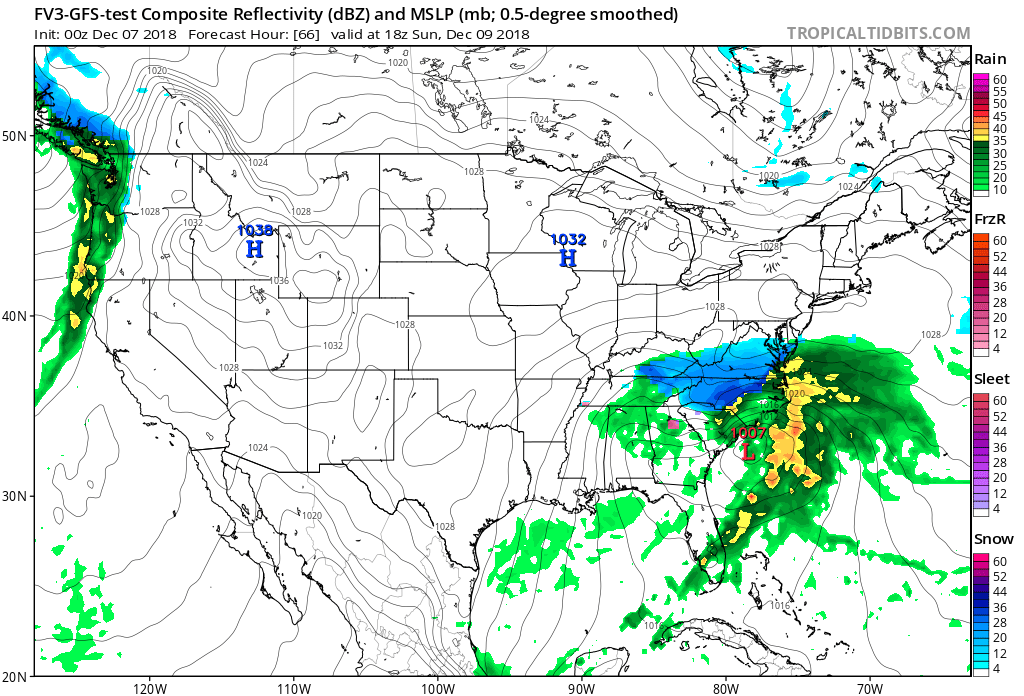
Pretty sure the FV3 just put down 2 feet somewhere across the southern piedmont.

-
You’re so needy. Really digging the trends today. We had one bad model run and the NAM seems to be slowly coming back.
-
Southeast Sanitarium - A Place to Vent
BullCityWx replied to Jonathan's topic in Southeastern States
No but sometimes Lake Norman has been rumored to have influence