Radtechwxman
-
Posts
2,099 -
Joined
-
Last visited
Content Type
Profiles
Blogs
Forums
American Weather
Media Demo
Store
Gallery
Everything posted by Radtechwxman
-
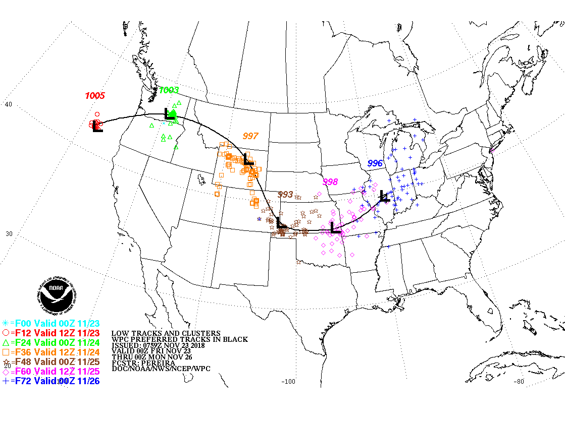
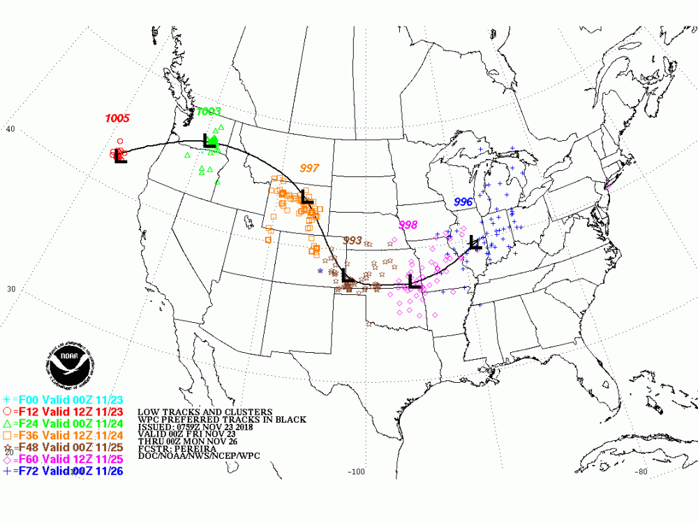
Nov. 25th-26th Midwest Snowstorm Potential
Radtechwxman replied to Malacka11's topic in Lakes/Ohio Valley
This is madness. Still two distinct model camps. Hope 12z has better consensus. I still think GFS is too north. And 12km nam may be too south. A compromise is best at this point -
Nov. 25th-26th Midwest Snowstorm Potential
Radtechwxman replied to Malacka11's topic in Lakes/Ohio Valley
LOL. My exact thoughts. Thought it was only 12z and 0z -
Nov. 25th-26th Midwest Snowstorm Potential
Radtechwxman replied to Malacka11's topic in Lakes/Ohio Valley
Makes sense. Guess only time will tell. I feel like a NAM/EURO compromise is best atm -
Nov. 25th-26th Midwest Snowstorm Potential
Radtechwxman replied to Malacka11's topic in Lakes/Ohio Valley
This is very strange. GFS and Euro totally flip flopped. Haven't had chance to look in depth but is Euro more open aloft with the wave? -
Nov. 25th-26th Midwest Snowstorm Potential
Radtechwxman replied to Malacka11's topic in Lakes/Ohio Valley
Have a feeling euro will cave shouldn't have got my hopes up after 0z runs last night. Looks like 12z runs had a partial sampling. 0z runs should have a full sample. Maybe the wave is going to be stronger than anticipated -
Nov. 25th-26th Midwest Snowstorm Potential
Radtechwxman replied to Malacka11's topic in Lakes/Ohio Valley
-
Nov. 25th-26th Midwest Snowstorm Potential
Radtechwxman replied to Malacka11's topic in Lakes/Ohio Valley
Yea that's critical to whether this hooks north quicker vs a more open wave with a more gradual NE turn -
Nov. 25th-26th Midwest Snowstorm Potential
Radtechwxman replied to Malacka11's topic in Lakes/Ohio Valley
When does the next euro run start coming out? -
Nov. 25th-26th Midwest Snowstorm Potential
Radtechwxman replied to Malacka11's topic in Lakes/Ohio Valley
Hence why I call GFS goofus. If 12z euro takes a big jump north I will be more inclined to believe it. My gut is just saying a track pretty much along I70 and taking a more northerly turn in Indiana. GFS is so north with the low and seems to hook north almost in NW IL. That's a drastic change -
Nov. 25th-26th Midwest Snowstorm Potential
Radtechwxman replied to Malacka11's topic in Lakes/Ohio Valley
Wouldn't be getting excited over one run. Lol. Gfs was the most southern outlier for days and now it did a 180 and is the most north with low. I think a track closer to I70 is more likely -
Nov. 25th-26th Midwest Snowstorm Potential
Radtechwxman replied to Malacka11's topic in Lakes/Ohio Valley
Model chaos ftw. Naturally euro would cave to gfs and get my hopes up and now gfs shifts way north. This is going to be a long few days. When do we get sampling? Hope that helps. Curious to see if Euro holds on 12z run or if it budged north again -
Nov. 25th-26th Midwest Snowstorm Potential
Radtechwxman replied to Malacka11's topic in Lakes/Ohio Valley
Thanks a bunch! Wow that caved big time to gfs. Curious to see if this trend holds or if models will nudge back north after sampling -
Nov. 25th-26th Midwest Snowstorm Potential
Radtechwxman replied to Malacka11's topic in Lakes/Ohio Valley
Can anyone post the 0z euro snow map? -
Nov. 25th-26th Midwest Snowstorm Potential
Radtechwxman replied to Malacka11's topic in Lakes/Ohio Valley
Definitely a notable se trend. Gfs is obviously on the extreme end of guidance for it's southern track. But curious to see if other models keep nudging se -
Nov. 25th-26th Midwest Snowstorm Potential
Radtechwxman replied to Malacka11's topic in Lakes/Ohio Valley
GFS has been relatively consistent the last 3 runs. But a far cry from other models. The system is not adequately sampled yet so major changes are still possible. Someone is going to get dumped on and get some near blizzard conditions -
2018 Short to Medium Range Severe Thread
Radtechwxman replied to tornadohunter's topic in Lakes/Ohio Valley
Imo the better threat looks to be shifting west due to ongoing mcs in Indiana. This will keep cloud debris persistent across Indiana and western Ohio. More broken cloud pattern in Iowa and Illinois so enough sun to promote instability. Hrrr is consistent on bringing a squall line into western IL around 5-6pm and has some discrete activity forming ahead of it. I think IL could be more in play for a tornado threat than further east. DVN also mentioned some wave in SW Iowa could help to back winds more later -
Major Hurricane Florence: STORM MODE THREAD
Radtechwxman replied to stormtracker's topic in Tropical Headquarters
Wow yea infrared just blew up in the nw quadrant -
Major Hurricane Florence: STORM MODE THREAD
Radtechwxman replied to stormtracker's topic in Tropical Headquarters
Has to be pretty rare to have a cat 1 with a pressure this low -
Major Hurricane Florence: STORM MODE THREAD
Radtechwxman replied to stormtracker's topic in Tropical Headquarters
TWC just reported that Beaufort gusted to 99mph -
Major Hurricane Florence: STORM MODE THREAD
Radtechwxman replied to stormtracker's topic in Tropical Headquarters
Looking at the infrared loop almost look like it is stalling now -
Major Hurricane Florence: STORM MODE THREAD
Radtechwxman replied to stormtracker's topic in Tropical Headquarters
Def looks better on microwave. Yea that friction could def help tighten it up. We saw that with early stages of Gordon on Floridas west coast -
Major Hurricane Florence: STORM MODE THREAD
Radtechwxman replied to stormtracker's topic in Tropical Headquarters
That inner eyewall is looking pretty unimpressive on radar. These outer rain bands look more potent -
Major Hurricane Florence: STORM MODE THREAD
Radtechwxman replied to stormtracker's topic in Tropical Headquarters
Yea the size will hinder winds coming up. If the pressure drops the energy will be spread out over such a large area -
Major Hurricane Florence: STORM MODE THREAD
Radtechwxman replied to stormtracker's topic in Tropical Headquarters
Is that normal or is there issues? -
Major Hurricane Florence: STORM MODE THREAD
Radtechwxman replied to stormtracker's topic in Tropical Headquarters
Curious to see an updated microwave image. To see if an EWRC is occurring with those concentric eyewalls present