
Radtechwxman
-
Posts
2,481 -
Joined
-
Last visited
Content Type
Profiles
Blogs
Forums
American Weather
Media Demo
Store
Gallery
Everything posted by Radtechwxman
-
Definitely the best Zeta has looked since it came off the Yucatan. Major convective burst that's trying to wrap around the LLC. Curious to see how strong it will get the next 24hrs while it's in the best conditions for strengthening
-
That certainly has dropped from earlier and honestly not surprised given how it looks
-
My exact thinking. The circulation is broad and the core took a hard hit over land. On visible the LLC can be seen pretty exposed. Zeta has a lot of work to do. Dry air really has worked in. It definitely has ripe conditions for strengthening but will it organize in time to take advantage of the environment. I'm feeling doubtful with it's current structure and lack of very deep convection near LLC. Only time can tell but I agree if this were better organized a more significant hurricane would be possible but imo the ceiling is probably a strong cat 1 unless it rapidly gets itself together tonight.
-
Well NHC had the intensity at cat 3 but probably wasn't looking at the satellite and wind data. Guessing it will landfall at 100-105
-
Carl Parker on TWC just said hurricane hunters getting much lower winds than 115mph in northern eyewall. Guessing we see a downgrade to cat 2 at 1pm
-
Shear isn't even to it yet. Just normal fluctuations in convection. Delta will be outrunning the better oceanic heat content soon
-
By far best Delta has looked its whole life
-
120mph 955mb now
-
Any hurricane hunters heading to Delta or currently in Delta? Curious to see some wind data
-
Neither Laura or Michael were remotely half-a-cane. May want to go recheck satellite images
-
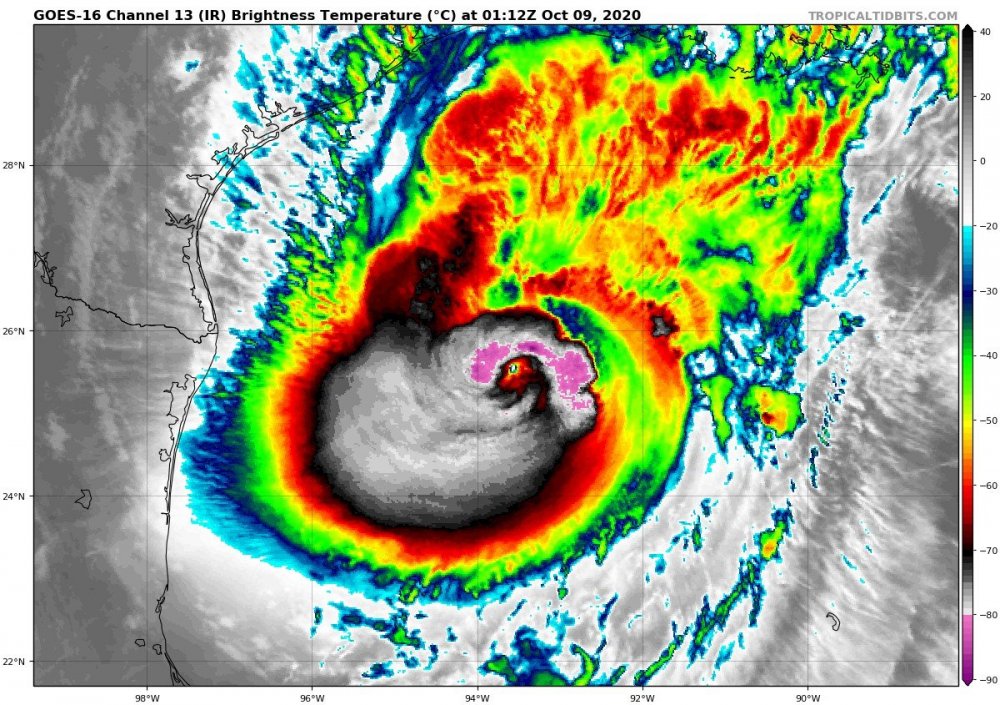
Delta looking real cute now. Finally a legit eyewall surrounding entire eye. Guessing we will see a bump up in intensity at 11pm advisory
-
Nice ring of convection blowing up in eastern eyewall now
-
Looking at water vapor seems like some drier air has impacted the NE quadrant. This could be a reason the convection isn't as robust. Seems like our eye has become obscured again. Not sure we're going to hit 125 like NHC is forecasting. Curious to see what Delta does as we approach the convective max time.
-
Still seems like eastern side of storm hasn't taken off as much as western side. Cloud tops much colder in western semicircle. I see NHC is forecasting it just shy of cat 4 before the weakening starts. Have it landfalling as a major cane now.
-
Seems like the east side is struggling to get the really cold cloud tops to stay. Good banding to the north and northwest but definitely lacking east. Delta still looks much better though than it ever has
-
Literally this! Lol. Hilarious. Can't analyze frame by frame. Delta is organizing. It will look good at times then bad at times. This isn't going to look like Laura
-
Definitely best Delta has looked. Even when it was high end cat 4. Eye popping on infrared and visible
-
Not saying you're wrong because that's a distinct and likely possibility. All comes down to what it does tomorrow. Just was saying it's a possibility, what I said. Very odd hurricane. It has maintained very impressive convection but has lacked to really get a strong defined core likely because of the shear.
-
I have a degree in meteorology. I understand man. I'm talking about it getting stronger the next day or so in the more favorable conditions. If you end up with a stronger storm in the short term, you will likely have it landfall stronger. Yes it has plenty working against it as it nears landfall but a well formed core of a strong hurricane just won't instantly degrade. Yes there will be weakening but with a larger circulation developing as were already seeing. That won't break down as fast as Delta did prior to landfall in Yucatan when the circulation was much smaller. It all depends on what happens while the environment is ripe for intensification
-
NHC hitting the weakening pretty hard prior to landfall. Based on it's organization tonight, I think it could overachieve current intensity forecasts
-
Oof. New advisory has Delta down to 85mph. Man model guidance has been all over for this. NHC forecasting a high end cat 2 to low end cat 3 landfall now
-
Seems like when shear is forecasted it doesn't pan out and when it isn't forecasted it appears. Delta looks very rough now. Cloud tops have remained very cold but inner core is just so sloppy. Can't recall a high end cat 4 ever with no eye visible
-
This is the ugliest 145mph hurricane I ever laid my eyes on via satellite. Lol. I'm shocked the winds went up. Only in 2020. Despite it being disorganized in the inner core, it still has took advantage of the great environment conditions.
-
Yea if someone showed me the current IR satellite loop and ask me to guess intensity I definitely wouldn't be saying cat 4. Curious if the pressure has come up more and if the winds are lower. Cloud tops still very cold but organization is poor.
-
That's a valid point. Not often you see a pressure rise correspond with a decent uptick in winds