

cyclone77
-
Posts
17,685 -
Joined
-
Last visited
Content Type
Profiles
Blogs
Forums
American Weather
Media Demo
Store
Gallery
Posts posted by cyclone77
-
-
Was just looking back at my records and saw that we had our first flurries of the season on October 4th 2014. Those were the earliest flakes I've seen since I've been alive. October 4th is less than 3 weeks from now, so it's kind of mind boggling that it can theoretically snow in the not-so-distant future.

-
1 minute ago, Hoosier said:
90 at MLI again. Where's cyclone to celebrate?

Hey I was actually just about to quote your previous post lol. Yeah another one today makes for the 35th of the season. Hit 87 here today, and 89 yesterday. Really didn't feel uncomfortable though, as the dews have only been in the low to mid 60s, with a decent breeze. What a difference mid 60 degree dews can make compared to the never ending 70s from before.
Even with all the rain we've received in the past 3 weeks, the crops have really browned up and dried out over the past 10 days. There's already lots of harvesting (corn) going on, which is pretty early for that. I'm guessing since the corn was WAY ahead of schedule earlier this summer the crops are drying out earlier for the same reasons.
-
Looks like Gordon's remnants will track where pretty much all tropical remnants seem to track. Downstate IL through IN/OH and points east. It's always fun to entertain the possibility of seeing tropical remnants this far north/northwest when the medium-range guidance repeatedly shows that scenario, but it's pretty hard to take it serious unless the threat remains within 60hrs. Seems like these things always pull more towards the right compared to what's modeled in the mid-range.
-
 1
1
-
-
22 hours ago, hawkeye_wx said:
This was pretty darn close to my house, 0.7 miles to my nw. I guess it's a good thing this cell veered north a bit as it approached.
Damn that's a little too close for comfort! Especially with no warning.
-
1
-
-
As expected Gordon's remnants will miss this area well to the southeast. Very unusual to get tropical remnants this far nw. I'd say maybe once in about 10 years estimating.
Despite the rather ominous potential that this latest round of rains presented we came out with about the perfect amount of rain. Just under 2" since Saturday. Looking forward to the break in the heat and humidity in the next few days.
-
1
-
-
91 at MLI today made the 33rd 90+ day for 2018.
-
Looks like DVN confirmed an EF-1 on the west side of Cedar Rapids. IIRC that storm wasn't tornado or severe warned.
-
1
-
-
Picked up 1.23" of rain last night and today. About a half inch of that fell in about 6-7 minutes last night as a very heavy cell went through. You can definitely see how some areas have picked up excessive amounts after seeing rainfall rates like that. One of the cells that went over today (which eventually went on to drop the birdfart nader near Rockford) exhibited supercell characteristics as it passed just to the northwest.
Regarding Gordon's remnants later this week I've been pretty much expecting models to start shifting southeast with the track of it, as it's very unusual to see remnants this far northwest. Looks like the trends have already started. Although with as weird as this year's weather has been it still wouldn't be all too surprising to see such a northwest track like the Euro and GEM had been showing.
-
Picked up 0.67" from yesterday morning's storm complex. The storms last eve stayed just to the north but put on a hell of a light show. It was enough to even knock the power out for a short time as a barrage of CGs skirted a bit north of town.
Think the best shot at heavy rain will be north and west of the QC tonight, but it's close enough we'll have to keep an eye on it.
-
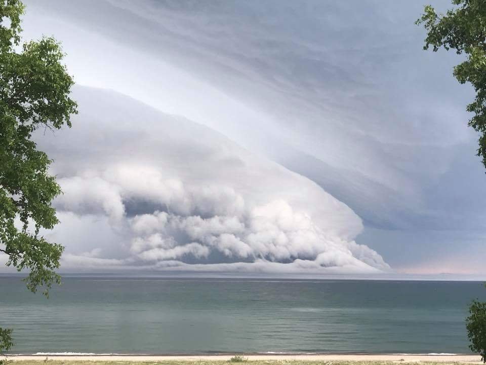
Severe storm quickly rolling in earlier.
-
2
-
-
40 minutes ago, Indystorm said:
Look out Cyclone. Tor warning just across the river from you in IA moving ne. Radar confirmed near Grand Mound
That was the best storm here in quite a long time. Incredible multi-tiered gust front, with the lower clouds practically scraping the earth as it marched in very quickly. Had a period of 50-60mph winds and blinding rain. Rain gauge says we got a little under a half inch, but I'm guessing quite a bit of it blew over the rain funnel lol.
The growing concern now is the convection in southern IA/northern MO. The LLJ is going to feed those puppies all night, so where the storms eventually align is going to be in for a lot of rain. Still too early to tell where that will set up exactly, but it looks like southeast IA up towards the 80 corridor east of the QC.
-
2
-
-
Quite a nice synoptic wave moving through for late August. Looks like southern Iowa is starting to recover quite rapidly now as the WAA stuff has lifted out quite quickly. Nice plume of steep mid lapse rates upstream coming in from the Plains should quickly re-destabilize central and southeast IA by later on today. Definitely expect a nice round of convection or two after the current one overhead moves out. Could be quite an active night. DVN has gone with a FFW for the whole CWA, which is prob a good idea. If there's some training of storms like what was seen last night in WI someone in the DVN or LOT CWA may be in for a rough night lol.
-
2
-
-
A little snippet from the DVN AFD back on this day in 2011. Can't even fathom something like this being written now with how slow this year has been. Almost doesn't seem possible.
. SHORT WAVE COMBINED WITH FRONTAL
BOUNDARY AND HIGH CAPES SUGGEST POTENTIAL FOR EXPLOSIVE DEVELOPMENT
OF THUNDERSTORMS IF CAP BREAKS. IF THIS SCENARIO PANS OUT THEN A
DESTRUCTIVE DERECHO WITH WINDS OVER 100 MPH IS CERTAINLY POSSIBLE.
CORFIDI VECTORS WOULD TAKE THE THUNDERSTORMS SOUTHEAST ACROSS MUCH OF THE DVN CWA.-
2
-
-
1 hour ago, Hoosier said:
That looks like the old school TWC graphics. Who knew that they're still in use.
http://weatherdaddy.us/weatherdaddy/index.html?q=61265&makeDefault=on
-
23 minutes ago, BuffaloWeather said:
Anyone here do any lake fishing? We caught our limit of 18 walleye in 5 hours in Erie today. Including a 8 lb monster!

Nice, that will make for a real nice fish fry.

-
1
-
-
4 hours ago, snowlover2 said:
Think it's 1,033 for GRR and 1,059 for DTX or are you trying to be funny?
-
 1
1
-
-
48 minutes ago, outflow said:
Marquette back at 0 with today's watch. The streak of the lack of severe weather in lower mi is really quite remarkable
Wow, poor lower Michigan has gone over a million days without a tor watch. Brutal.
-
1
-
2
-
-
47 minutes ago, Stebo said:
View from Grand Marais earlier.
Very nice shot!
-
2 hours ago, Chicago Storm said:
Classic ridge riding derecho today.
Yep. Started way out in western NE about this time last night. Still going (although not severe anymore) and entering northern Mississippi.
-
46 minutes ago, Hoosier said:
St. Louis area getting hammered.
That complex is plowing right through that extreme surface moisture axis. SPC meso analysis shows PWs over 2" all along that axis, so rainfall rates are likely exceptional with that line.
-
1 minute ago, Hoosier said:
One thing I've learned is that Knightking has incredible dedication to wind chills.
Chillz fo thrillz yo
-
The coldest windchill by state thread needs to be renamed the zombie thread. The thread that will not die.
-
2
-
1
-
-
This is more long term, but the Euro has been pretty consistent in showing big cape over the corn belt/Midwest later next week. The 6000J/kg max value on WxBell is exceeded in some cases.
-
Maybe since late May and June has had a mid to late August type pattern when we get to August maybe we'll get an active May-June type of pattern.

-
1
-
1
-
September 2018 General Discussion
in Lakes/Ohio Valley
Posted
Yeah it'll be interesting to see if we can get a short break between snowfalls. Funny thing for me is the intense heat that hit early on, in May, and continued through June sort of wiped away that memory of the late snowfalls. We really flipped a switch between mid Apr and mid May.