

cyclone77
-
Posts
18,220 -
Joined
-
Last visited
Content Type
Profiles
Blogs
Forums
American Weather
Media Demo
Store
Gallery
Posts posted by cyclone77
-
-
Today will be the 13th 90 degree day here, and the 11th for MLI.
-
zzzzzzzzzzz
-
 1
1
-
 1
1
-
 1
1
-
-
8 hours ago, SchaumburgStormer said:
Yeah, definitely need something widespread, getting awfully crunchy around here and just waiting to get bumped to "severe" imby.
The numerous days above 90 with full sun definitely have sped things along.
-
Well in about 2hrs we'll officially close out the 24-25 snow season, and lock in the new all-time futility record at MLI with just 8.2". That beats what I always thought was untouchable old record of 9.9".
Would be awesome if we could go to the other extreme next season and achieve the most snowfall ever. That would be insanely cool to pull off.
-
3
-
-
The past few runs of the Euro show <1" or rainfall for the QCA through mid-July. Looks the drought monitor will be upping from abnormally dry to moderate drought by mid-month if trends continue.
-
 1
1
-
1
-
-
On 6/13/2025 at 9:21 PM, cyclone77 said:
Looking like 4+ inches of rain on the way over the next 10 days or so. May end up pushing double digit monthly rainfall totals for June if the pattern persists through late month.
Not even close.
-
23 minutes ago, CheeselandSkies said:
Kind of annoying that this active Northern Plains pattern hasn't really been able to move east in any meaningful fashion. Time was when eastern SD got tornadic supercells in the evening that meant we'd be getting a bow echo overnight.
Yeah mature MCS seem few and far between this year so far. Hopefully that changes in July and August. Ready 2 derecho.
-
1
-
1
-
-
Looks like rain chances very minimal now until next weekend around these parts.
-
Iowa's decaying mass of precip dumped 0.06" here overnight. That brings us to 3.51" for June.
-
Outflow boundary almost here. About to get some withering Iowa sloppy seconds.
-
1 hour ago, Chicago Storm said:
I know that I have brought this up a few times over the past couple of years, but it finally looks like it is going to happen...
NOAA sent out a TIN/PNS today regarding the decommissioning of the NAM (And other guidance) in favor of the RRFS. This change is currently set to occur in early 2026.
Has the RRFS been doing pretty well? I honestly haven't been paying enough attention to it as I probably should have lol.
Made 93 here, 91 at MLI today. Even with the indices up near 100 it wasn't too bad out there with the solid breeze today.
-
Just picked up a quick 0.35" from an isolated severe warned cell. Had a brief period of 45mph winds, and the temp has cooled down to 72 after hitting 93.
-
1
-
-
0.24" overnight.
-
I'd like to trade this ROF pattern in for a different one. This particular one is lame AF.
-
2
-
1
-
-
Non-productive clouds co ck blocked our temp potential today. Only made it to 84 here.
-
Picked up 0.00" of rain overnight and today here.
-
Another 93 today for MLI. Made it to 95 here though.
-
43 minutes ago, hawkeye_wx said:
The NWS forecast often has upper 90s during these heat waves, but we rarely get higher than low to mid 90s.
Yep. Some of the guidance has had dews mixing back into the 68-70 range by mid-afternoon, and that hasn't happened. The result is slightly lower ambients.
-
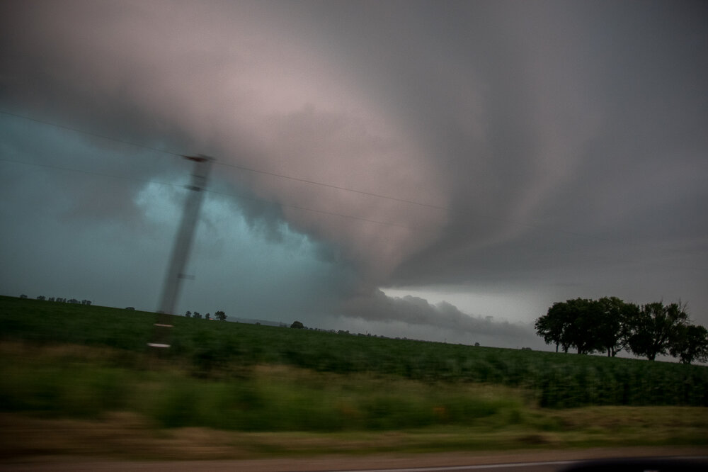
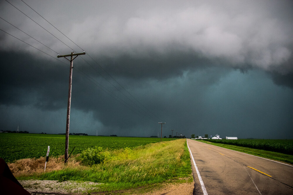
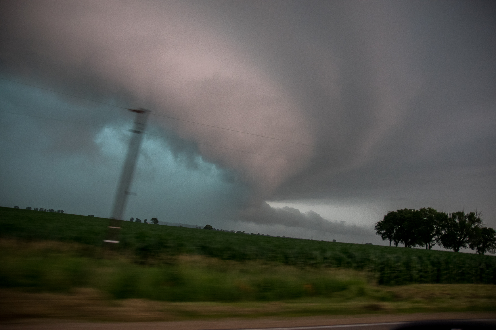
^ Remember that day as well. Followed it from the MS river to southeast of Sterling. Was on it while it was producing the Harmon tor in that area, but was wrapped up pretty good unfortunately.
-
5
-
-
Fairly lame heat wave for this area so far. Looks like temps today will only make the 93-94 range again. Dews not impressive as well.
I guess after achieving 120+ heat indices/83 dews many times, heat waves like this just don't impress lol.
-
1
-
-
Got down to a relatively frosty 75 here.
-
 1
1
-
-
Temps underachieved here today with only 93. Only 93 at MLI as well. Mid 70s dews pushed the index over 105 though.
Our hottest temp so far remains the 95 back on May 15th, although that was with much lower humidity.
-
Picked up 1.01" of rain here this week. Up to 2.84" for the month now.
Corn has really shot up. Most fields are waste high now, or higher.
-
1
-
-
Back home now. This air mass is a true slap in the face. A big wet slap in the face lol.

July 2025 General Discussion
in Lakes/Ohio Valley
Posted
Just had a 2 min period of large drop sprinkles. Top 5 event of the summer so far.