

cyclone77
-
Posts
17,663 -
Joined
-
Last visited
Content Type
Profiles
Blogs
Forums
American Weather
Media Demo
Store
Gallery
Posts posted by cyclone77
-
-
1.08" the total here
-
Pouring pretty nicely, up to 0.43" already. Should get over an inch with this which is pretty welcome.
-
 2
2
-
-
Just got Alek'd
-
 6
6
-
-
Hoping for a little thunder on Monday.
-
More than likely the seasonal snowfall total of 27.0" here will be the final total, as I don't see much chance going forward for additional snowfall.
68% of the season's snowfall fell within a 5-day period with 18.4" during that mid-January stretch.
Even though the total snowfall will end up being several inches below average the snowstorm on Jan 12th (13") made the winter. The extreme cold that immediately followed was icing on the cake. The rest of the winter was pretty benign from a winter storm tracking perspective, but at least we cashed in during the Jan stretch.
I guess I'd give this winter a B.
-
2
-
-
T of snow here.
-
1
-
 1
1
-
-
Several lightning strikes showing up with the heavy snow all along that band in Iowa.
So far just a 5 min period of sleet here, but should get a 1-2hr burst of wet snow later this morning.
-
Sleet pinging the eastern windows at the moment.
-
Gonna kind of seem like a northeastern US storm for the MSP area with heavy snow changing to rain after significant accumulation. Gonna get pretty sloppy pretty fast lol
-
May get a nice burst of wet snow around these parts around midday tomorrow, otherwise mostly a miss north.
-
A few passing flurry episodes this morning here.
We've had 2.3" of snow since January 13th.
-
41 minutes ago, CheeselandSkies said:
Eight years ago today, a localized tornado outbreak occurred across central Illinois. Synoptically the setup was pretty classic with the left exit region of the midlevel jet squarely over the area and a deep surface low. However marginal/"just-in-time" moisture was an expected issue with dewpoints only reaching the mid-50's by go time. However with cold air aloft and the excellent kinematics, it was enough. Although, my chase partner and I thought our tornado chances were done for the day when we pulled into the Casey's gas station on IL-116 at the west edge of Hanna City, ahead of the "tail-end Charlie" cell on the next cluster of storms north of the one that would produce the tornado just west of Springfield around the same time. The storm wasn't looking that impressive on radar and our plan was to gas up, get snacks and drinks, and let the storm roll over us, sheltering his car under the gas station canopy if there was hail and then shoot lightning on the back side on the way home (I never uploaded any of the video from before the tornado encounter until now, I'd forgotten how electrified the storm already was at that point).
It was at this point that several things happened in rapid succession. We felt a gust of warm inflow toward the storm still off to our immediate west (when, based on the prior radar presentation, we were expecting cool outflow), which should have been an "Oh s***!" moment but we just kind of shrugged it off "huh, that's interesting." What we didn't know was that the storm had just undergone a constructive cell merger. The radar updated to reveal, while not quite a classic hook on reflectivity, a definite RFD gust front curling back into an inflow notch, with an intense velocity couplet colocated with it, just off to our northwest! Both our cell phones alerted simultaneously with a WEA for a tornado warning, and the town's sirens blared to life! I'll let the video and its accompanying description tell the rest of the story...
I'm conflicted about counting this as my first tornado, since we weren't 100% sure of it in real time, and it cannot be confirmed from my imagery alone due to the intervening tree line at the ground. NWS ILX surveyed a 7.1 mile path of up to EF2 damage from northwest of Trivoli to north of Hanna City that matches up with the time and direction of our view. This was one of three EF2 tornadoes to occur with the event; the best-known is probably the earlier one that occurred near Good Hope.
Yeah that was a fun event. Got on the sup that would eventually drop the Good Hope tor early on and got a great glimpse of the incoming classic supercell structure. I still kick myself for not staying in the original time lapse position longer, as the tornado ended up coming down very close to that location and would have made for an amazing time lapse. Ended up positioning a bit further southeast to avoid incoming hail from vault moving in, and still got a great look at the formation of the wall cloud that dropped the tornado shortly after. You can see it form around the 30 sec mark in the time lapse.
-
3
-
-
Nice thundery soaker overnight with 0.72". Just shy of 2" for the month now.
-
1 hour ago, CheeselandSkies said:
Of course, right as they do that, the 06Z NAM (by far the strongest model supporting this solution) comes in with a less focused, strung out surface low.

Never been a big fan of these kind of setups where the east/west front starts to crash southward during the warmest part of the day, as some models show. Seems like with the good setups the warm front will at least slowly advance northward during the daytime at least.
-
Most of the DVN cwa looks to be locked into cold/northeast low-level flow on Thu as the warm front looks like it's gonna be more like a stationary front. Other than hailers the best shot at severe looks to be over MO and the southern 60% of IL.
-
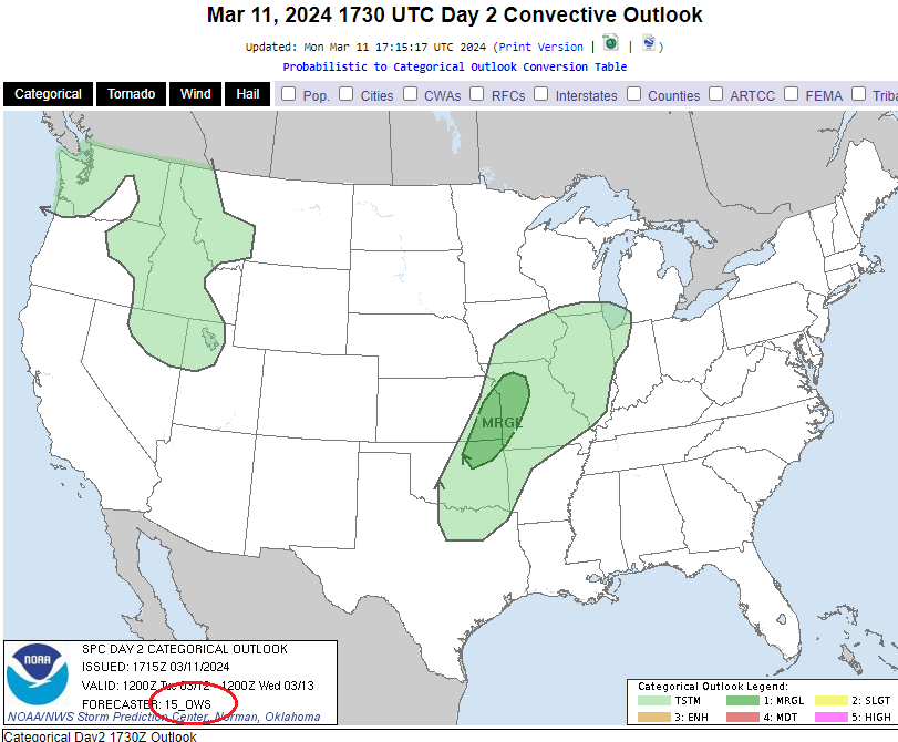
Hmmm. 15 ows? Interesting.
-
1
-
-
2 hours ago, Chinook said:
clouds cleared off just for me, in March, with east wind. what is this madness?

-
1
-
2
-
-
Looks like a good chance at a 1" soaker tomorrow night and Friday. We've been very dry after the mid Jan snowstorms so the moisture will be appreciated.
-
Hmmm, after seeing your pics I'm gonna change my name to lotterywinner
-
7
-
-
Finished with 0.58"
-
Most of this afternoon/evening's activity has skirted this immediate area, but a nice cell just hit with a brief torrential downpour and some sleet sized hail. Picked up a quick 1/4" of rain.
-
Over 20 severe hail reports so far in IA/IL/MO/WI. Looks like a slight risk definitely would've been warranted.
No severe watch either.

EDIT: Now over 30 reports of severe hail.
-
31 minutes ago, Chicago Storm said:
Some of these tornado warnings today have been eek bad.
Yeah I lol'd. Not sure what that was all about. Did see some pretty nice supercell structures, including the eastern QC tor warned hailer a short while ago.
-
Another new record high today at MLI at 77. Hit 76 here.

March 2024 General Discussion
in Lakes/Ohio Valley
Posted
Had a little burst of graupel a short while ago. Top 2 snow event of March so far.