

cyclone77
-
Posts
18,220 -
Joined
-
Last visited
Content Type
Profiles
Blogs
Forums
American Weather
Media Demo
Store
Gallery
Posts posted by cyclone77
-
-
DVN dropping the ball not reporting final results.
-
28 minutes ago, SchaumburgStormer said:
3” here, basically stacking more “stays for a day” march snow than I got in DJF
Kind of like garbage time points in the 4th quarter to the losing team in the NFL lol.
-
 2
2
-
-
0.5" here. No report from MLI or DVN for some reason.
-
Rain mixing with wet snow here now.
Picked up 0.79" of rain today.
-
Hailer #2 of the day. Fun little system.
-
1
-
-
The Euro definitely gets an F- for it's handling of the placement of the warm front today. We were supposed to make 70, but will likely stay in the 40s with a stiff northeast wind. This must be what it feels like to live along LM in May lol.
-
 1
1
-
 1
1
-
 2
2
-
-
We're probably gonna have to start paying TX property taxes if we keep getting more of their dirt. Have a dirty looking sky overhead with a muddy rain shower at the moment.
Nice arc of storms starting to evolve out over southeastern IA, and down into MO.
-
2
-
1
-
-
Nice hailer and a quick 0.45" from noisy elevated cell just now.
Looks like the warm front will stall near or just south of here now, so 70s are out. 1-3" of snow tonight.
-
1
-
-
50 minutes ago, Chicago Storm said:
hot-take: the wintry side on wednesday night/thursday morning will be more interesting around here than the severe side on wednesday afternoon.
My prediction for new day 1
-
1
-
4
-
-
7 hours ago, michsnowfreak said:
Ive never really dug into MLI data before, but now my curiosity is there, so ill play around later with some of their data and let you know if i find anything interesting. I always cringe when people discuss futility at northern locations in January...now, however, is a very legit time to discuss all-time snow futility for MLI.
The latest guidance has bumped the best secondary deform a bit east/southeast, so hoping to escape with no more than an inch.
Should be an entertaining day. 70s with a chance for severe, including a non-zero tornado risk. Then several hours later it will be snowing and sticking.
-
4
-
-
Some models show the tiniest deformation zone known to man streaking 2-3" of snow through this area tomorrow night, effectively ending the futility chase. How sad would that be? Either way will easily be the worst winter possible in anyone's lifetime, but it would have been nice to have the futility record to show for it lol.
-
3
-
1
-
1
-
 1
1
-
-
47 minutes ago, michsnowfreak said:
Is this for MLI or DVN?
MLI. DVN has only been around for 30 years or so, so doesn't have the historical records like MLI, which has been around since 1880 or something.
-
1
-
-
Hi-res popping a beautiful string of pearls from the surface low southeastward in a nice arc. If moisture can pool enough in front of that triple point a few tors would definitely be possible.
-
1
-
1
-
-
9 hours ago, Powerball said:
I don't know about you, but it would piss me off to have a futility record nickel'd and dime'd away in March...
Haha yeah, it's not surprising. All winter when it was cold most of the time we couldn't buy a flake, and now every system comes out wants to snow on us lol.
Luckily still a 2.4" cushion to work with, so if we can get past this storm with 2" or less still have a good shot.
-
1
-
-
Looking like 70s to snow in about 6-7 hours Wednesday/Wednesday night. Perhaps another 1-2".
-
1
-
-
MLI with just 0.6" overnight (only 0.2" at DVN as well), so still 2.4" of buffer left to achieve seasonal futility.
Looks like we'll rebound to the 60s already tomorrow, and then back to back 70s for Tue/Wed. Gotta love March.
-
1
-
-
A bunch of angry robins cheepin' out back this morning, as the grass is covered with a pretty thick blanket of wet snow. Picked up 1.5" here. All of the paved areas are completely snow free.
Don't think I've ever seen it go from the 80s to accumulating snow here before in such a short amount of time.
-
1
-
1
-
-
After being in the 80s yesterday looks like we could get an inch of snow tonight lol
-
2
-
-
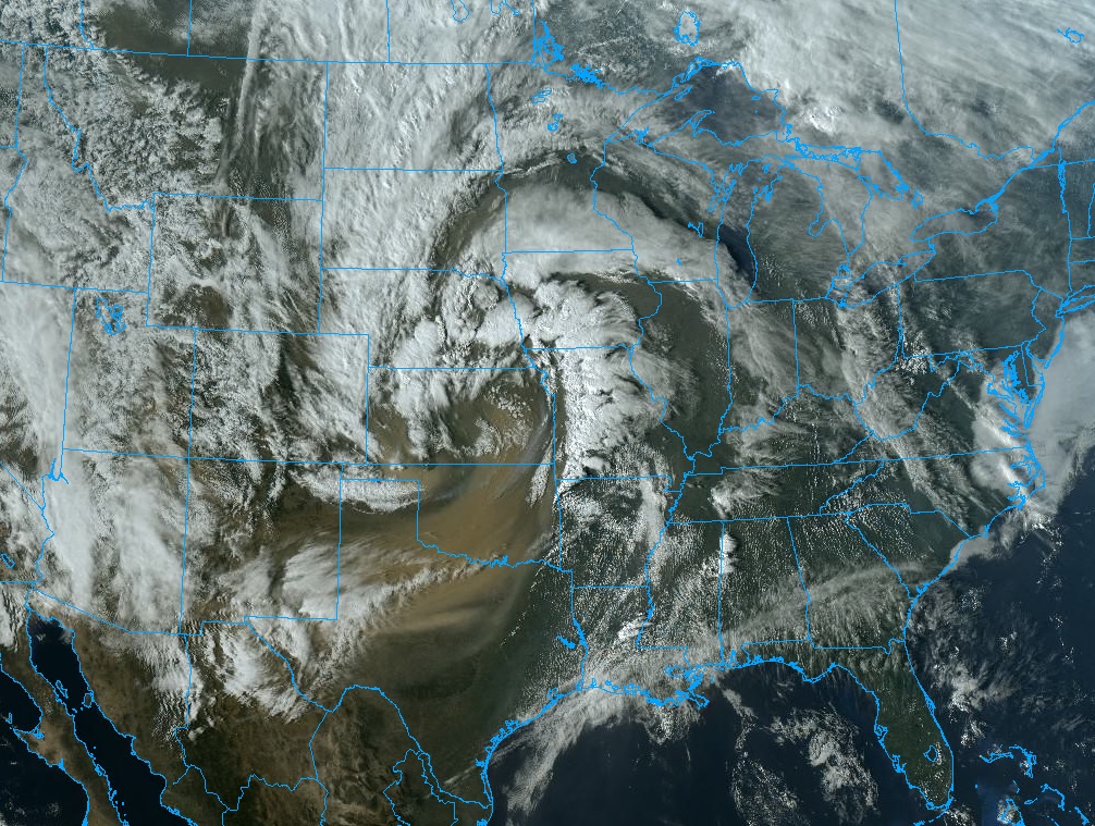
The back edge of the dust plume has passed through here. Much clearer now with full visibility.
-
Yeah pretty dusty out there with visibilities down under 3 miles in some locations.
Looks like LOT backed off the high wind warning.
-
50mph winds here a bit ago with the squall line. Luckily the high winds are becoming a little more sparse along the advancing squall line/wind shift.
-
71mph at Ottumwa
-
1
-
-
Absolutely beautiful. Wouldn't mind a large print of this puppy on the wall.

-
4
-
1
-
-
New record of 83 at MLI today, hit 81 here.
-
2
-

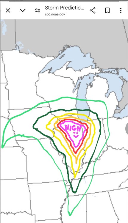
March 19 Severe Threat
in Lakes/Ohio Valley
Posted
Up to 8 confirmed tors by LOT now.