

cyclone77
-
Posts
17,664 -
Joined
-
Last visited
Content Type
Profiles
Blogs
Forums
American Weather
Media Demo
Store
Gallery
Posts posted by cyclone77
-
-
The parade of potent systems showing up in the mid-range by all the models is very impressive. It's like we have a nice rally going in baseball. Keep the line moving.
-
 5
5
-
-
4 minutes ago, Sciascia said:
Kind of a weird screw job from northeastern Iowa up into Wisconsin. Hopefully a scenario like that doesn't come to fruition lol.
-
1 minute ago, SchaumburgStormer said:
Yep. For having maps that had no snow through the entire run, this is a solid look.
Ready 2 roof-rake.
-
2
-
 4
4
-
-
18z GFS would probably produce drifts that would last till May in the La Crosse area. My god what a run.
-
Finished December with 2.7" of snow here, and 3.02" of precip. Not bad considering the overall pattern. DVN managed 5.2", and MLI received 2.9".
-
1
-
-
5 minutes ago, Stebo said:
Everyone knows Cromartie sucked
Some kind of sociopath. Gets off on trying to make people feel bad.
-
5
-
-
A few fast moving heavy snow showers deposited a quick 0.4" here early this morning.
-
1
-
-
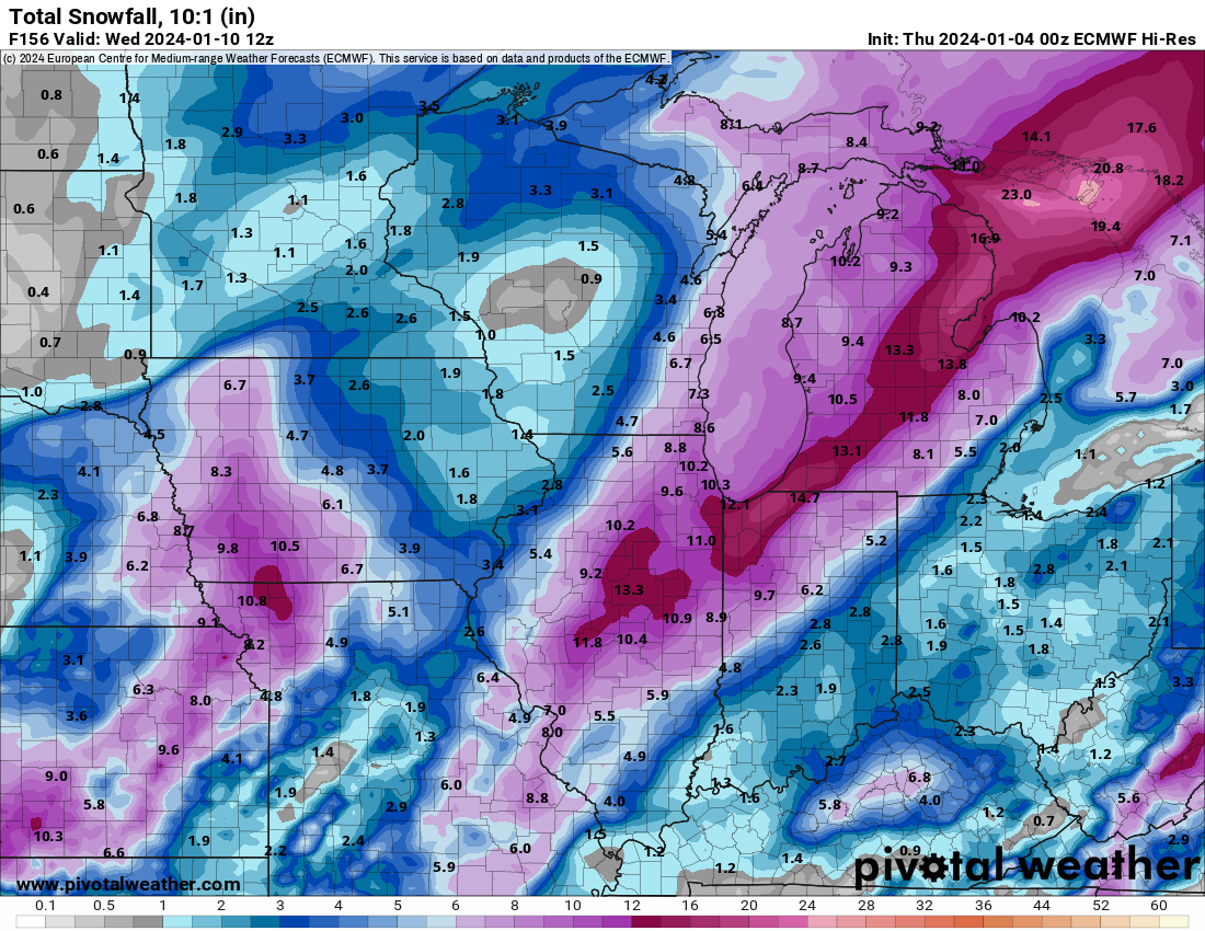
1 hour ago, CheeselandSkies said:
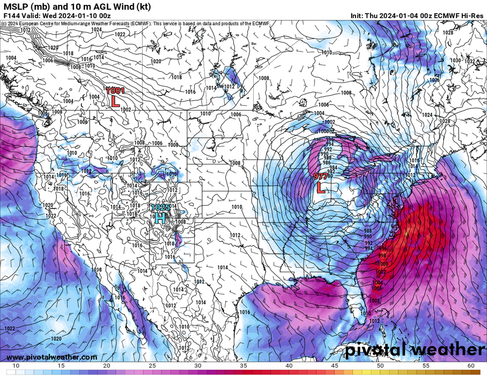
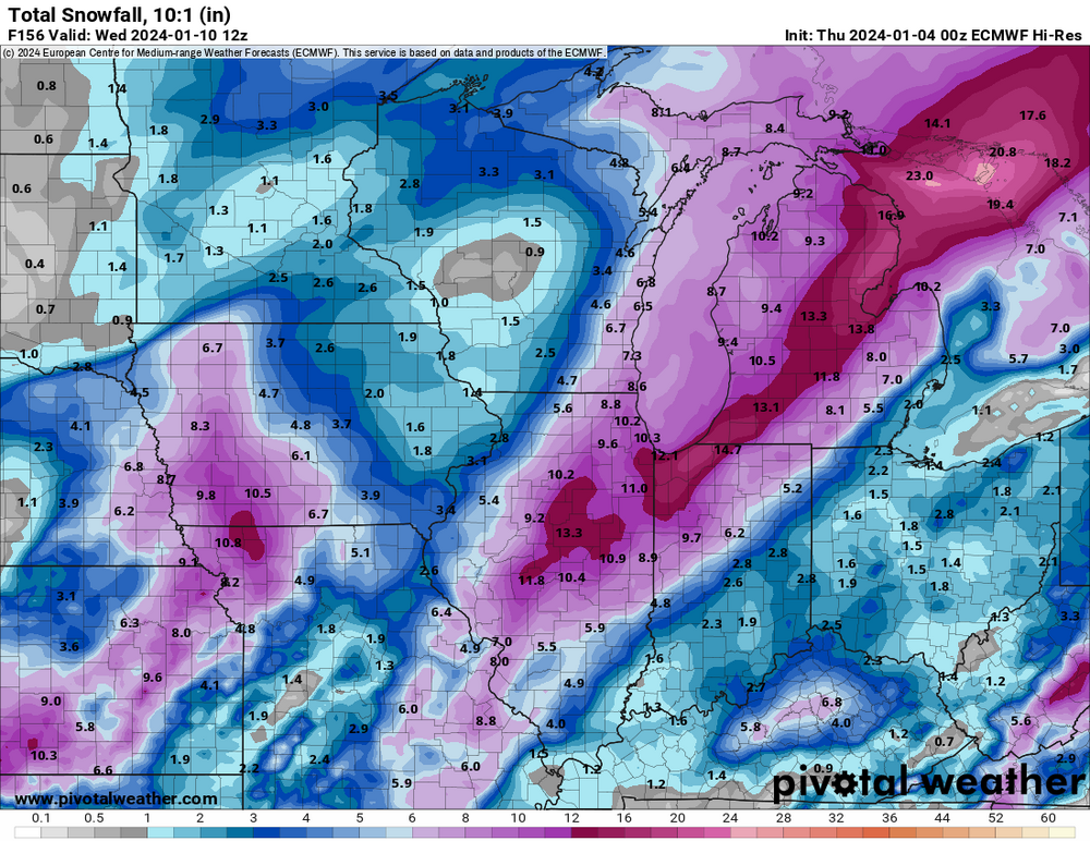
Anything in the teleconnections that would support the powerhouse being shown on the last several runs of the GFS around the 1/9-10 timeframe? Location, type and ceiling of impacts all way up in the air at this range of course, but a system of that caliber would certainly be very interesting to track regardless.
Long long way off but the consistency for something big showing up in that time frame off the op GFS is interesting.
End of the op Euro run, but has a nice look to it as well. Certainly seems like a good chance we'll finally have something to track with this.
-
4
-
 1
1
-
-
1 hour ago, CheeselandSkies said:
Was just thinking, wasn't that storm yet another 11th hour collapse of what had been consistently modeled high-end totals? All it was was f**king cold.
It looked like a major blizzard for places as far west as this area, and then it started bumping it eastward as guidance kept delaying the bomb.
Got <2" with that here as well, but the high winds/extreme cold were extremely impressive. Can't imagine how bad that would have been with 6"+ OTG.
-
2
-
-
Have picked up 0.8" here. If one were able to take official 6hr measurements we surely had more, as there's been several thaw backs of what has fallen throughout this 12hr+ event. If none of it had melted we likely would have exceeded 4 or 5 inches. Even though 80% of what fell melted it has still been a great event. Long-duration steady snowfall. Unlike what many of the models had advertised, we never transitioned over to rain.
-
4
-
-
Nice little vort coming down the pike for Sunday. Should produce nice snow showers much of Sunday for a good chunk of the sub. Won't amount to more than a DAB in places, but will be nice mood flakeage for New Years Eve.
-
4
-
-
A nice snowy day here. Mostly light/slowly falling snow but nice dendrites. Had a few bursts of smallish cottonballs. Warm ground and marginal temps kept the snow from accumulating more than a few tenths on grassy surfaces here. If it had been colder we would have accumulated 2"+. Now that it's nighttime it seems to be sticking better on the grass again.
-
5
-
-
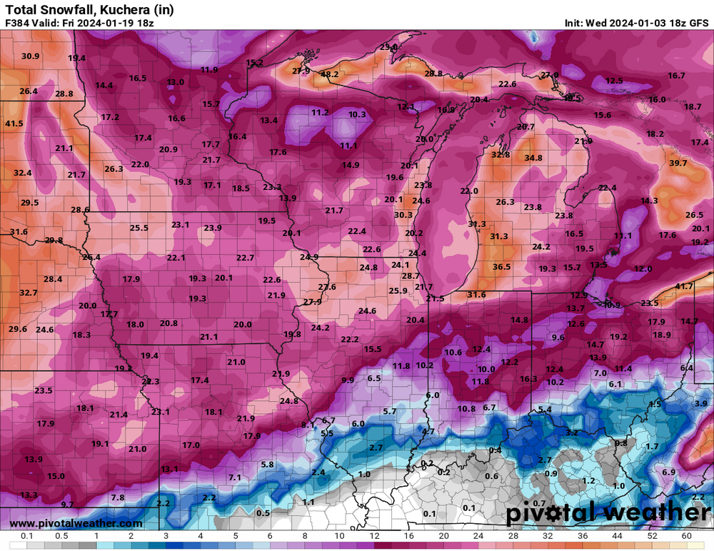
21 minutes ago, rainsucks said:
that storm near the end of the 18z GFS run would put both GHD blizzards to shame. I understand there’s next to zero chance of it verifying, but still fun to look at.
Lock it in!
-
1
-
 1
1
-
-
This will be a new one for me I think. Tomorrow it looks like wet snow changes to rain late in the day as the precipitation is moving southwest. Just when you thought you've seen it all lol.
May get an inch or two if certain models are correct, and perhaps up to a half inch of precip as well.
-
0.53 here today. Approaching 3" for Dec. Looks like we'll finish Dec with 1.5" snow.
-
3
-
-
Last Christmas the morning low was -1 here. This morning it was 50. What a difference between the two years.
Hopefully we'll have something interesting to track once we get 2-3 weeks out.
-
2
-
-
Feels like an April evening with dews in the 50s, sprinkles, jacketless humanoids roaming around outside.
Merry Christmas everyone!
-
1
-
-
Looks like about a half inch of rain tomorrow and then pretty quiet for the next 7-10 days.
-
1
-
 1
1
-
-
This is Rudolph weather with all this dense fog.
What a difference a year makes. Last year on this date we got down to -10 with -40 degree wind chills. This morning the low was 43 lol.
-
1
-
-
Today's 0.41" brings us up to 2.28" for the month. Not bad considering the fairly boring month overall.
-
29 minutes ago, andyhb said:
How has that guy not been banned yet...
He's like a dog that keeps yipping at you, and chases you around and won't ever shut up, making the same noise over and over and over.
-
2
-
1
-
5
-
-
Looking forward to some thunder xmas day.
-
1
-
-
4 hours ago, hardypalmguy said:
Nah I’m just not in denial that we are transitioning to winters more typical of England.

We get it buddy.
-
3
-
1
-
1
-
-
Other than rain looks like a snooze fest into early January.
-
2
-


Winter 2023/24 Medium/Long Range Discussion
in Lakes/Ohio Valley
Posted
We're all gonna have backyards like Bo's by the end of January.