LVblizzard
-
Posts
4,968 -
Joined
-
Last visited
Content Type
Profiles
Blogs
Forums
American Weather
Media Demo
Store
Gallery
Everything posted by LVblizzard
-
E PA/NJ/DE Winter 2023-2024 OBS/Discussion
LVblizzard replied to The Iceman's topic in Philadelphia Region
12z hi-res models are really bullish on Monday morning snow, especially west of I-95. If we can get that trough to dig just a little more we could be looking at some decent accumulations closer to the cities.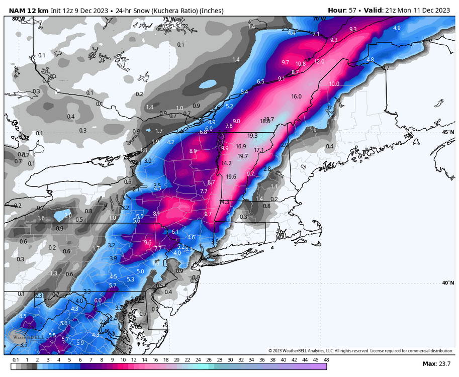
-
E PA/NJ/DE Fall 2023 OBS/Discussion Thread
LVblizzard replied to Rtd208's topic in Philadelphia Region
The first region-wide snowfall will happen sometime between December 1st and 6th. Why? I’ll be in London that week and it would be my luck to miss the first snow of the season. -
E PA/NJ/DE Fall 2023 OBS/Discussion Thread
LVblizzard replied to Rtd208's topic in Philadelphia Region
Medium and long range models are picking up right where we left off last winter with a warmer than normal pattern for much of November. There are some hints of pattern change after Thanksgiving but for now, we don’t even have any possible first flakes to get excited about. -
E PA/NJ/DE Fall 2023 OBS/Discussion Thread
LVblizzard replied to Rtd208's topic in Philadelphia Region
November is freaking boring. No hurricanes to track, no chances of thunderstorms, and snow is still weeks away. Looking at the long range GFS doesn’t even give us any fantasy storms. It’s just a brutal month for weenies. -
E PA/NJ/DE Fall 2023 OBS/Discussion Thread
LVblizzard replied to Rtd208's topic in Philadelphia Region
That was a good 2 hours of continuous thunder and lightning here. Enjoyed every little bit of it. -
E PA/NJ/DE Fall 2023 OBS/Discussion Thread
LVblizzard replied to Rtd208's topic in Philadelphia Region
Getting treated to a fantastic light show just west of Allentown. Haven’t seen nighttime lightning this good in a long time. -
Decent little storm passing through Allentown right now. No lightning but very heavy rain and some gusty winds.
-
Nothing crazy in the western suburbs of Allentown but we just had continuous thunder and lightning for an hour and a half. Still going too…looks like it’ll move out soon though. It’s been awhile since we had a nice nighttime storm like this.
-
This line is no joke. Ended my chase near Shrewsbury and I’m just letting it pass over me. Wind is gusting to 50-60 mph easily and lightning is nonstop.
-
Sun is out in Allentown. Not staying here today, though - going to head to southern PA/MD to chase there.
-
He thinks PA has the best tornado potential, but he posted that he’ll be chasing VA.
-
Upgrade to moderate risk (45% hatched wind!!!) southwest of Lancaster. Enhanced covers the whole area besides for the shore. I’m thinking the best storms stay south of the turnpike.
-
Tomorrow could go moderate towards the York-DC corridor. Would be the first moderate risk in PA in over 5 years (5/15/18).
-
First PA chase of the year for me tomorrow. I’m thinking York is a good starting point.
-
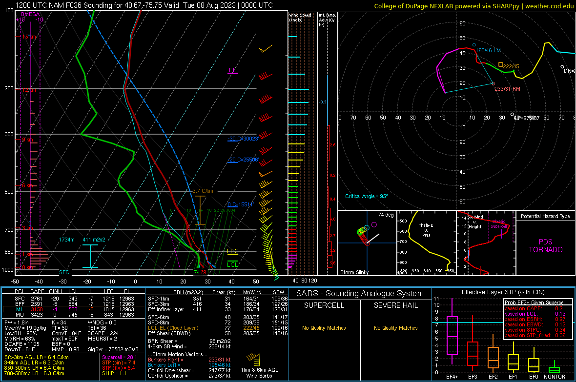
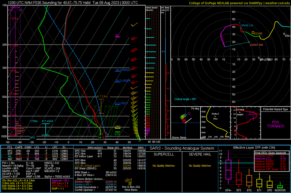
12z NAM has a PDS Tornado sounding for northern Lehigh County tomorrow. If a storm can tap into this…
-
Keeping a close eye on Monday's severe wx threat for the I-81 and I-78 areas. Some models are extremely bullish on a tornado threat. I will be out chasing if some good supercells get going.
-
Was at Wawa when the storms hit Allentown and the lightning was crazy there. At least 5 strikes within 1/2 mile and about a dozen within a mile or two. Haven’t seen a barrage of close CGs like that in a LONG time.
-
E PA/NJ/DE Spring 2023 OBS Thread
LVblizzard replied to Hurricane Agnes's topic in Philadelphia Region
Hell of a storm ongoing in Allentown. Lots of thunder and lightning, gusty winds, and even some small hail. -
E PA/NJ/DE Spring 2023 OBS Thread
LVblizzard replied to Hurricane Agnes's topic in Philadelphia Region
We got a light dusting on the grass which will probably be gone when I wake up tomorrow. Steady light snow continues here. -
E PA/NJ/DE Spring 2023 OBS Thread
LVblizzard replied to Hurricane Agnes's topic in Philadelphia Region
Yeah just flurries near Allentown. No accumulation of any sort anywhere. -
E PA/NJ/DE Spring 2023 OBS Thread
LVblizzard replied to Hurricane Agnes's topic in Philadelphia Region
This is one of those storms where downsloping off the Poconos creates a screw zone in the Lehigh Valley. Even the most optimistic runs have shown totals decreasing by a good margin from Carbon/Monroe to Lehigh/Northampton counties. -
E PA/NJ/DE Spring 2023 OBS Thread
LVblizzard replied to Hurricane Agnes's topic in Philadelphia Region
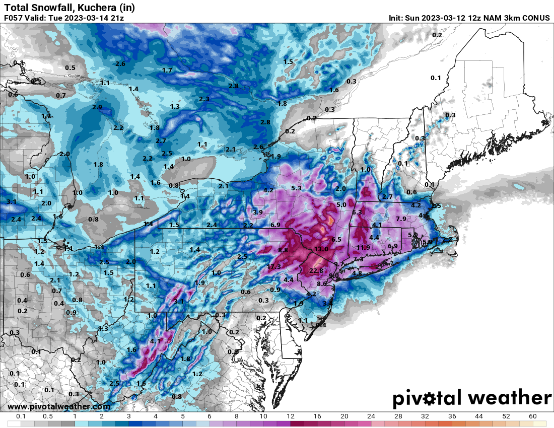
12z 3km NAM gets plowable snow all the way to Philly and south Jersey.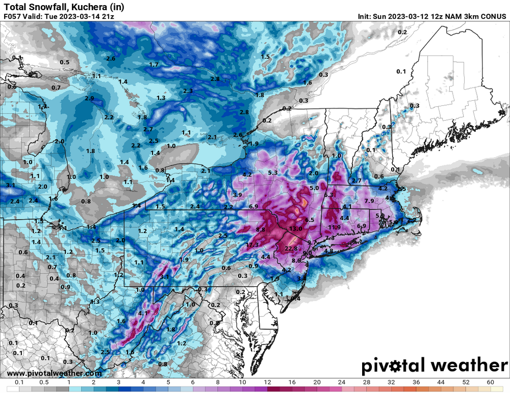
-
E PA/NJ/DE Spring 2023 OBS Thread
LVblizzard replied to Hurricane Agnes's topic in Philadelphia Region
GFS came southwest a little. Poconos get in on the good stuff while the Lehigh Valley sees plowable snow. Gonna be pretty close around here. -
E PA/NJ/DE Spring 2023 OBS Thread
LVblizzard replied to Hurricane Agnes's topic in Philadelphia Region
0z NAM says hello Lehigh Valley. Almost a foot of snow and still coming down hard at the end of the run. -
E PA/NJ/DE Spring 2023 OBS Thread
LVblizzard replied to Hurricane Agnes's topic in Philadelphia Region
The Euro has a bias of digging the northern stream too much, and as a result, it likes to show east coast bombs when other models have fish storms. Remember Juno? Probably the best example. Euro stubbornly showed 1-2 feet for the Philly area and held onto that solution till the bitter end. Actual amounts weren’t even close to that.