nwohweather
-
Posts
3,818 -
Joined
-
Last visited
Content Type
Profiles
Blogs
Forums
American Weather
Media Demo
Store
Gallery
Everything posted by nwohweather
-
Got the fireplace rocking today
-
Man this thread is woke. I for one am disgusted that the 1918 epidemic is referred to as the “Spanish Flu”. What a disgusting comment to those in Spain, how will they get by with such an offense
-
Definitely a major tornado out over the ocean at the moment...
-
Agreed but it costs $10 Million for a new one, and $500K a year to maintain. Very expensive technology for sure
-
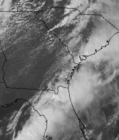
Right haha a quick step outside and you can visually see the LLJ absolutely screaming here
-
Charlotte cell moving into better instability and SRH as it goes east. To be honest it may drop in the city as I'm getting 80 mph winds already per RadarScope in the couplet
-
Nice updraft on the cell just west of Charlotte. If that thing tightens up could see a potential tornado in a heavily populated area
-
Nice little CU field back in GA here, sun is now out here as well
-
Terrible take in my opinion. Massive clearing is unfolding across GA/SC/NC with CAPE surging. We have 60-70 knots of bulk shear, SRH at 200-400 to boot. It would not shock me at all if the atmosphere recovers fully to get 1-2 long track tornadoes this evening
-
Gonna be interesting here folks. So much shear and helicity in the air, once we get this crapvection out of here that line is for sure going to spark of some storms all across SC/NC
-
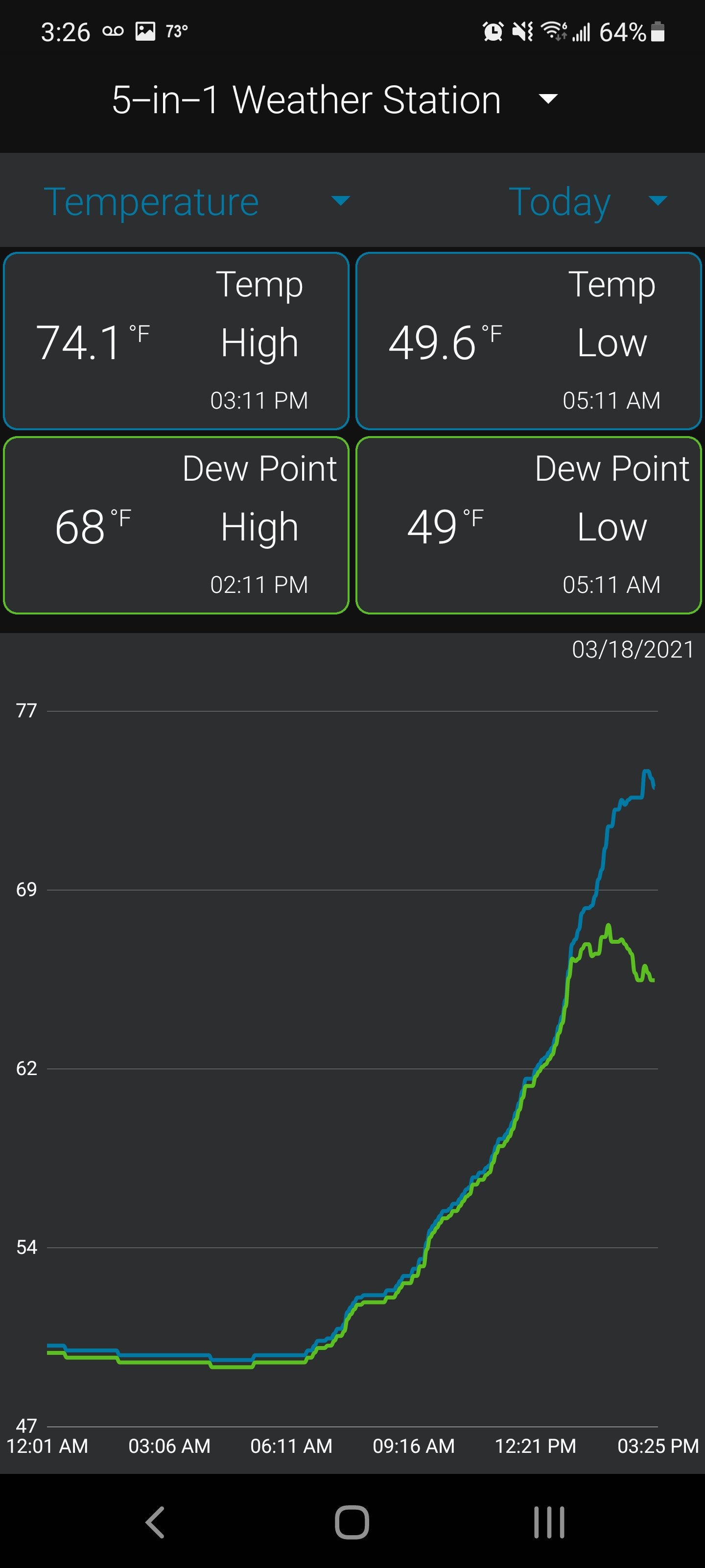
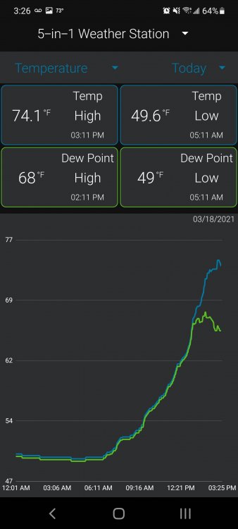
I’m overly bullish on today. Maybe I’ll get egg on my face but around 1-3 today it’s showing solid instability and helicity levels of 200-400 on top of the storms that spark up. 67° in Charleston at the moment
-
This wasn’t a bust. Not legendary so probably didn’t deserve a high risk, but absolutely lived up to a Moderate risk type event. It’s like forecasting 12” of snow and getting 8”. Sure the foot would’ve been cool but it’s still a lot of snow. I will continue beating the drum that I think tomorrow could wind up being worse. I noticed backing in the hodographs and a possibility of left movers tomorrow definitely increasing the large hail threat. Truthfully it’ll be a perfect day to camp out around Orangeburg and hop on 95 or 26 to chase. I’d be shocked honestly if there is not a violent tornado in SC tomorrow
-
The bust talk is a bit extreme, although I’m shocked Mississippi didn’t get a little more as the main show today has definitely been Alabama. Atmosphere is too worked over at the moment across the Mid South for this to really take off tonight in my opinion. Still it’s been one hell of an afternoon. And truthfully I think tomorrow in the Carolina’s offers a potentially bigger threat than today to be honest
-
This could be big dog of the day. Cell has little around it compared to other ones
-
Man I was just in Birmingham/Fairfield for a business trip. That tornado is going to go through some solidly populated areas
-
Tomorrow looks very interesting, especially if these storms today put a nice boundary down in the morning. Wedge has lifted in Charleston, sunny and 70 now. Looks like a solid two day outbreak here folks
-
I feel like I'm watching ESPN debating MJ vs Lebron for the 1,000,000th time seeing all the comparisons to April 27 on here. That being said, surface based CAPE across the region at the moment is insane for 11:30 AM. This atmosphere is so ripe, looks like a classic multi-round tornado event today.
-
I'd like to see a stronger low for sure to be in all in but with the ingredients in place, you've gotta go High for today. The LCL is basically on the ground, a strengthening LLJ throughout the day, as much as 3000 j/kg of CAPE, tons of moisture yet great lapse rates, extremely high SRH and ample shear. It's hard to think this evening that everything won't be spinning in the mid South
-
Comparisons to the infamous Carolina Outbreak are interesting for sure. Comparing anything to April 27th is a bit of a reach because the LLJ was absurd during the midday hours leading to some of the largest helicity numbers I've ever seen before, heck it was visually obvious with condensation still spinning off the funnel on many of the tornadoes. Also this low looks to deepen to 995-997 MB while that day had a 980 MB monster low which is why you saw not only great supercell development, but LP supercells compared to what is usually seen in the South. One thing to keep in mind is that tomorrow's outbreak could transform into multiple lines and put down a nice boundary for a Carolina event on Thursday.
-
Orangeburg would not be a bad place at all to sit out and watch this thing.
-
I think one thing this thread doesn't touch on enough is the regionality of the way we think about health in this country. I touched on this last year after my move, but it was shocking going from an Ann Arbor office to Charleston the difference in health measures. Almost all of my coworkers in Michigan were in some sort of fitness regimen (crossfit, pilates, long distance running, biking, etc.), salad bar with tons of options & wipes at the desk to help cut down on germs during flu season. I move here and absolutely no one is in any of those things, they eat fried chicken & BBQ regularly, and almost everyone dips. They're professional and college educated, but it's obvious health is not a priority except among young people who want to keep their beach body. It's hard to pass those kinds of public safety measures and expect widespread vaccine use when health just isn't the priority you see in other areas of the country.
-
Next two days have all the makings of a significant outbreak. Serious speed shear, great lapse rates, low LCL and solid instability in this moist air mass is going to help storms have enough spin not to get messy convectively in my opinion. Wouldn’t be shocked to see a few long trackers through MS/AL. The QLCS threat is interesting tomorrow night as well with the jet strengthening in the overnight hours to offset the loss of heating. Will probably see some off the charts EHI’s tomorrow night. Thursday seems complicated with this dang wedge front just lingering, could limit the northern extent of the outbreak a bit east of the mountains. Regardless, Thursday has the ability to be potent, especially into SC/GA. May go out and chase that day but also have a new truck so no hail haha. I want to say kudos to the SPC for going Moderate here and maybe High. Whenever there is a solid threat of long track tornadoes you have to make that call. Atmospheric profiles are far too good for a couple wedges and that’s going to be the real danger
-
Highly highly recommend Xyzal. I switched to it last year and it has been a lifesaver
-

Post your 2020-2021 Snowfall totals here
nwohweather replied to Avdave's topic in Southeastern States
0" -
Right? Apparently it’s where Sweet Tea was invented too