

USCAPEWEATHERAF
-
Posts
8,736 -
Joined
-
Last visited
Content Type
Profiles
Blogs
Forums
American Weather
Media Demo
Store
Gallery
Everything posted by USCAPEWEATHERAF
-

Perhaps a Coastal Storm on March 2nd for SNE????
USCAPEWEATHERAF replied to USCAPEWEATHERAF's topic in New England
I am sorry, I was thinking about my area. But everyone is right, the storm tracked further southeast this run. I will tone my enthusiasm down. Jerry you of all people should know the excitement that comes with storms. Gosh. I wonder sometimes. -
Perhaps a Coastal Storm on March 2nd for SNE????
USCAPEWEATHERAF replied to USCAPEWEATHERAF's topic in New England
Ok I see the difference in the runs from 6z to 12z. Its a slight difference, but QPF is not as intense in a 3 hour period, but it is more moderate and more widespread at 12z. -
Perhaps a Coastal Storm on March 2nd for SNE????
USCAPEWEATHERAF replied to USCAPEWEATHERAF's topic in New England
This is a very powerful and energetic storm developing and heading our way. Does anyone see the storms in Florida Panhandle? Not only does it take heat for storms to develop, it takes energy in the mid to upper levels of the atmosphere. Shortwaves provide that source of energy to produce updrafts and CAPE. -
Perhaps a Coastal Storm on March 2nd for SNE????
USCAPEWEATHERAF replied to USCAPEWEATHERAF's topic in New England
12z GFS closes off at 850mb -
Perhaps a Coastal Storm on March 2nd for SNE????
USCAPEWEATHERAF replied to USCAPEWEATHERAF's topic in New England
GFS is the same, I don't see any southeast movement everyone says they saw. -
Perhaps a Coastal Storm on March 2nd for SNE????
USCAPEWEATHERAF replied to USCAPEWEATHERAF's topic in New England
Come on Ray, the water temps have cooled off significantly to my northeast and north, that is where the wind is coming from with this storm. -
Perhaps a Coastal Storm on March 2nd for SNE????
USCAPEWEATHERAF replied to USCAPEWEATHERAF's topic in New England
It doesn';t make sense the warmth in the lower levels would come that close to the Cape, we have northeasterly to northerly winds as the storm tracks southeast of ACK and the benchmark. -
Perhaps a Coastal Storm on March 2nd for SNE????
USCAPEWEATHERAF replied to USCAPEWEATHERAF's topic in New England
The warmth in the low-levels comes from where? Northeasterly winds don't scream marine influence this time of the year. Storm track is far enough southeast of ACK the wind direction is northeast to north. -
Perhaps a Coastal Storm on March 2nd for SNE????
USCAPEWEATHERAF replied to USCAPEWEATHERAF's topic in New England
Then we shouldn't use any model correct? -
Perhaps a Coastal Storm on March 2nd for SNE????
USCAPEWEATHERAF replied to USCAPEWEATHERAF's topic in New England
The amount of precipitation didn't change, there is barely any mixing on Cape Cod where the QPF max is located. We could see 12:1 ratios as the comma head hits the area along with thundersnow potential. -
Perhaps a Coastal Storm on March 2nd for SNE????
USCAPEWEATHERAF replied to USCAPEWEATHERAF's topic in New England
I am not paying attention to this suite, the satellite imagery of the storm shows a strong system, upper support is strong and there is a strong GULF connection with no Atlantic source of moisture yet involved. This will be a big precipitation and convection maker, the surface low will intensify after hitting the ocean, and then ignites as it hits the Gulf Stream. -
Perhaps a Coastal Storm on March 2nd for SNE????
USCAPEWEATHERAF replied to USCAPEWEATHERAF's topic in New England
RGEM is all snow for Cape Cod even ACK. Provincetown seems to be the place to be in SNE this storm. 12-20" -
Perhaps a Coastal Storm on March 2nd for SNE????
USCAPEWEATHERAF replied to USCAPEWEATHERAF's topic in New England
ICON continues to show the region that gets the jackpot, SE MA. -
Perhaps a Coastal Storm on March 2nd for SNE????
USCAPEWEATHERAF replied to USCAPEWEATHERAF's topic in New England
Water vapor imagery is showing the surface low moving over NE GA now intensifying with the shape of the baroclinic leaf improving. The mid-level support system is phasing in with the GOM disturbance. -
Perhaps a Coastal Storm on March 2nd for SNE????
USCAPEWEATHERAF replied to USCAPEWEATHERAF's topic in New England
13z HRRR is actually not as "Meh" as you might think. Shows a further west precip shield as it heads northeastward. -
Perhaps a Coastal Storm on March 2nd for SNE????
USCAPEWEATHERAF replied to USCAPEWEATHERAF's topic in New England
Will what I believe argues against the premise of a weaker shortwave and low, is that the precipitation shield is beginning to show rotation as it moves northeastward and the amount of energy in the GULF states with lightning everywhere. Including the energy needed to produce a squall line. -
Perhaps a Coastal Storm on March 2nd for SNE????
USCAPEWEATHERAF replied to USCAPEWEATHERAF's topic in New England
Will, I think the models are mishandling the phase of the Great Lakes shortwave because the NAM, for instance, is too far east with the shortwave in the southern stream, with this phase between the MO disturbance and the GULF disturbance, this system will grow in size and allow the phased shortwave to slow down and grow in size and intensity. -
Perhaps a Coastal Storm on March 2nd for SNE????
USCAPEWEATHERAF replied to USCAPEWEATHERAF's topic in New England
Lol, my drawing needs a little work, water vapor shows a much better-developed system -
Perhaps a Coastal Storm on March 2nd for SNE????
USCAPEWEATHERAF replied to USCAPEWEATHERAF's topic in New England
The reason it is unreasonable is the vorticity is developed through the convection the model develops offshore. The vorticity looks to develop due to the convection, not due to the upper level energy within the shortwave. Water vapor imagery is a great tool to use in this case. The MO shortwave is phasing in with the Gulf shortwave, you can see this taking place as the shortwave begins to pivot in place. I will show you an image of what I mean. Image below shows the developing storm system, with the strong baroclinic leaf in the southeast, the dry slot developing to the west of the low is where our disturbance has phased together with the top of the storm now taking shape.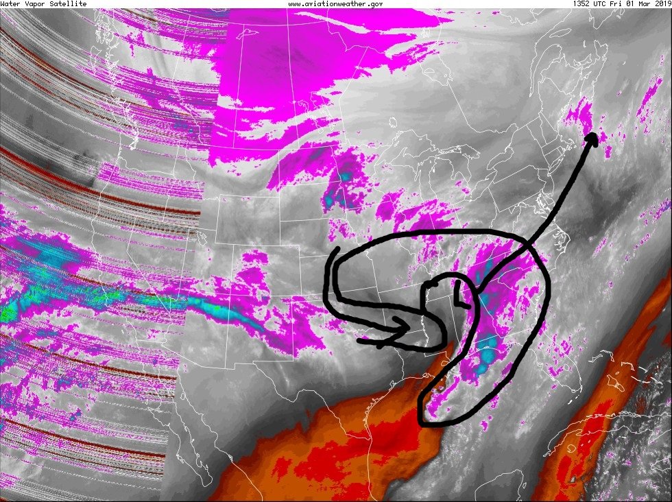
-
Perhaps a Coastal Storm on March 2nd for SNE????
USCAPEWEATHERAF replied to USCAPEWEATHERAF's topic in New England
Our GULF/MO low is finally phasing in together, look at the morphology of the water vapor imagery. Amazing work. -
Perhaps a Coastal Storm on March 2nd for SNE????
USCAPEWEATHERAF replied to USCAPEWEATHERAF's topic in New England
Not buying into the NAM yet. Until I see other guidance fold, I will not buy into it. -
Perhaps a Coastal Storm on March 2nd for SNE????
USCAPEWEATHERAF replied to USCAPEWEATHERAF's topic in New England
Do you read the title of the thread? -
Perhaps a Coastal Storm on March 2nd for SNE????
USCAPEWEATHERAF replied to USCAPEWEATHERAF's topic in New England
The important energy right now is the Northern US Plains vort max that curls around the Polar Vortex influenced Arctic Jet Stream. This disturbance can phase into the Gulf Shortwave, we can have a major nor'easter like the GFS shows. HIRES short range HRRR 12z run shows a powerful storm developing. -
Perhaps a Coastal Storm on March 2nd for SNE????
USCAPEWEATHERAF replied to USCAPEWEATHERAF's topic in New England
Jim Cantore mentioned he believes lightning is possible in SNE tomorrow. -
Perhaps a Coastal Storm on March 2nd for SNE????
USCAPEWEATHERAF replied to USCAPEWEATHERAF's topic in New England
I will never be suicidal over the weather, something as out of our control as that, it is not a good thing. I have been through my darkest days, I will not let myself get that far again. I don't joke around about something as serious as suicides.


