USCAPEWEATHERAF
-
Posts
8,736 -
Joined
-
Last visited
Content Type
Profiles
Blogs
Forums
American Weather
Media Demo
Store
Gallery
Everything posted by USCAPEWEATHERAF
-
 **Alert Level** (High), potential snowstorm impact in the next three days, high! Parts of the Denver region could see multiple feet of snow in the mountains and in the city region. Snowfall amounts of 10-30" is possible as the period ends 00z Wednesday, or Tuesday 8 pm EDT. Multiple model consensus shows a strong trough entering CA now and moving over the area by Monday afternoon into Tuesday. This will lead to leeward cyclogenesis to occur as the trough tilts more neutral. This will lead to an area of blossoming precipitation on the northwest side/cold side of the low pressure center. Impact will be expected in the high range. Heavy snow and strong winds could lead to blizzard conditions. Tuesday into Wednesday could see the heaviest snowfalls, over 12". This could lead to snow over Chicago, IL and become an intense storm that changes the pattern across the central and eastern CONUS. Updates to come in the next few days!SREFs show an all out huge snowstorm for Denver, CO
 -
The Climate Prediction Center is more than 50/50 confident, precisely 55-60 % chance that neutral ENSO pattern will persist until Spring 2020. We are becoming more confident on an equal opportunity winter for above normal snowfall from PVD to BOS to Portland ME. I will have further updates first week into the first ten days of November.
-
Multiple model consensus suggests that the current evolving pattern for the Equatorial Pacific Ocean basin wide is favoring neutral-ENSO pattern. CPC suggests there is a more than 50/50 chance of a neutral ENSO persisting until Spring months of 2020. This should favor a strong winter favoring above normal snowfall for eastern to central New England with a below average temperature climate. Long range models suggest the pattern evolving this weekend will lead to a prolonged cold air mass. More will become present as we head into the first week of November.
-
Hello southern New Englanders, this evening update is about the latest guidance showing a potential pattern change storm erupting in the 5-10 day range. This storm signals the erupt change to a colder and maybe perhaps more stable pattern towards Halloween and the change into the month of November. Deep cold is on tap for after the next week. Stay Tuned! Winter is still around the corner.
-
Models in the long range, are beginning to show a winter like pattern beginning late OCT, sometime after the 27th. In the next two weeks of OCT, warm air is settling in after our mid-week miller B storm center offshore of MVY sometime WED night. Cold air will dump into the central Northern CONUS north of 40 north latitude.
-
The next four days present an unique challenge for weather forecasters. Models present a blocked upper-level pattern which ensues at the surface as well. A large ridge in Atlantic Canada will keep the coastal low pressure blocked at the surface and rather stalls or meanders off the coast near the New England storm benchmark location or 40N:70W. Winds will increase after 12z tomorrow into 12z Friday, they should peak between 55-70mph winds at the coastline between 12z Thursday and 12z Friday. Heavy rainfall over 5" should be a common number when this storm exits Saturday night/Sunday morning. Be prepared for a raw few days from I-95 corridor eastward will be the main region impacted from eastern CT to Eastern ME.
-
Cold Season weather today!
USCAPEWEATHERAF posted a blog entry in Snowfall Updates and Forecasts 2019-2020 and beyond!
Today radar imagery shows Ocean Effect precipitation is developing and falling over the Outer Arm of Cape Cod this early afternoon. Radar shows flow is out of the north to northwest with rather cooler air mass moving over the low 60 degree ocean waters over the bay. Sprinkles and a few misty periods have developed. Radar image below shows this well.https://weather.cod.edu/satrad/?parms=local-Rhode_Island-comp_radar-24-1-100-1&checked=map&colorbar=undefined -
Top 5(ish) New England Weather events
USCAPEWEATHERAF replied to HoarfrostHubb's topic in New England
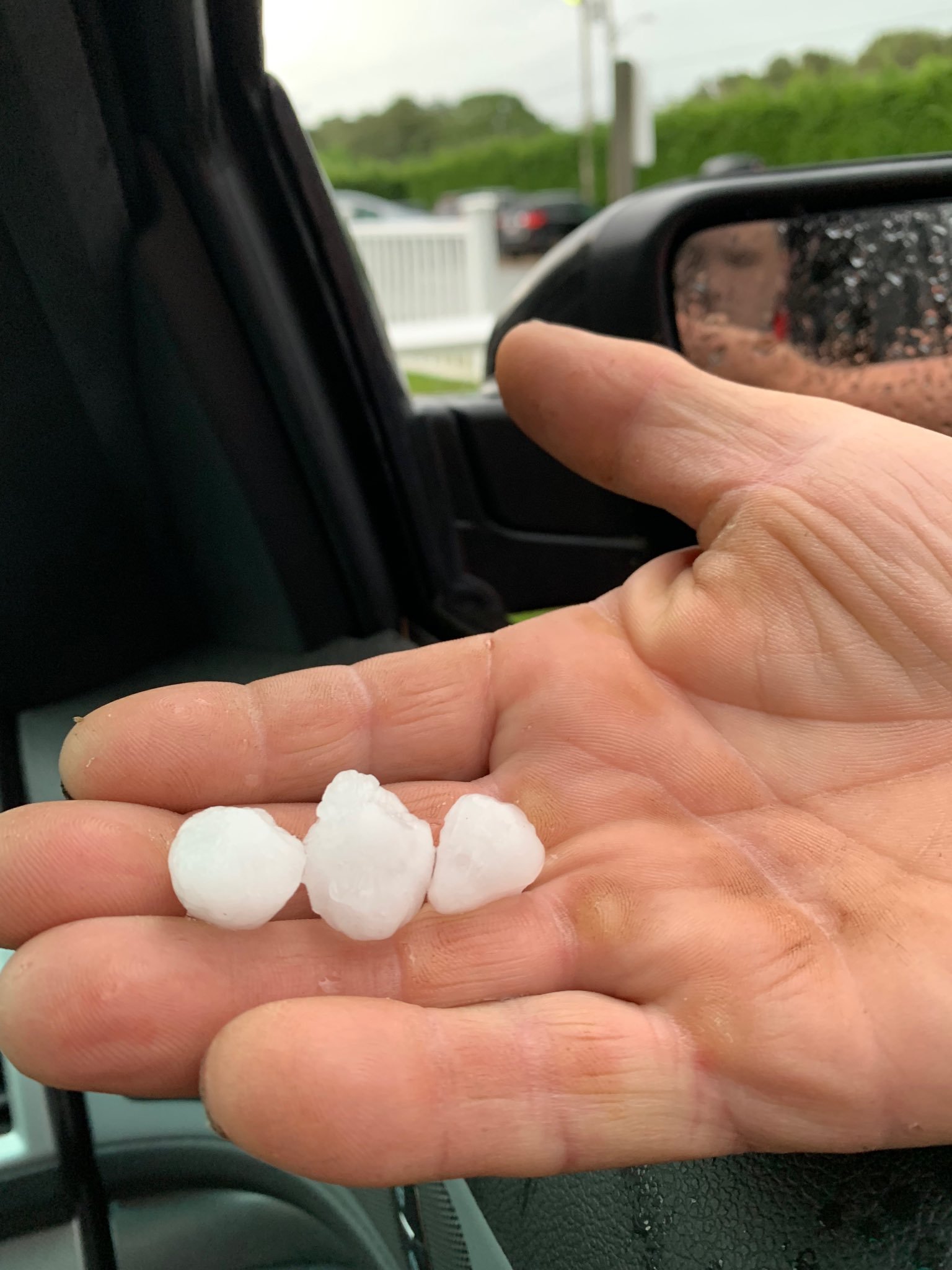
The July 23rd, 2019 tornado on Cape Cod that occurred in my town of Harwich, wasn't the only severe weather event this past summer, another hail event with stones about quarter sized occurred on June 22nd, 2019. That was cool.https://twitter.com/89Nich/status/1180108248122351616/photo/1
-
Upcoming weather for New England!
USCAPEWEATHERAF posted a blog entry in Once a legend always a legend
Latest guidance and weather data suggests the rain that was impacting the region this morning is out of the way now, but cloud cover should stay in control for most of the morning into the early afternoon, before some clearing occurs as a strong Canadian High builds in from the northwest. Tomorrow looks dry and cool, with highs in the lower to middle 50s and lows near 45F. Sunday looks similar with perhaps a stronger and warmer return flow as the high shifts to the east with a rather nice rebound temp wise into the upper 50s and lower 60s and lows again in the mid to upper 40s. Frost is possible the next few days across the interior of New England and the mountains of the area. Monday will feature a warmer day than the weekend as a front approaches from western NY. Temperatures will return into the mid to upper 60s maybe some locations nearing the lower to mid 70s perhaps for the last time until March, unless a period of Indian Summer reaches that mark again this winter season. Perhaps the next time we see temperatures in the mid 70s will be late April early May 2020. Monday will feature warm temps, but the return of high altitude cirrus clouds and then thickening clouds towards sunset and temps lowering no more than 60F in the overnight hours before the cold front passes through late Tuesday morning. Temperatures will peak in the morning and then fall dramatically throughout the day into the lower 40s into Wednesday morning. Wednesday through Friday appear to be the middle 50s for highs and lower to middle 40s for lows until the weekend features potential for another cold front that will bring rain showers and colder air for the weekend into the early week. Stay Tuned! We will likely see subtle changes in the coming days to the ten day forecast. - JWN Productions! -
Attached is the guidelines for the different threat levels I will put in place for each snow event in the future from end of November through the first week of April 2020. Snowfall amounts and impacts forecast technique.docx
-
The Weather Channel - Naming List of Storm Names
USCAPEWEATHERAF posted a blog entry in Once a legend always a legend
List of names (TWC) issued for the 2019-2020 winter season: Aubrey - Bessie - Caleb - Dorothy - Ezekiel - Finley - Gage - Henry - Isaiah - Jacob - Kade - Lamont - Mabel - Nash - Odell - Pearl - Quincy - Ruth - Sadie - Thatcher - Upton - Veronica - Wyatt - Xandra - Yates - Zachariah -
First Signs of Winter showing up!
USCAPEWEATHERAF posted a blog entry in Snowfall Updates and Forecasts 2019-2020 and beyond!
Today, I have been sifting through the data and the guidance as of the 00z runs 10/3 and they are showing me the signs towards winter are upon us. New England weather is rather volatile the further we get from the summer and we get deeper into the season of Fall and then winter. As the holidays approach we are reminded how lucky we have been to live life as long as we have, and to have people who care about us in this world. As the holidays approach we are reminded of this constantly. As winter approaches abruptly and the only way Nature knows how, we get warning signs that the weather machine is ready to change gears and this is what I am seeing on the guidance this morning. There is rather strong agreement that a clipper will develop a secondary low off the coast of Cape Cod and Nantucket (ACK) as we head into the weekend. This system will carry a cold air mass on the north side and then northwest side and bring a change of temperatures to the region from the backside winds. Before that happens, we will experience spotty rain, until you are north of Concord, NH where rain will become more steady and then changeover to snow as one heads into the mountains of northern NH/VT/ME and the mountains of this region in the weekend. Saturday will be rather raw and spot showers at times, and then Sunday will be quite beautiful and rather chilly compared to what the last few days have given us. Also, another sign of the change in seasons is the rather rapid build-up of cold deep arctic air masses into northern Canada and then into the central and southern Canadian Prairies. This will begin to dive into the northern third of the US, above 40N from MT to ME as we head into the mid-month period and then the end of the month and beyond. Rather active weather pattern will begin to impact the US as multiple troughs will swing through the northern tier, this is rather common in neutral ENSO patterns. I will have another update after the 12z EURO if something changes in the guidance. -
ENSO conditions update for the 2019-2020 Winter
USCAPEWEATHERAF posted a blog entry in Once a legend always a legend
Today's update is a short appeal in the overall envelope of winter solutions. Today's neutral ENSO conditions update supports an average to slightly above average snowfall for all of New England. Again we should have a much better handle towards the first several weeks of November on what the ENSO pattern should be like. Eastern and Western New England have equal opportunities for above average snowfall this winter, which is quite normal within strong neutral ENSO phases. -
ENSO conditions for this upcoming winter
USCAPEWEATHERAF posted a blog entry in Once a legend always a legend
Right now there is a greater than 55 percent chance of neutral ENSO conditions this winter. This should favor above normal snowfall across most of central New England, with a tendency towards slightly above average snowfall for eastern New England and less towards normal across the northern and western parts of New England. Storm tracks should be favored more eastward then last winter, more so from 35N:75W to around 41N:69.5W as an average storm track location. Coastal plain of New England could see slightly above average to potentially above average snow. I would say the Outer Cape from CHH to P-town could see around 30-45" of snow, parts of the Cape from CHH west to HYA could see 40-55" and parts of the Cape from HYA westward over 60" of snow. So these numbers support slightly above to above average snowfall this winter. -
2019 ENSO
USCAPEWEATHERAF replied to AfewUniversesBelowNormal's topic in Weather Forecasting and Discussion
What is this winter expecting? Does anyone know when a triple-phase storm is expected? -
2019 ENSO
USCAPEWEATHERAF replied to AfewUniversesBelowNormal's topic in Weather Forecasting and Discussion
Was the winter of 2014-2015 considered a warm neutral ENSO? -
Top 5(ish) New England Weather events
USCAPEWEATHERAF replied to HoarfrostHubb's topic in New England
For severe weather, June 2008 Hail storm, July 23rd, 2019 Tornado EF-1, 110mph winds. Winter events: combo of Winter 2004-2005, and 2014-2015, single event of FEB 8-9th 2013, microburst 2005 DEC 9th NOREASTER. Hurricane Season 2004, the discovery of Wunderground.com Dr. Masters' blog. -
2019 NFL Season and Playoff Outcome Predictions
USCAPEWEATHERAF posted a blog entry in Once a legend always a legend
Predictions made by James W Nichols I outlay the potential standings and records and playoff matchups and outcomes. Questions?? I would love to debate them. It is the attached file. The 2019 NFL Season Predictions.docx -
The eye is really clearing out, radar shows an intensifying eyewall. Visible satellite imagery shows hot towers in the NE Eyewall.
-
**Alert - Alert - Alert** (Hurricane Dorian update)
USCAPEWEATHERAF posted a blog entry in Once a legend always a legend
Yes, unfortunately, Dorian is now a hurricane. Models showing a potentially catastrophic hurricane heading towards the south-central east coast of Florida landfall in the next 4 to 5 days. Stay tuned as the models show an extremely dangerous hurricane making the approach to the Space Coast of Florida. -
While my dreams are in motion, my plan is in the flow of life. Today I am poor, tomorrow I am a billionaire.
-
Tornadoes possible for SNE today!
USCAPEWEATHERAF posted a blog entry in Once a legend always a legend
Major Severe Weather Outbreak is underway today over SNE as the first tornado warning has been issued for Middlesex County, MA. The rest of the region shows increasing potential for intense damaging winds over 70mph, large hail over 1.5" and a few tornadoes. Severe Thunderstorm Watch in effect until 10 pm tonight. -
Fireworks have begun for Tom Brady and his list of WR weapons on the outside. With Josh Gordon and Julian Edelman back yesterday at practice, today the Patriots get tremendous news that Demaryius Thomas has returned to practice after suffering from a horrible Achilles tear injury last season with the Texans. After signing a one-year deal with the Patriots, Thomas has returned to action and is officially taken off the PUP list. This adds another veteran weapon on the outside at a size of 6'3" 220lbs or heavier along with Gordon 6'3" too and N'Keal Harry who is the tallest at 6'4" and 230lbs. That gives them three large bodies, athletic WRs for Brady and the offense. Along with a deep backfield, the TE position is missing one true TE from being a formidable offense this season. Barring any further significant injuries, this team has the ceiling of a perfect season repeat. I believe it is a dumb part of anyone in the prediction business to predict a perfect NFL season, even if the Patriots did it just 12 years ago. It is possible, about a 12 percent chance. I am still on track to deliver my predictions officially by September 5th, they should be posted then, but I will work between 29th to the 4th on this process.
-
My novel is progressing, we hope it will be finished before November 1st, 2019. We could get it published as soon as Spring 2020. Fingers crossed! As for my NFL predictions release, that won't come until the first day of NFL games, which is two weeks from Thursday, September 5th. I will release my thoughts than, stay tuned! Another thing, Josh Gordon is dealing with something far greater than substance abuse issues. Most people who suffer drug or alcohol addiction are trying to mask the inner pain of an emotional loss. Something either traumatic happened to them in the maturation process growing up, before the age of 30, or the loss of a personal friend or family member in which anger was pushed to the side and not dealt with head-on can cause significant mental health risks, such as depression and illness. Our minds are so fragile, while also so strong, we still have no idea what over 80 % of the mind does for the human body. That is amazing. Josh Gordon I hope pulls through, not because of his tremendous talent that will help the Patriots, but because as a human being, we love success stories, underdogs, people who beat the odds of life and their circumstances to overcome the tragedy they face in life. I want him to have that story. A lot of people pull for someone trying to relinquish the demons he is fighting.