Trent
-
Posts
2,813 -
Joined
-
Last visited
Content Type
Profiles
Blogs
Forums
American Weather
Media Demo
Store
Gallery
Everything posted by Trent
-
Looks like CLE will end the season with 32.8" of snow. That's the least amount of snow at CLE since the 1957-58 season when the record lowest of 31.1" fell at the airport. The weather of recent has been pathetic. March was more springlike than April.
-
Finished with about 6" here. What a way to end winter.
-
I can't believe it actually happened! 5.6" has fallen so far and it's still coming down.
-
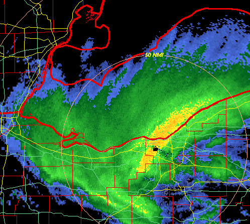
I believe it's 6" in 12 hours or 8" in 24 hours. It actually seems like a lot of areas could potentially meet warning criteria. Trends have favored areas more to the SW. I wouldn't be surprised to see a jackpot somewhere in southern Lorain County.
-
CLE least snowiest winter on record cancel. It's a shame the best snow will probably be while most are sleeping, but if you want a big snow this time of year, night is the time for that to happen. It's pretty much a lock that this will be the biggest storm of the season for the TOL-CLE corridor.
-
The NAM has a very nice 8" swath of snow across the most populated areas of Northern Ohio. It'll probably be nowcast time, but wow if this ends up being CLE's largest storm of the season AND the largest of the past few years. I'm a little concerned about being close to the lake, but a few mile drive inland should make all the difference between winter wonderland and slushy grass.
-
Just a dusting here, but even CLE had 2" over night. In fact they even had a 1 inch per hour observation on a METAR last night at 8pm.
-
And here we are in early April with a potential 6" snow storm at the end of the week. Won't be hard for this to be CLE's largest snowstorm of the season.
-
It will be interesting to see how much, if any, snow accumulates this week during the cold snap. Saturday night's thundersnow was probably the best thundersnow I've experienced. Lots of lightning in rapid succession. It helped that the snowfall occurred after sunset for accumulations. This time of year you need intense rates and nightfall to really get snow to stick. But minutes after it stopped, the snow started melting here from the ground up. The pavement was covered in snow during the squall, but 15 minutes later it had completely melted from paved surfaces, even with air temperatures falling into the 20s.
-
I'll gladly take an April 2007 style lake effect event, but if it's just going to be a nuisance coating I'll pass. As of now, for Cleveland proper, this is likely the second least snowiest season since 1870. CLE Hopkins will likely break their futility record, currently sitting at 25". I would guesstimate that lakeside/downtown is sitting at less than 20" on the year as a comparison to the pre-airport records. The second least snowiest winter downtown was 21.5" in 1931-32. It will be interesting if any LES materializes next weekend and if it will end up effecting downtown or the airport or the primary snow belts. The lake is getting quite warm so I wonder how much it will modify the cold air.
-
With the way March has progressed so far, I've forgotten climo says we should see another 6" yet this season. I bet CLE finishes with a few more inches this year. If not their first inch stands at January 10th, with last inch on March 3rd. Not even 2 months of real accumulating snow.
-
CLE was able to creep up to 25" for the season after this weekend. That's still 43.1" below the total seasonal average or 36.7% of normal. Biggest synoptic storm of the season was 3.3" and the best lake effect band was 3.8". Still lots of time for more accumulating snow, but with the forecast for the week ahead the odds of making a significant dent in the deficit are pretty low.
-
2.5" at CLE. Not bad for this winter. It snowed for almost 16 hours straight too. Too bad we can't seem to get heavy rates and long duration at the same time. This was another storm where the pavement stayed wet throughout the event. I think there may have been only 3 times this winter I actually had to move snow from the driveway.
-
I'll go on the record to say that futility will never happen again in Cleveland unless official records are moved to Burke Lakefront Airport. If you look at all the least snowy years they are all taken downtown lakeside. It's hard to say what CLE would have recorded during some of those years to compare to this year, but suffice it to say for records kept at CLE airport, this winter is by far their least snowiest in 75 years. Of course 6+ weeks remain where a storm could pop up and change all that, although the 365 day rolling year total still stands at about 23". I'm ready for spring, but I would enjoy a late season storm. I think it would be a funny end to this winter if an 8" storm popped up in April. I'd also gladly take an April 2007 repeat. With all the synoptic fails here the past few years, when that widespread 8"+ event does hit, people won't know what hit them.
-
A lot of the near west side's snowfall has been from a few small lake effect events. It's not surprising that Erie County is that low considering they probably missed a few of those. Just a trace here overnight. Not all that unexpected given this winter. At this point I'm hoping the upcoming event is a miss. Might as well see how awful this winter can get. No one is going to be happy with a couple inches of fluff snow in March.
-
Is Athens beating CLE for snow this winter? I wouldn't be surprised if it's close. Last fall I figured this winter would be less snowy than normal, just didn't think we'd be looking at one of the least snowiest winters in 100 years. I'd say the odds of CLE finishing with a sub 30" winter are pretty high at this point. A sub 25" winter is probably 50/50 now.
-
What a model fail. Hard to believe the Euro had a couple 12" hits here at such close range. Forecast high today is 42, wouldn't be surprised if spots make it into the 60s instead.
-
Euro now has an inch or two for NE Ohio with the upcoming storm. CLE sits at 21.6" of snow on the season. Last year only 1.4" fell at CLE after March 1st. That means CLE's running 365 day snowfall total is just 23". A sub 25" winter is certainly still in play. We are at the point in the season where frequent nickel and dime events are pretty much over. If CLE cracks 30" this year it'll be from a "big storm" or two. I can't envision six more 1-2" events happening now through April without a locked in cold pattern to hit 30".
-
The Euro has had some decent hits for us the past few runs. That would have led me to be more optimistic in prior seasons. I think a 3-6" hit looks reasonable right now, but still lots of room for this to bust either way.
-
No model consensus for a storm a few days away - sounds like March. Verbatim the Euro is a foot+ for all of NE Ohio up through Buffalo. I will gladly take this storm and move on from winter weather.
-
From the PNS last night, CLE had an inch and Euclid was the biggest loser at 0.5". With no snow in the forecast until the potential storm next week, CLE's 365 day snowfall tally will be at 22.8" and this season's at 21.6 inches. There's plenty of room for CLE to get a decent storm next month and still be the least snowiest season at the airport.
-
Amazing what a little elevation does! About an inch in Lakewood. Grass was barely coated downtown.
-
Snow finally starting to pick up, but the back side is fast approaching. Might end up with an inch.
-
Visibility is dropping but there's just not much sticking/falling from the sky. The radar (at least for the lakeshore) is extremely overdone. Even the latest METAR from CLE shows this with 1/4 mile visibility but only 0.01" liquid the past hour. I think we can file this event under bust. What a disaster winter this has been for snow.
-
Perhaps the folks at the higher elevations are doing better, but based on the radar you'd think it would be snowing a lot harder than it is. Still struggling to get accumulations here with maybe a few tenths down.