Trent
-
Posts
2,813 -
Joined
-
Last visited
Content Type
Profiles
Blogs
Forums
American Weather
Media Demo
Store
Gallery
Everything posted by Trent
-
As feared, strong northerly wind component is keeping the best snows inland from me. You can see the flare ups occurring south of the turnpike in Lorain and Cuyahoga County and then along the higher elevation east of 271. If a Huron band develops, someone will jackpot nicely.
-
The wind sure is whipping. Walking outside this morning there are a lot of areas with bare grass and then areas of 5-6" drifts. My entire yard has grass tips still showing with drifts near fences and south facing areas (where wind blew the snow off the roof).
-
The synoptic portion of this storm was certainly a dud IMBY. I have about 1.5" on the ground. Hopefully the lake effect can over perform later.
-
Based on the radar from Milwaukee, the lake effect/enhanced snow in Wisconsin seems to be doing well. Hopefully that bodes well for Northern Ohio tomorrow.
-
Ouch. NAM comes in even drier overnight through about noon tomorrow. It only shows a widespread 2-4" snowfall for the region, 2" far west and 4" in far NE Ohio. The trends haven't been good. Hopefully the lake effect afterwards can pull through. As we all know, the models are never that great at depicting snow bands from Lake Erie.
-
Good write up as usual. Getting up and looking at the models was disappointing this morning. But 9 times out of 10 a reduction in moisture happens 24 hours out. The other big thing to keep in mind is storm total versus snow depth. We are talking about a long duration light snow event in mid March. What ends up being a 7" total over 3 days might equate to a depth never going over 4". My optimism closer to the lake has diminished. I think hoping for 3-4" tonight through mid morning tomorrow is a realistic outcome. After that, probably not much here.
-
Pretty much our storm to lose. Great model guidance for at least 6" everywhere with lots of support for widespread double digit snowfall totals. Seeing the NWS put out maps with widespread 12-18" is something you don't see everyday here.
-
Winter storm watches are out for 6-10" across NE Ohio through Tuesday afternoon with "additional accumulations likely" afterwards. Euro has 0.75" liquid equivalent for CLE, so even without the aid of ratios this would be a solid event. Lake enhancement events can be tricky the way they play out, sometimes if you're north of 480, you can get screwed. I'm trying not to get too excited for this storm yet with it still being 36 hours away, but it's the best potential we've had in a couple years.
-
It's interesting to see how much moisture gets thrown back and remains across northern Ohio well after the storm moves northeast into Maine. The global models just don't have the resolution to accurately show lake enhancement from Lake Erie at this stage. This sort of reminds me of the east coast blizzard back in late February 2010. We had a good 2-3 days of rotating lake enhanced snow bands that added up to quite a bit in NE Ohio.
-
Hopefully the lake enhancement potential for Monday/Tuesday can pan out. Even if a GFS like solution doesn't verify, a euro like outcome is still a 3-6" event.
-
Picked up anywhere between a trace and 0.1" of snow overnight. This was on 0.04" liquid IMBY. It really only stuck to the rooftops and cars. I think this is a case where the observer at CLE just wrote down 0.4" because 0.04" liquid fell. There's no way they picked up that with temps at 36. Webcams confirm the lack of snow on the ground there. Nonetheless, another synoptic dud. At this point, if a widespread 2-4" of snow were to fall on Tuesday, it would be epic by this winter's standards. If is the key word there.
-
QPF tonight is probably 0.05-.1" inches liquid, so with the warm ground and light rates, we're looking at a light coating on grassy surfaces at best. Could be some decent lake enhancement with the storm next week, but I'm not getting my hopes up yet.
-
After quite a bit of waffling the past few days, it seems the 12z guidance is once again south for the snow tonight. I think we'll be lucky to get a half inch at this point.
-
NAM caved south at hour 36. It looks like it moved the snow 100 miles farther south and pretty much spares all of NE Ohio from even a dusting tomorrow night.
-
It looks like the euro keeps the snow south of us tomorrow. Quite a divergence for a storm within 36 hours.
-
Tomorrow night's snow is looking interesting on a few of the high res models. Perhaps we can score a last minute over performer? Or this could just as easily be a complete whiff for the region.
-
I think what's most impressive about this winter is the general lack of system snowfall in the lower Great Lakes. CLE's largest non lake effect snow of the season was a measly 2.3" back in early December (I had a hair less IMBY)! It's easy to see how Chicago has had an epic snow drought since December, remove our lake snows and we'd be in the same boat.
-
I really hope March can redeem this winter. Something's gotta pan out the next 10 days.
-
It's amazing what warm ground + sun angle does to lake effect snow this time of year even with temperatures in the mid 20s and mostly cloudy skies. It was incredible to see 2.5" of snow on the ground go to essentially patches by late afternoon.
-
Definitely a nice snowfall after a month of nothing. Probably ended up with 3.5" closer to the lake. We'll see if CLE was able to edge out 6". Once again lake effect saves the day. I'd imagine the synoptic snowfall this winter is closer to 5-7" for the entire season for areas on the west side.
-
Looks like 1.5" here total overnight. Best stuff was around the airport it seems. This should be CLE's largest snowstorm of the season at about 4" depending on what fell after midnight.
-
Yep. CLE is running close to a 100" snowfall deficit the past 5 years or so.
-
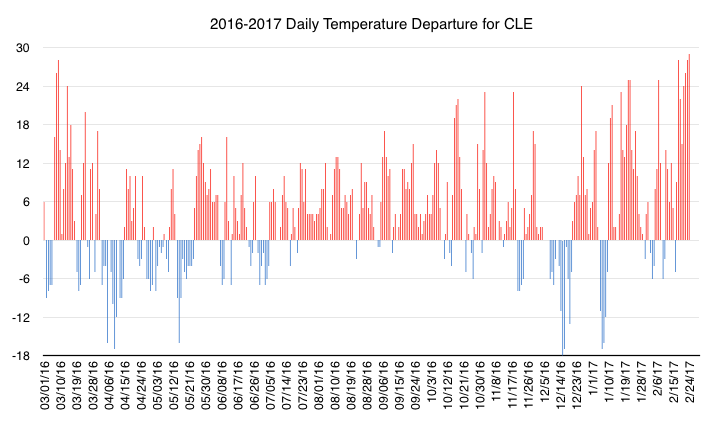
February 2017 highlights for Cleveland: Average high of over 50! Average low was above 32! 16 days had a high of 50 or above. 9 days had a high of 60 or above. This was essentially the most anomalously warm month on record for Cleveland averaging 3.8 degrees warmer than the previous warmest February.
-
Had 0.3" overnight. It was melted by 9:30am. It never stuck to pavement but that didn't stop the roads and sidewalks being coated in salt again! I'm feeling optimistic for March. It would be nice to at least get a 3" synoptic storm this season.
-
In summary, yesterday was the warmest day in Ohio in winter since records were kept. For comparison, since 1871, there have been 53 Fourth of July's in Cleveland that had highs of 76 and below. Yesterday was 77 degrees at both CLE and BKL! Here's the running 12 month daily temperature departures for CLE.