
Trent
-
Posts
2,813 -
Joined
-
Last visited
Content Type
Profiles
Blogs
Forums
American Weather
Media Demo
Store
Gallery
Everything posted by Trent
-
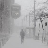
I thought the west side was finally going to score with this one. Add another 2-3” snowfall to the list.
-
DJF temperatures at CLE will end up right at the 30 year normals, it's too bad snowfall wasn't anywhere close to normal. If the late week storm follows seasonal trends, you can bank on there being 2-3" across northern Ohio with significantly more snow just 25-50 miles to the north.
-
February will likely end up tied as 7th or 8th warmest on record for Cleveland depending on how warm it gets tomorrow.
-
So the winters of 15/16, 16/17, and 17/18 will have all had a 70+ temperature in met winter in Cleveland. A 70 degree temp in winter in Cleveland is pretty rare by itself, let alone to string 3 consecutive winters with one. It’s funny how it’s now more common to see 70 degree days than it is to get a 6” snowstorm. This winter was so close to being good, but it ended up being another Detroit special.
-
Cleveland just cannot catch a break when it comes to decent synoptic events. It’s been years of miss after miss with perpetual 1-3” snowfalls instead. The airport is still running a 7” deficit on the season. Truly takes a miracle pattern to have normal snowfall these days. March 2008 was a decade ago already, and it seems the credit card it was put on still has lots more payments to be made.
-
It really is amazing how you could bank on a widespread 6-12" synoptic storm across NE Ohio almost every year or at least every other year. Now, it's becoming once every 8 years. CLE had a 3.7" seasonal snowfall deficit as of yesterday. It practically takes a miracle pattern just to get close to normal these days.
-
Watching these models the past few days emphasizes how incredibly difficult it is for Cleveland to score a 6"+ synoptic storm. Still plenty of time for things to turn around, but it would seem this will either end up being a run of the mill 3-6" snowfall or a narrow miss.
-
The irony of a cold and snowy end to 2017 is that 2017 still ended up being Cleveland’s warmest year on record. This coming off 2016, which was at the time, the warmest year on record.
-
No doubt that Erie got clobbered with an immense amount of snow, but I’m betting totals are inflated. ERI reported 54” at the 7 am update yesterday but the snow depth was only 28”. Seems awfully suspect. Perhaps it’s just the way the snow is measured by clearing a snow board and then it blowing back on the board. It’s kind of like going to a casino winning 500, losing 250, and then winning another 500. You walk out with 750 but you can say you won 1,000.
-
Right now 2017 is currently the warmest year on record for Cleveland. The cold snap this week might be enough to swap places with 2016 for record warmest. Nonetheless, the past two years have been exceptionally warm for Cleveland.
-
Impressive totals in Erie. However, I wouldn’t be surprised if the snow totals at the airport there are a bit inflated this month. Looking at the ERI December F6 they got over 20” without a thaw earlier in the month and their snowdepth never exceeded 4 inches. Later on the 15th and 16th they reported 13” new but the snow depth only went up by 3” to 7”? Seems suspect even considering the fluff factor of this type of snow.
-
I hope everyone enjoys their white Christmas! It seems not much has changed with the NW trend pulling another nice storm out from under Cleveland. One of these years the rare and elusive widespread 6”+ snowstorm will hit NE Ohio.
-
Turned out to be quite a wet May for Northeast Ohio. Temps managed to end up slightly above normal too after a cool 2 week period to start the month.
-
Impressive streak of below normal temperatures right now. This has to be the worst time of year for below normal weather too.
-
April 2017 ended up being the warmest on record in Cleveland. February, April, August, and December have all had their warmest month established in the past year and a half in Cleveland. September and November had second warmest months established. So half the months have had either their warmest or second warmest month established in the past year and a half in Cleveland.
-
This is starting to get borderline ridiculous, but this April is on track to be the warmest on record for Cleveland. I've lost count of how many top 5 warmest months have happened recently. The 12 month temperature anomaly for Cleveland is insane. When is the rubber band going to snap back to cold?
-
Not at home today, but traffic cams show no accumulation within a few miles of the lake.
-
This will be the first time in Cleveland that March has had an above normal temperature departure, but was still colder than February. In other words, March 2017 was warmer than all 147 Februarys since records were kept except for February 2017. It really shows how freakishly warm this February was.
-
Yeah. It hasn't been a good decade for snow here at all. CLE is running almost a 100" snowfall deficit the past 6 seasons, which is pretty incredible. To put that into perspective, if CLE had 16 more 6" snowstorms the past 6 seasons, there'd still be a deficit! 16-17 33.7" Deficit 15-16 35.4" Deficit 14-15 1.1" Deficit 13-14 17.9" Surplus 12-13 16.5" Deficit 11-12 29.3" Deficit Total 98.1" Deficit
-
Here's some data that illustrates how little snow has fallen at CLE the past two seasons: The past 2 seasons have only seen 67.3" of snowfall at the airport. A normal season would see 68.2", so thus far the past two winters combined into one would still be a below average snowfall season. Sadly, I think the airport measuring has been a bit generous the past two years as small events have been given straight 10:1 ratio totals despite little or no snow actually covering the ground. The previous lowest back to back seasons at the airport were 1978/79 and 1979/80 when only 77" fell those two years. Obviously there's still plenty of time for it to snow yet this season, but CLE is still running 9.7" below the previous back to back lowest seasons. Based on the outlooks the next few weeks, there'd have to be a miracle mid/late April blizzard that dumps 10"+ to move out of the bottom. It really is amazing how little snow activity there's been around these parts the past two years, especially the lack of even a minor synoptic snowfall.
-
Congrats. The radar looked great last night around that area. I was also surprised at how even with sub freezing temps the past few days how the snow still melted from the ground up. My driveway was mostly scoured clear by the wind, but when I removed some of the drifts it was all slush underneath.
-
Yesterday's 1.5" at CLE was enough to put this season's snowfall total just above last year. CLE is at 33.5" for the season, while last year it finished at 32.8". Interestingly the largest calendar day snowfall stands at just 3.6" this year. The last time it was that low was the 1969/1970 season. There's still a month left in the snow season, but the odds of getting an official 3" synoptic snowstorm this season are quickly dwindling.
-
The Exeter, Ontario radar shows the Lake Huron bands (currently multi banded) starting to look a bit better this hour. We'll see what that translates on this side of Lake Erie in the next hour. I'd imagine there won't be a single primary band here until those bands in Ontario consolidate first? I ended up with about 2" total from the synoptic last night and lake effect today. When you look back at all the "storms" over the past few years here, it really is astonishing the number that busted. This must be the most difficult place to forecast snow in the US, especially based on population.
-
It doesn't look like CLE will be adding that much to the seasonal snowfall total unless a Huron band decides to hit the west side later. I didn't really get that much snow after this morning (less than an inch). The radar looked way better than what was falling, but the heavier returns were just east and south of the airport. The guidance QPF for this event was extremely overdone. We're probably around 0.15" liquid on the west side. Edit: Perusing the webcams on Wunderground, there's one in Brookpark that shows the relative lack of snow near the airport/west side rather well. Looks like 1-2" on the ground at most.
-
It really is amazing how little it has to "weather" for things to close these days. No doubt there's much more hype and sensationalism with weather than there was before social media existed. The irony is that the snow we've experienced the last few years has been some of the tamest in several decades. Just imagine if we actually had a widespread 10"+ event! It sucks that the synoptic snow didn't reach its full potential, but model trends yesterday morning hinted at that. Unfortunately the hi-res short term guidance last night around 6pm started to look quite favorable, which proved to be overdone. But it is funny how hard it is to buy a decent synoptic storm around here this season. I'm not throwing in the towel just yet on the lake effect. Surely the favored locales will end up doing well. Radar looks great right now.

