
Trent
-
Posts
2,813 -
Joined
-
Last visited
Content Type
Profiles
Blogs
Forums
American Weather
Media Demo
Store
Gallery
Everything posted by Trent
-
Picked up about an inch with the band last night. Winds were really rocking with gusts over 40mph for a few hours. There's actually less snow in my yard than before it started snowing thanks to the wind sweeping the yard down to bare grass in spots.
-
Picked up an inch here. Nice to see it look like winter again to match the cold temperatures.
-
For the most part, the winter outlooks this season were quite favorable for these parts. That hasn't proved to be the case so far. That's what made last winter's synoptic failure a little more tolerable, since it was well known in the fall that winter was going to be a dud. Hopefully things turn around by mid month. Even in these somewhat boring patterns it always seems something minor tends to sneak in.
-
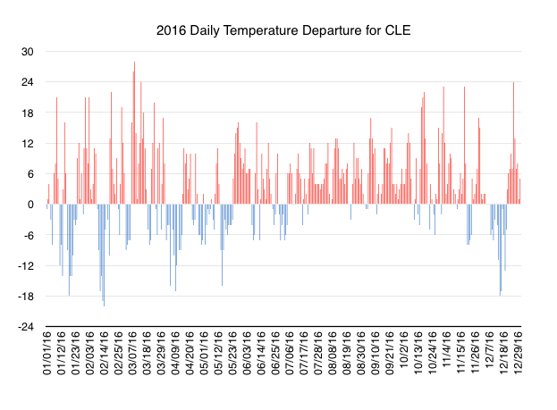
Here's the 2016 daily temperature departure for CLE, for the warmest year on record. The past 6 months have been rocked with continual warmth except for the mid December cold snap. Even with that cold snap, December will likely only finish 0.1 degree below normal for the month at CLE.
-
Even though I missed most of the snow, it's still fun to track these types of events. These are pretty much NE Ohio's "bread and butter" snowfalls, especially for the secondary snowbelts. Even though the snowfall totals might be a bit low, these types of events are much more reliable at producing snow than tracking a gulf low for a week. As for 2016, Cleveland has locked in warmest year on record. 2012 had an average temp of 54.09 and 2016 looks to come in around 54.25 give or take a couple hundredths depending on tomorrow's exact high and low. What that comes down to is if you took the same daily average temperatures in 2012, 60 days in 2016 would have been 1 degree warmer than 2012.
-
There have been a lot of great examples the past few years of how winter weather headline criteria just aren't relevant for properly warning the public. There's no reason a long duration light snowfall event deserves warning but a 3" per hour thundersnow band gets left out. I think some offices experimented with impact based headlines a few years ago, but I don't think anything came about from it. There almost needs to be some sort of "intense snow warning" a headline for whiteout conditions that may last a few hours, but keep accumulations below 4". It does seem that the public is craving simplicity in their forecasts, so perhaps the whole headline system needs to be redone. I also think it doesn't help that many headlines seem to be reactionary than forecast. The public wants to know what the weather is going to be the next day before they go to bed, or what it will be when they leave work. They don't want to wake up or leave work and see that they've been "upgraded" to a warning when it's obvious looking out the window that it's snowing heavily. People want to plan ahead so upgrading as conditions warrant does nothing to help in that regard.
-
Just a dusting here, heavy band developed just to the south. That band really means business though!
-
Things seem to be trending more favorably for tomorrow's event. It would be nice to get the ground covered again. Hi resolution satellite imagery this morning shows the western basin mostly cleared out with some slushy ice near the Canada side.
-
It's funny that CLE was finally able to secure a below normal temperature month (albeit only about -0.5) after months of record breaking heat, but snowfall for the month was still less than half of normal. At least the warm-up allows for an ice melt in the western basin. It keeps open the possibility for more impressive LES once the pattern changes again. I'm not one to really buy into the idea that a place is "overdue" for a certain type of weather. But, considering CLE's relatively high annual average snowfall, the number of large snows that have historically impacted CLE, and the number of major snow events over the past few years for nearby climate sites, the lack of big (or even moderate) snows the past 5 years at CLE is ridiculous.
-
The temp at CLE kept surging well after sunset to an unbelievable record high of 68 for the day, which also ties the warmest it's ever been for the last half of December in Cleveland. Warmth will not be denied this year.
-
Today's record warmth surely wiped out all of NE Ohio's snowcover except for driveway and parking lot piles. 65 at CLE breaks the old record of 64 from 1875. That has to be one of the oldest records still standing for Cleveland! Cleveland is still on track for a record warmest year as we count down the days to 2017. If the end of the week ends up being colder than forecast it might end up being a tie with 2012.
-
The past few days have been a good example of how temperatures above freezing don't really melt much snow if you don't have high dewpoints. We've spent almost 24 hours with temps in the mid to upper 30s and dews in the low to mid 20s and the measly 1 inch of snow cover hasn't budged. Saturday will probably wipe everything away on the west side. CLE definitely won't have a white Christmas, but I'm sure the primary belt will retain some snow through Sunday morning. 2004 was the last time CLE has had more than 1" on the ground at Christmas!
-
Brutal. Picked up about 0.60" of rain overnight with temps between 32.5 and 34. It turned into freezing rain at the tail end when temps finally dipped below freezing before finishing as a couple flurries. My snow pack is down to an inch.
-
Picked up a whopping 0.2" of snow overnight. There appeared to be a very fine glaze on top, so it likely ended as some freezing drizzle. Temps already safely above freezing and rising. It looks like some areas could get an inch of rain tonight before temps plummet again. It's amazing how difficult it is to get synoptic snowstorms to materialize around here, especially considering all the storms that have happened in the region the past few winters.
-
Models have really scaled back on the QPF for the event tonight and tomorrow. It doesn't take much freezing rain to cause a significant impact, so it could still be treacherous in the morning. However, I'm skeptical that 2-4" of snow is going to fall before the switchover to sleet, freezing rain, and rain.
-
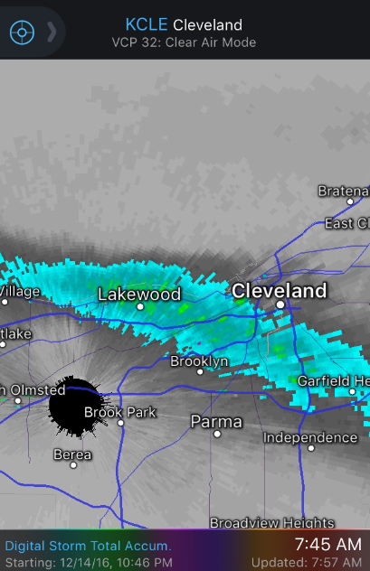
Good old lake effect snow ... it's half compacted/drifted away a few hours after it falls. I did get a couple pictures this morning, but it wasn't a very photogenic storm. Taken on a flat surface. There was about a trace - 1/2 inch of snow before the storm started. An unusual lake effect total precipitation jackpot over Lakewood:
-
That's what surprised me the most. Strong winds are terrible for lakeshore lake effect. But, there was a strong Lake Michigan connection with that band, which helped. I will say that this was certainly a unique and unusual lake effect event for downtown Cleveland and points west. Winds were consistently gusting over 40mph, with peak winds gusts well over 50. In fact, the local storm report has a 76mph gust just offshore downtown. Coupled with temps around 10 and white out thundersnow in excess of 2" per hour, this easily met official blizzard criteria overnight. It's too bad the synoptic storm for tomorrow night is looking more and more like rain. We'll probably wash away a lot of snow cover.
-
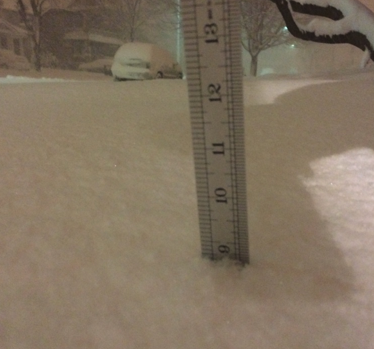
This makes me realize how easy it is for the Buffalo south towns to get those crazy 40"+ amounts. It didn't take that long for 9" to accumulate. You just need one of these bands to stay still for most of the day.
-
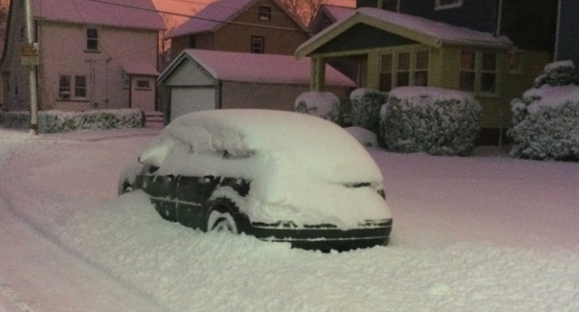
Almost 9" in Lakewood overnight.
-
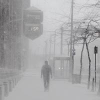
It's an unbelievable sight out there this morning. Now if only this band can become stationary for most of the day. A chilly 13 degrees outside with 1/16 mile visibility IMBY.
-
It seems they're going much more conservative with headlines for Cuyahoga County this year. It almost feels like they are doing headlines that are "county average" versus "maximum snowfall in the county" this year. It certainly makes it difficult for a county with over a million people that has drastically different weather by the mile. I'm optimistic here along the lakeshore, but I've quickly learned that no set-up is ever a lock for snow here. I think accurately forecasting lake effect snow accumulations for areas outside the typical high elevation primary belt is a much more difficult task than forecasting for a place like Chardon.
-
That's pretty much an ideal run for most of us on here. Let's hope it verifies.
-
Snow depth here is somewhere between a trace and an inch. Grass is poking through most lawns with a lot of bare patches. It's hard to believe that just a few miles away it's a completely different scene. The set up this week could be a rich get even richer LES scenario. Hopefully things end up being a little more south to spread the wealth. Nothing worse than an arctic cold blast and bare grass.
-
Certainly a frustrating start to winter here on the west side. Less than 2" from the lake effect event at the end of the week and a disappointing long duration 2" yesterday that ended up mixing with rain by the evening. We've been above freezing all night, which has eroded what little snow cover we had. It's weeks like this that make me wonder what kind of meteorological set ups CLE needs to get their ~68" average snowfall each season.
-
Things will have to move/redevelop considerably to the SW or else this will be another non-event for a good chunk of people. Last few radar frames look like it's wobbling north.
