Trent
-
Posts
2,813 -
Joined
-
Last visited
Content Type
Profiles
Blogs
Forums
American Weather
Media Demo
Store
Gallery
Everything posted by Trent
-
The last time CLE recorded more than an inch of snow was on March 1st of this year, which was one of the earlier ends to the snow season. With no significant accumulating snow on the horizon, it looks like they'll easily go over 9 months between 1 inch snowfalls. That's got to be close to a record.
-
I'll be curious to see what amounts come in. Radar seemed impressive for a few hours, but local webcams aren't that impressive. Perhaps the area around Mayfield and 271 will come in with an advisory total, but it looks like warm ground is melting the snow from below after the showers pass. We'll see when CLE records their first inch of snow for the season, but I have a feeling we'll be waiting a bit.
-
I had my first freeze of the season last night with a low of 31. BKL also had their first freeze last night too. Just a light dusting in Lakewood.
-
And Lake Erie is just getting warmer ... RECORD EVENT REPORT NATIONAL WEATHER SERVICE CLEVELAND OH 602 PM EST WED NOV 18 2015 ...RECORD HIGH TEMPERATURES TIED AT CLEVELAND AND AKRON TODAY... TODAY AT 511 PM EST THE TEMPERATURE CLIMBED TO 71 DEGREES AT CLEVELAND HOPKINS INTERNATIONAL AIRPORT. THIS TIES THE OLD RECORD SET IN 1954. TODAY AT 359 PM EST THE TEMPERATURE CLIMBED TO 70 DEGREES AT THE AKRON-CANTON REGIONAL AIRPORT. THIS TIES THE OLD RECORD SET IN 1958.
-
Possible record high tomorrow November 18th ... forecast is for 70, record is 71. Last year on November 18th, CLE had a record low of 10, the earliest such occurrence on record.
-
Lake Erie is a bath tub right now. Temperatures are running quite a few degrees higher than in previous years. Here along the lakeshore I've yet to have a first freeze. Wouldn't be surprised if that's still a few weeks off yet. I think lake effect this year will be a bit better than the past few years for these parts. That frozen lake the past two years really dampened what could have been some really amazing lake effect events.
-
With all these 70+ degree days and a generally mild fall, I can only imagine what the lake could produce when we get the first Arctic blast of the season. The buoy between Lorain and Pelee is reporting a water temp of 58 today.
-
Even along the lakeshore there were some intense graupel showers on Saturday. Still no freeze along the water, but Hopkins did hit 30 last night.
-
The modeling of the Joaquin remnants remind me of Sandy a few years ago. Could be quite the washout Sunday night and Monday.
-
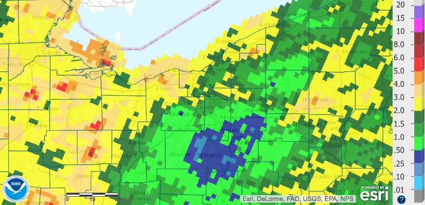
This is turning out to be quite the rain event, just as you predicted. There will definitely be widespread 3" totals. I went down to the lake earlier when some of the cells were about to make landfall but I didn't see any rotation.
-
Pushing 2" of rain here. It looks like the radar estimate totals are really under done. We'll see how much more rain we can pick up through the day.
-
Nice write up as usual! Some of the high resolution models are also spitting out 5"+ rainfall totals over the next 48 hours as well. It's too bad we can't have this happen in the winter months. It wouldn't shock me if most areas in northeast Ohio get more liquid equivalent from lake effect rain in any given year versus snow. It seems like every season we get 2 or 3 significant lake effect rain events of over an inch.
-
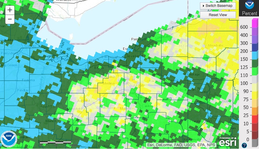
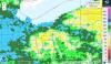
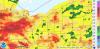
Here is the 90 day precip % of normal map for the region. This would be for meteorological summer. There was quite the spread with areas in NW Ohio and along the lake getting 150%+ of normal rainfall. Akron and Medina and points south didn't fare so well. Of course, it was June that made the summer wet as a whole, but take a look at the July and August % of normal:
-
CLE only hit a high of 62 today. Assuming it doesn't rise any during the late evening, this will tie the record low max of 62 back on August 26, 1910. Certainly felt very fall like. 62 is the normal high for October 18th.
-
Quite an event this turned out to be. Looks like several stations have had over 1.2" of lake event rain since the event started. Easily would have been widespread foot snowfall totals had this been a few months later.
-
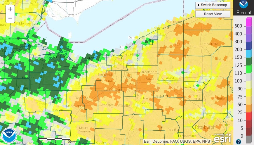
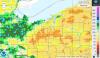
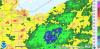
It sure was a rainy start to summer, but the rain faucet seemed to shut off in July. Here are the monthly maps: June July August A few areas with about 2" or less since July 1st. Northern Lorain and Cuyahoga seem to be the big winners for the summer in NE Ohio. Medina County really missed a lot of the action. There might be a few isolated spots in that county that had below average rainfall so far this summer.

-
I don't know if anyone else has seen this in the news lately, but the FAA is investigating CLE's snow removal operations. Apparently the airport had been significantly understaffing itself versus federal regulations during winter weather. I wonder if this helps to explain why CLE has such erratic snowfall measuring totals? It often seemed like totals were made up or were revised the following week. It wouldn't surprise me if they weren't even measuring the snow or perhaps they were falsely under reporting snow so that it didn't trigger higher staffing levels. I doubt the accuracy of snow measurements is the greatest of the FAA's concern versus proper runway maintenance during snow events, but it will be interesting to see what comes of this.
-
Yeah. Quite the turn around. I've only had about 0.10" of rain the last two weeks. Lake breezes have been kicking in daily and keeping temps from getting to 90 at the airport.
-
After today, I've had over 11" of rain IMBY for the month of June. The official rainiest month on record for Cleveland is 11.05" in September 1996. Needless to say many areas likely just saw their rainiest month on record, despite the airport only getting 8-9". It's even more impressive when you consider the 3 inches or so that fell the last days of May. So many areas are pushing 15" of rain the past 35 days, some incredible amounts for sure.
-
Just incredible amounts of rain. Well over 2" today for most areas. Lots of places with over a foot the past 30 days too. The airport hasn't had as much, but still enough to be 6th rainiest June on record. What's interesting is that 2013, 2014, and 2015 will all make it on the top ten rainiest Junes list. There've been a few months over the past 5 years or so that have had dry periods, but looking at the overall time frame, Northeast Ohio has been in an incredible wet spell.
-
Quite the lightning show last night. I've had close to 10" of rain the past 30 days.
-
Still no measurable precip for CLE this month. High res models over the past two days consistently showed a washout with over 3" of rain. I can't remember seeing forecasts of heavy rain and 90%+ probs over a 2 day period with nothing more than a trace materializing.
-
Wow. I see some personal weather stations near Strongsville had over 5.5" today and yesterday. I wound up with between 2.5-3", definitely the rainiest day in a long time.
-
The northern strip of counties from Cleveland to Toledo were added to the "abnormally dry" category in this week's drought monitor. The airport just lucked out on Monday getting grazed by that thunderstorm, while areas just a mile to the west had no more than a few tenths.
-
Only 0.89" of liquid equivalent the past 30 days at CLE (some of that was actually snow). The daily max in that time frame has only been 0.14", so it's been a lot of light rain events where the ground doesn't get saturated. Considering the driest April on record is 0.65" and second driest is 0.99", this is an impressive dry stretch for the area. With the dry ground, it's not surprising most areas were able to torch to around 90 yesterday.