
Trent
-
Posts
2,813 -
Joined
-
Last visited
Content Type
Profiles
Blogs
Forums
American Weather
Media Demo
Store
Gallery
Everything posted by Trent
-
I'm guessing just like last weekend that the KCLE total gets updated at midnight. It's quite apparent that 0.16" liquid didn't fall just by looking at the METARs and the 2.7" was probably achieved by 9am, since both the 8 and 9 am obs each showed 1 inch new snowfall. I wonder where these numbers on the climate report come from? The nightly local storm report will also have this storm cut in half depending on when the observer measured this morning. It sure makes finding storm totals difficult.
-
A little over 4" here. Seems to have performed as expected. I'm more surprised at the fact that the warm air was over modeled. Only up to 26 today unless there was an intra-hour high. All in all I've had almost 30" of snow this month. I think I can say that the past 30 days have probably been about the best you can get in these parts for a winter weather enthusiast. CLE had 0.36" liquid equivalent today adding up each hourly observation, they also had 2 hours with at least an inch reported. I'm guessing they should come in with about 4" as well.
-
CLE reporting inch per hour rates the past two hours. Nice snowfall even if it's not huge fat flakes. CLE should end up on the top ten snowiest February list once again, even with their low ball snowfall measurements.
-
I wonder if CLE will go ahead and issue advisories for a 3-5" event? It's sort of borderline. What amazes me most is that we've had snow event after snow event accumulate without much melting. Even if we only get 4" of snow tomorrow, that 4" of synoptic snow will push all the snow banks higher which are already impressive.
-
It's amazing how much model disparity exists for this storm tomorrow. I think we sit good for 4-6". I wonder if we'll see an inevitable NW trend with this?
-
Nice bump on the SREF plumes. CLE with a mean of over 4", but a nice cluster of 6 members in the 6-9" range. Still decent potential in these parts as we get within 36-48 hours.
-
Trends for the weekend storm have been positive for us. Positive is a relative term though. Even if the storm ends up being weak and southeast, it's much better than torching into the 40s with an inch of rain as a strong low passes to our north and west. By keeping this storm to our southeast we also keep temperatures down enough to keep the coldest February on record in play. We should be able to break today's record low at 11:59pm and tomorrow's looks like a lock. That would be 5 record lows this week.
-
Surprised to see the lake effect machine kick in overnight. I'm sure the favored areas picked up several inches. Even the airport looked to get in on the action. They even reported 0.03 liquid in one hour with single digit temperatures and visibilities below a half mile.
-
Nice short lived "white out band" rolling through right now to keep the snowpack fresh.
-
You don't even need to read the storm threads to figure out trends. If the the main thread has little or no new posts after the latest models, it means there was a nice hit for Ohio. If the thread has lots of new posts after a model run, it means it has trended NW. Nice snowfall this afternoon. Enough to freshen things up.
-
Yeah. Being in a GFS bullseye this far out is never a good sign. Nonetheless it's nice eye candy. However, I like where we sit at this point. I do wonder if a frozen Lake Erie will have any impact as we get closer? We usually can rely on some slushy areas or large cracks, but after this cold spell and the cold predicted later this week, that's probably off the table. Perhaps if we do get a low that rides close to NE Ohio, like earlier this month, the frozen lake could help keep temps down a bit for the lakeshore areas. It would be extremely painful to watch this cut to our NW after having record cold the week prior and more cold afterwards, but such is winter reality for Ohio.
-
Another day, another record low. That's 3 in a row for CLE.
-
I saw a couple personal weather stations in interior NE Ohio dip below -30. Quite a few spots in the -20s. The -12 at CLE was the 5th coldest February temperature on record and only one day has been colder than that later in the season. I'm curious how much open water and cracks will appear on Lake Erie with some shifting winds. The Modis image yesterday showed most gaps filled in.
-
The F6 for KCLE shows 5.2" of snow yesterday. I can live with that total as being reasonable. It didn't get as cold as anticipated overnight. A lot of guidance had temperatures below zero around 8pm last night, but it took until the early hours this morning to finally dip below zero (at least for coastal areas). Very unusual to see BKL actually colder than CLE in winter on NW winds for an overnight low. CLE will have a second chance to break today's record low just before midnight, probably achievable. I'm eager to see what MODIS imagery looks like today and tomorrow. There can't be that many gaps left in the ice.
-
I have 6.1" today. And for the benefit of the doubt it was hard to measure later in the afternoon. Granted, the snowfall last night was pretty easy to measure as it was super high ratio fluff. Up until noon the additional snow to measure was pretty easy as well. After that the 40mph gusts came in, which made things very tricky. If you didn't measure at all today and went outside right now to try and figure out an accumulation, then you're going to have a very "off" total. The airport, which is completely open, probably was going to have difficulty measuring regardless. The little bands that keep sliding in off Lake Erie are depositing very fine accumulations. It's definitely treacherous out there.
-
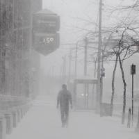
One of the those lake effect bands just hit me. Super fine snow that doesn't really accumulate, but it's dropping the visibility below a quarter mile. It just looks like a fog of snow out there. With temps now in the single digits this stuff isn't going to melt from the roads. This might actually end up being one of the most high impact snowfalls of the season here.
-
Yeah, this was well advertised by you and the NAM and GFS had been consistently showing more than 6" for the eastern suburbs for days. There was no excuse to play down this event. Even I was optimistic about this event! The climate report from KCLE shows a laughable 2.5" of snow today. It's almost cringe worthy. I was thinking a lowball total of about 4", but 2.5" is a joke. Since 0.9" was recorded at 7 am, that means only 1.6" fell during the day today. It's sad that's what gets "officially" recorded. I know I jokingly said earlier that we officially need 20" more snow this season to reach normal which means we actually have to get closer to 30" but that's the reality. Even DTW had 3.3" from this. So you're trying to tell me that DTW had more than CLE from this event? And here's the radar loop of this event, yet 2.5" of snow from this with temps in the low 20s? Impossible. http://weather.cod.edu/satrad/nexrad/index.php?type=CLE-N0Q-1-200
-
Well, the winds started whipping pretty good with the wind shift. If you didn't measure an hour or two ago, then your measurements will be completely off. I'm really curious what kind of joke snowfall totals KCLE reports today. I just don't understand why those advisories weren't just issued yesterday. Significant snowfall and extreme wind chills are two separate and distinct weather phenomena.
-
Snow has increased again along the shore. We'll see how long it lasts. With temperatures plunging below zero by the evening, it's going to be extremely treacherous. There's an outside chance that tomorrow's high will actually be colder than the record low for the date of -4.
-
The accumulated precip maps show a swath of 0.3" liquid equivalent stretching along I-90 from Lorain County through downtown. There's even a small speck of 0.6" near Lorain. Considering what's fallen here, there must be a hefty total under the speck.
-
Likely measuring problems at KCLE as the METAR didn't even have the "SNINC" mention. I was thinking they should have had 2" in the last hour. KCLE 141651Z 35017G23KT 1/4SM SN FZFG VV005 M07/M09 A2960 RMK AO2 WSHFT 1551 SLP035 BLSN P0002 T10721094 $
-
Up to 5" on the dot here. Snow band seems to have shifted south of the immediate lakeshore. I hope KCLE accurately captures this snowfall today.
-
I don't like to exaggerate, but this might be one of the heaviest snow rates I've experienced. Just incredible.
-
Absolute white out there now. I'm up to 4.6". Just unbelievable there isn't an advisory out for this.
-
Radar has just exploded. Huge fat flakes falling.

