
Trent
-
Posts
2,813 -
Joined
-
Last visited
Content Type
Profiles
Blogs
Forums
American Weather
Media Demo
Store
Gallery
Everything posted by Trent
-
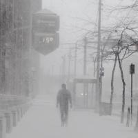
Picked up 2" of fluff overnight. This is super high ratio fluff. Can't wait to see what KCLE comes in with for an overnight total, likely a trace since the METAR didn't report any liquid equivalent. Radar looks good for the main show about to begin shortly.
-
I tend to agree with you OHweather. Many times advisories get issued once an event has begun and it looks bad. But at that point, it's not very advising. It's best to let people know they need a head's up. The problem is that 2-4" of snow with wind and temps falling below zero is completely different than 2-4" of snow at 32 and calm winds which is different than 2-4" of gentle lake effect fluff, which is different than 2-4" of synoptic snow at 22 degrees from a bombing low. General public just sees a snowfall total and makes a judgment based on that without realizing that accumulation doesnt equal impact of the snowfall.
-
I'm amazed that last night's temps didnt re-freeze those open areas. That water is 32 degrees, surely by Monday morning the lake will be shore to shore ice. I'm optimistic for tomorrow. SREF plumes, for what they're worth, show decent precip. Perhaps the lake will contribute more than modeled. I don't think the models handle these odd events with ample ice cover all that well. Could be some surprises that bust good or bad. Sunday looks interesting. We might fall below zero by midnight Saturday so there's a chance we stay below zero all day Sunday. Could be one of the coldest days in quite some time, even surpassing last winter which saw the lowest max of 4 degrees.
-
Hit 1 degree IMBY. Definitely a bit of lakeshore influence. I'm hoping tomorrow over performs, snow pack in my area still looks pretty ugly. 2-4" of powder would really freshen things up. I think officially CLE went down to a trace for a few days in January, but I (and everyone else) has had solid snow over since the beginning of January. We might actually see a 2 month continual stretch with snow on the ground.
-
The record low at CLE on Sunday is one of the warmer for February at -4. That seems to be pretty much a lock at this point to be broken. CLE still needs 20" more snow this season to hit normal, which means we actually have to get 30" to hit normal based on airport measuring techniques.
-
Just a dusting IMBY. Looks like some enhanced orographic snows in the secondary snow belt this morning. Last year's cold snap happened in early January when the lake was still mostly ice free and resulted in a rapid freeze up. I'd imagine this cold snap, occurring with a lake that's already 90% iced over, might result in temperatures a bit colder than modeled, particularly for coastal areas. The satellite shots of Erie next week should be quite impressive. I would like a good 2-3" of fresh powder to clean up the snow pack. It still looks pretty grim out there. At least it looks like quite a bit of opportunity over the next few weeks.
-
I'll be very curious to see what the lake can contribute in this type of frozen set up. Then again after last week's snow blitz, a few inches over the next day or so hardly seems noteworthy. With the arctic blast this weekend, I'd imagine most holes in Lake Erie will have frozen solid again. The storm on the 17th seems very interesting.
-
Last night's GFS says next week will be fun across northern Ohio. On Sunday 850 temps plunge to -30C, haven't seen that in decades. That's followed by a 988 low skirting north of the Ohio River, which deposits two feet across the area. That's the epitome of a weenie run!
-
Snowpack seems pretty resilient. Temps are creeping into the mid 40s now though. It should freeze up solid by tomorrow. Hopefully some refresher snows this week as it looks pretty ugly out there.
-
This is probably the snowiest week of my life! Yesterday was incredible. Almost 8" of synoptic snow from two separate systems in one day. Impressive. And the 4.8" total for both systems at KCLE is probably a good 2-3" too low. The KCLE depth is also a joke: ...CUYAHOGA COUNTY... BROADVIEW HTS 21.0 700 PM 2/04 SNOW SPOTTER 1 SSE PARMA 18.5 1015 PM 2/04 SNOW SPOTTER LAKEWOOD 18.0 900 PM 2/04 SNOW SPOTTER CHAGRIN FALLS 17.5 530 PM 2/04 SNOW SPOTTER CLEVELAND-W SIDE 16.0 715 PM 2/04 SNOW SPOTTER GARFIELD HTS 15.0 645 PM 2/04 SNOW SPOTTER EUCLID 14.0 945 PM 2/04 SNOW SPOTTER CLE AIRPORT 9.0 700 PM 2/04 SNOW SPOTTER ...GEAUGA COUNTY... BURTON 19.0 845 PM 2/04 SNOW SPOTTER MONTVILLE 19.0 500 PM 2/04 SNOW SPOTTER CHARDON 18.5 730 PM 2/04 SNOW SPOTTER CLARIDON TWP 18.0 1019 PM 2/04 SNOW SPOTTER
-
These bands are ripping with the lower temps. I'm at 7" for the day already with almost 4.5" this evening. Definitely warning material conditions out there. 17" depth now.
-
Appears some lake enhancement is trying to develop as the main swath slides south and winds shift. My snow depth just broke last year's max depth of 16 inches.
-
Wow. What an impressive event. Easily 3" in 3 hours. Should have 6" for the calendar day shortly. KCLE reported inch per hour rates for at least 2 hours. I wonder if the airport will have difficulty adding two separate storms in one day for a final daily total? With the measuring problems they have, I wouldn't be surprised. The afternoon climate report showed 2", so there should be another 2-3" on top of that since then.
-
The rules for warnings and advisories are bizarre. Let's say that the exact same snow overnight was lake effect and 2-3" fell before dawn and then the bands shifted before expecting to fall back into the area this afternoon and drop 3-4" more. Advisories certainly would have been issued if not warnings. It seems unusual to have 2 separate "decent" snow events separated less than 12 hours apart. Most places will have a calendar total of 6" today easily, of course CLE will have 3". The snow out there now is pretty intense, I'd imagine rush hour commute will be pretty bad in an hour.
-
CLE coming in with 1.5" last night on 0.13" liquid. Don't buy that at all. An 11:1 ratio last night is a complete joke. I'm amazed because the snow measuring in November was pretty accurate, it fell off a cliff the past 2 weeks. Their 8" snow depth is also a complete joke.
-
What's amazing is that it doesn't even look like it snowed 3" overnight. The snow was so deep and coating everything beforehand that the new snowfall seems barely noticeable. Some models are hinting at 4-6" tonight. Theoretically we could have been under a winter storm warning as several areas will likely meet the 8" in 24 hours criteria.
-
Clipper has appeared to perform slightly better than expected. I'm betting most will wake up to 2-4" from Cleveland and points east. I don't even want to see what KCLE will report. Snow started just before midnight and they had 0.04" liquid equivalent through midnight, amazingly with this super high ratio fluff, they only marked down 0.4". Unbelievable. I don't think any measuring happens there anymore.
-
If only we could lock in the Euro for the next 7 days. The snowfall maps from the New York sub forum have a swath of 2-3 feet from Cleveland to NYC through next Tuesday. The Sunday storm looks most impressive. We'd easily have a 30"+ snow pack come next week if everything verified.
-
Yeah. The storm totals is completely inaccurate. They would have to add the 7-9am obs from yesterday, the 7-9pm obs from yesterday night, the 7-9am obs from this morning, and the 7-9pm obs from tonight which have yet to be sent out. There's a 2 hour window that spotters are supposed to measure everyday. That's why there's often such wild variations in the 12 hour reports. A quick hitting snow from 5-9pm is going to show up in the full total for some places and others it will be split up and shown the next day. I can understand this set up for long duration lake effect events, but for many other events it makes storm totals pretty difficult. Many times spotters might only email part of their storm total for a 12 hr window and the other 12 hrs might not have been emailed and hence doesn't show up online. It doesn't mean no snow fell, but to anyone perusing these it makes it look like a lot less snow fell.
-
The measuring at KCLE is such a joke. The report today lists just 0.9" of snow. You're telling me that 7 hours of visibilities under 1 mile and several lake effect squalls and that's it? Such a shame that's what goes down as official.
-
Lakewood and west side getting absolutely dumped on by that band. Will probably have over a foot "storm total" Airport was getting hit nicely as well so we can see how terribly they measure again today.
-
The band near Lorain has a definite Huron connection. I wonder if it will stay in one spot for long? If that moves just a nudge to the east it'll be over the airport so we'll what kind of Obs they report.
-
We basically got the same amount of snow as northern Illinois and southern Michigan, the only difference is that their snow had twice as much air as ours. Areas closest to the lakeshore definitely won out as temps were coldest there. I probably had slightly better ratios than a few miles inland which could account for an inch or two more. After what seemed like a big bust yesterday morning, it was great to see the storm pan out. I was watching a local station yesterday morning and saw they had lowered forecasted totals to 4" for Cleveland and 1" for Akron. But as of early morning yesterday that seemed likely. It's nice to get a storm like this. Definitely one of my more favorite storms. It was also nice not having to fight dry air intrusions, the radar constantly kept back filling with great returns.
-
CLE and BKL did report some light freezing rain last night at the tail end but temps at that point were already into the 20s. IMBY, I didn't notice any crust on the top of the snow, there might have been some light drizzle, but it probably didn't last long to the west. This will make an incredible base of snow. Now that the cement is freezing solid, there should be minimal settling of the snow. And with several more snow chances this week, we look to build up nicely. I can't believe that KCLE is reporting only a 7" depth this morning. I easily have over a foot, and you have to struggle to find areas less than 10" in the typically sunny and drift prone spots. It's amazing that we've gone almost a complete month without melting down to bare ground. We couldn't even say the same last winter!
-
I'm curios what the official total will be at CLE. I have low confidence in any accuracy of measurement. The snowfall overnight and enhanced lake effect this morning was super high ratio, so theoretically CLE should have had a few more inches since midnight. Interestingly CLE reported 0.72" on the METAR adding up each hourly observation. The snowfall was 7.2". I'm fairly certain they just took whatever the METAR reported and applied a straight 10:1 ratio. We all know in winter storms that those hourly totals are wrong. Doubtful they'll do a core sample for the real precip or actually post a real measurement.
