Trent
-
Posts
2,813 -
Joined
-
Last visited
Content Type
Profiles
Blogs
Forums
American Weather
Media Demo
Store
Gallery
Everything posted by Trent
-
Wow. Way too early for this kind of heat. This coming off record cold, feels exceptionally hot. ...RECORD HIGH TEMPERATURES ACROSS NORTHERN OHIO... AT 448 PM EDT (348 PM EST) THIS AFTERNOON, THE TEMPERATURE AT AKRON-CANTON REGIONAL AIRPORT REACHED 88 DEGREES. THIS BREAKS THE OLD RECORD HIGH OF 86 DEGREES LAST SET ON MAY 8 1936. AT 312 PM EDT (212 PM EST) THIS AFTERNOON, THE TEMPERATURE AT CLEVELAND HOPKINS INTERNATIONAL AIRPORT REACHED 89 DEGREES. THIS BREAKS THE OLD RECORD HIGH OF 88 DEGREES LAST SET ON MAY 8 1889. AT 405 PM EDT (305 PM EST) THIS AFTERNOON, THE TEMPERATURE AT MANSFIELD LAHM MUNICIPAL AIRPORT REACHED 87 DEGREES. THIS BREAKS THE OLD RECORD HIGH OF 86 DEGREES PREVIOUSLY SET ON MAY 8 1936. AT 418 PM EDT (318 PM EST) THIS AFTERNOON, THE TEMPERATURE AT TOLEDO EXPRESS AIRPORT REACHED 88 DEGREES. THIS TIES THE OLD RECORD HIGH OF 88 DEGREES LAST SET ON MAY 8 1979. AT 411 PM EDT (311 PM EST) THIS AFTERNOON, THE TEMPERATURE AT THE YOUNGSTOWN-WARREN REGIONAL AIRPORT REACHED 89 DEGREES. THIS BREAKS THE OLD RECORD HIGH OF 88 DEGREES PREVIOUSLY SET ON MAY 8 1936.
-
Very sharp cut off to the rain overnight. It's been an exceptionally dry spring compared to the incredible wet spell we've had the last 3-4 years.
-
Climate report shows 0.7" at CLE. While these always get revised, that puts CLE at 67.0" for the season, still "officially" a hair over an inch below normal.
-
And just when you thought spring was firmly in place, the 6z GFS pops a snowstorm with some accumulating snow at day 11 over NE Ohio.
-
Had a light dusting of snow overnight that has since melted. That should do it for the snow season. It was definitely a short intense winter. You basically had 1 week of winter in mid November and then another 5 week window from late January to the end of February. All of December, the first half of January, and March were a dud. This past March was one of the worst March's in memory. If it's going to be 4.5 degrees below normal, it might as well have some snow storms. It looks like March 1st will end up being CLE's last inch of snow for the season, which is incredibly early.
-
12z NAM coming in with a decent hit for NE Ohio. A nice 3-5" stripe up to Buffalo.
-
CLE needs 1.9" to hit the seasonal average. It's definitely possible tomorrow night. These late season storms can easily turn all rain or surprise with an earlier switch over. Sadly CLE is well over 70" for the season, but because several events were never recorded this winter (or adjusted weeks after the fact to 10:1 ratio) the "official" total is much lower. But it would be nice to get a few inches tomorrow night so that CLE can officially hit average for the season. This is the same storm that models have been hinting at for a good 10 days now. There have even been some fantasy runs last week showing a 2' blizzard. The consistency of showing some snow from Cleveland northeast to Upstate and Western New York has been noteworthy.
-
10 members on the latest SREF plumes have over 3" of snow at CLE for tomorrow night. We will have the advantage of it occurring during the overnight period, so it might help with accumulations.
-
Friday night still looks like it has some potential, but the trend hasn't been too favorable for a major event. Nonetheless, could squeeze out a few inches across interior NE Ohio. CLE's last inch of snow was on March 1. The last month has been weather torture, 4.5 degrees below normal and no snow to show for it. The problem with spring in these parts is that it's often a dreary 2 month period of overcast 30-50 degree weather. Mid March through mid to late April is the worst time of year, weather wise, in my opinion, especially with the nasty lake breezes.
-
Just a couple tenths here yesterday, but enough to coat the ground. If the snow had been during the evening and overnight hours, it probably would have accumulated better. Still looks like a possibility for a storm next weekend. Otherwise this March, like almost every other early spring, has been awful. No meaningful snow to enjoy any outdoor activities and not warm enough to go out and enjoy it.
-
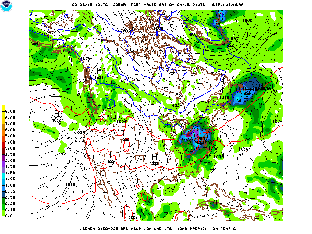
The 12z GFS did provide some eye candy for us in NE Ohio at hour 225. If were gonna get a blizzard at the end of season, might as well go big!
-
I really thought we'd wind up with at least a dusting of snow. Still a good few weeks left for snow opportunities though. But the way it looks now, the measurable snow season has appeared to end on March 3rd.
-
Looks like a chance for some light accumulating snow at the end of this week and weekend. CLE still needs a few more inches to hit average for the season. It would be extremely rare and unusual if we end the season without any more snow. It's been impressive as it is, that we've been void of measureable snow the past 3 weeks as March typically averages over a foot in Cleveland.
-
Awesome aurora display last night. I've never seen them from Ohio before and they were pretty impressive to the naked eye over Lake Erie. I'll have to tally my seasonal total, but I think I'm a little over 70" for the season. It was definitely a unique winter with almost no December snow. I wonder if that's it for the season? If that's the case, that'd be one of the earliest times the last inch of snow fell in a season.
-
What a stretch of winter. It's really hard to imagine we were able to string over 2 months without bare ground. You can almost always expect a torch every 2-3 weeks in these parts to melt the snow back to grass. We'll probably end up around 70-75 days of continual snow cover, which is very impressive. I'm still hoping for a late season big dog storm, or at least 3" so that CLE can officially hit normal for the season. In fact, CLE still averages another 14" of snow from this point on in the winter season. It's also hard to believe this winter ended up colder than last, even with the mild snowless December.
-
The F6 for that snow storm a few Saturday's back was just updated and a straight 10:1 ratio was applied, which is still underdone, but not as off. CLE just needs 2.5" more snow this season to hit normal. The last 30 days or so will really be one of the most memorable stretches of weather in Cleveland. The spring lake breeze season is bound to be a brutal one again for lakeshore areas.
-
What is wrong with the measuring at CLE!? I seriously doubt they had only 0.3" of snow yesterday. Every spotter in Cuyahoga County had over an inch. They have under measured this year by a good 10". It's like some person who hates snow is measuring and it makes them feel better by constantly under reporting what falls.
-
Even with CLE's shoddy measuring, this will still end up being a top 10 snowiest February. It should be the second snowiest February, but will end up being around 7th snowiest. Regarding the glaring inaccurate snowfall measurement on Saturday, the F6 shows a depth at 7am on the 21st of 9". The snow depth at 7am the day prior was 6". That means the entirety of the 2.7" that "supposedly" fell on Saturday occurred by 7am and that no more snow fell the rest of the day. This month is still on track to be the coldest February on record and second coldest month on record.
-
BKL had a low of -13 while CLE had a low of -5 last night. That BKL temperature for this late in the season is absolutely incredible. If there were a separate records list for downtown, that -13 would obliterate any record for the last 3 weeks of February. It's unfortunate we couldn't have cooled down a little bit earlier last night, we are stuck with a midnight high of 15 today. Otherwise we could really end up smashing the coldest February on record.
-
Today's high resolution imagery of Lake Erie should be the most impressive satellite shot ever taken of the lake. The low resolution visible shot this morning shows wall to wall ice and no thin spots.
-
Plugging in forecasted highs and lows and accounting for expected midnight highs and midnight lows CLE should come in with the coldest February on record and second coldest month on record. Only January 1977 would be colder. Had some of these cold fronts come through a few hours sooner it could have helped tremendously as there were a lot of midnight highs. The snowfall on Saturday still hasn't been updated which is annoying considering this will be the most historic month in many people's lifetimes in terms of cold and snow. Such a shame that it's not being accurately recorded.
-
I never would have thought that BKL, which sits right on Lake Erie could dip down to -10 with a NW wind.
-
Another day another record low. Ended up with 2" of new snow last night which brings me up to 32" of snow this February already.
-
Wow. The snow band rolling in now with the wind shift and front means business. Was not expecting any accumulation this evening, but appears there'll be a quick 1-2".
-
Yeah. That's complete BS. That will probably be adjusted at some point this week I would hope. But it proves the point that snowfall measurements at KCLE are likely made up, not measured at all, estimated, or not taken seriously whatsoever. It's a shame. Here's some liquid equivalent and snowfalls from yesterday: 2.1" on 0.15" TOL 2.7" on 0.38" CLE 4.8" on 0.35" YNG 6.2" on 0.43" CAK 6.8" on 0.52" CMH Ratios ended up being pretty good across the board. There's no way CLE only got 2.7". Judging from other official sites ratios and totals that came in from Cuyahoga County, CLE should have had about 4.5" give or take a few tenths. The 9am METAR was the second hour in a row of 1" per hour snows and showed a 8" depth. It had snowed 2 hour priors to that as well. The snowfall at CLE should have been about 2.5" at CLE by 9am. That means that the following 0.20" liquid equivalent that fell after that in the 20s was a straight 1:1 ratio snow, in other words pure ice. We'll see if this ever gets fixed.