

CoraopolisWx
-
Posts
2,918 -
Joined
-
Last visited
Content Type
Profiles
Blogs
Forums
American Weather
Media Demo
Store
Gallery
Posts posted by CoraopolisWx
-
-
1 minute ago, Ahoff said:
Yeah, GFS isn't messing around. Still putting out around 10" for us. That is probably high, but the potential must be there.
Wonder when NWS will start putting out totals? Probably not until late tomorrow at earliest is my guess.
Maybe the GFS is seeing a jet streak to enhance totals, along with the higher ratios ?
-
 2
2
-
-
21 minutes ago, windycutter said:
Has anyone/Mets mentioned the lake effect aspect of this storm?
If at some point we can get a Huron-Erie connection, it could be decent.
-
19 minutes ago, Burghblizz said:
Not all cutters are created equal - I don’t think this is about willing it to the east.
It’s more about intensity and timing. West could be best.
We could have crashing temps with SW winds because of how wound up this is.
Meanwhile, places just east of the track (including as far north as Ontario are raining). Different evolution, but our biggest storm ever (11.1950) did something similar. That’s why I think we have a better than normal chance of having more precip when the cold air gets there.
The GFS then wants to retrograde it and prolong the snows. That’s what it basically gives us a foot.
So no, it isn’t likely. And no it’s not Nov 1950. But I wouldn’t punt yet just because it cuts.
Yeah, as long as we can keep that mid level moisture wrapping behind, the existing energy could produce some decent fluff with the crashing temps.
-
12Z GFS Kuch likes us again.

i'd be happy with half.
-
2
-
-
Looking like a classic undercut storm, were areas further SE of the low will change over faster, than folks closer to the path of the low.
Just a matter of how much moisture wraps in behind ? -
Same here, woke up to a surprise covering.
Looks like around 530 a rogue band moved through the south hills.-
2
-
-
44 minutes ago, Ahoff said:
It's 5 days before it affects us. Models are not infallible which is clear with the inconsistency they've shown. Believe me I never for a second bought the 30" from the GFS and that's not what I am suggesting in possible moves back east, but to just say only 1" maybe is not certain at all at this time. I'm good with a few inches too, and that looks possible.
Yeah, with so many moving parts, still in play for anything.
The ENS means are still pretty solid last time I checked.
Kinda interesting with all the separate pieces of energy.-
1
-
-
9 minutes ago, Rd9108 said:
Gfs is about to show about the best storm we possibly could get here.
An Ohio Valley special for sure.
-
P14 looks the most realistic best case scenario.
Has that classic sharp cutoff to the NW. -
1 hour ago, Ahoff said:
More torture is beginning. The Weather Channel point and click has 7"-9" for the 22nd-23rd storm.
1 hour ago, jwilson said:Yeah the Euro is in-between the Canadian and the GFS. Miller Bs are always threading-the-needle for us, but if we can get the primary to come into the CONUS further south that would help.
For example, the CMC has the vort centered over St. Louis on the 22nd. The GFS has it centered over International Falls, MN. That's a massive difference.
Yeah, keep those H5 and H8 vorts south of us, and at least we have a chance
-
1
-
-
6 hours ago, RitualOfTheTrout said:
Yeah, I'm enjoying the great fall weather, but totally ready to shift gears once mother nature decides to flip the switch.
Looks like maybe a good soaking for the area with tropical remnants. Why can't we get a storm like this as all snow in winter?

That 1/17 storm had potential, just didn't have the mid level cooperation. SMH
-
1 hour ago, dj3 said:
Just had a brief burst of rain/snow/graupel move through Robinson.
Same here, a bit afterward.
-

Looks like a hybrid/Miller B snowstorm map.
Yellow is the 12"+ area.
-
1
-
 2
2
-
-
35 minutes ago, Burghblizz said:
This setup is 24” in February.
Maybe next winter we get a 1/17/22 redo, without the messy mid levels a la 1/4/1994.
Although my gut tells me we're more likely to see the next monster come from a 2/5/10 hybrid type setup.
-
Hard to be disappointed in April, but was hoping for some snow tv today.
The stronger CAD flow warmed the low levels a bit to much unfortunately.
Hopefully we get some flakes tomorrow. -
35 year revenge storm.
4/4/87 was the first of many disappointments for a young lad.
Went to bed that night with snow and a WSW, woke up to rain and a flood watch.
-
Nice rates with that line moving through.
Snow globe outside

-
Just got in from a measurement/walk. Averaged about 7.5-8” here in Mt Lebanon.
Nice squall conditions out there, probably should’ve wore the mask though.
-
1
-
-
How much enhancement the secondary wave provides, before the whole trough moves east will be key.
-
2
-
-
Solid AFD from the NWS breaking down the storm.
Might have to nap earlier to stay up for the best rates.
-
2
-
-
-
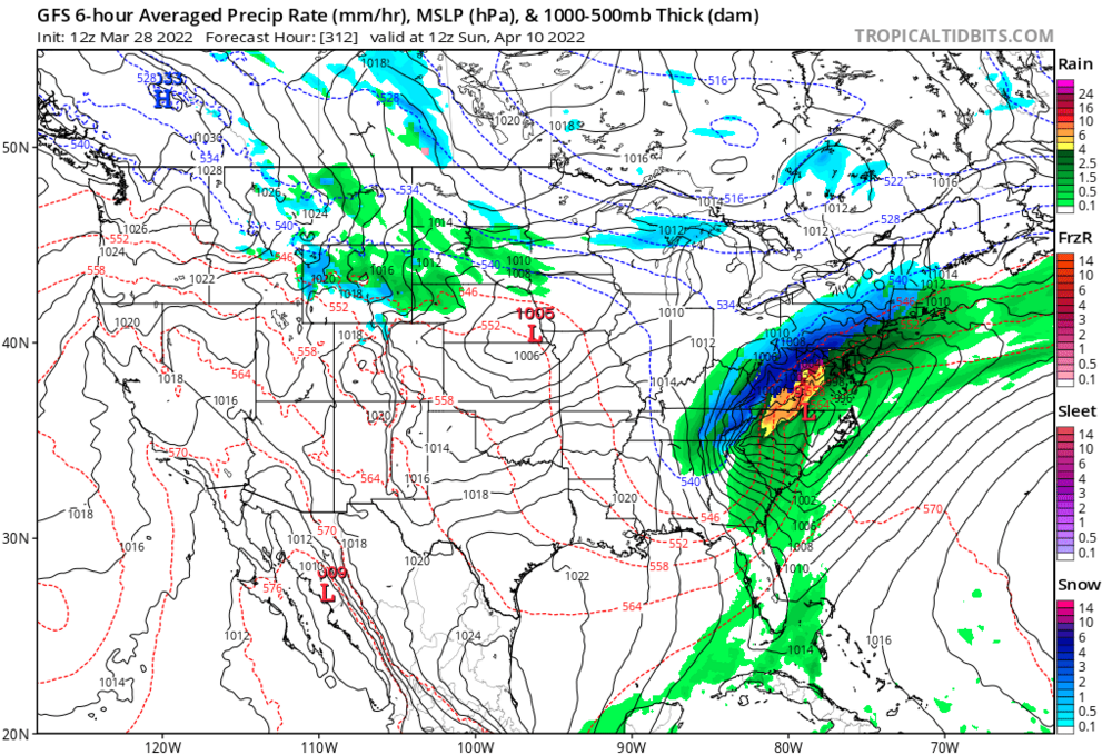
Gfs not ready to cave...stays the course.
-
Gfs holding steady for now.
Would like to see that wave strengthen a bit faster in the Carolinas. -
Waves are so tricky.
Blow up to soon we get slotted/rain, too late and everything goes east.


Pittsburgh, PA/Western PA Fall/Winter Discussion 2022-23
in Upstate New York/Pennsylvania
Posted
One thing I noticed about the Euro, is that it's maintaining decent wrap around 700mb moisture through Saturday. This might not mean anything, but with plenty of energy available, the potential for more snowfall is there at least.