

dta1984
-
Posts
1,698 -
Joined
-
Last visited
Content Type
Profiles
Blogs
Forums
American Weather
Media Demo
Store
Gallery
Posts posted by dta1984
-
-
What a storm! We traveled home yesterday from VA so got to experience the snow down there as well.
I'll get a measurement shortly, I see there's a 19" measurement from South Russell, with most between 12-15". Still moderate snow falling.
-
 3
3
-
-
It's not often we get favorable trends this close to the beginning. Looking like a great storm with the potential to be similar to one of the December storms last year.
-
2 hours ago, NEOH said:
Should have a much better idea with the 12z runs today.
I like where we sit to the NW side. The bleeding to the E seems to have halted. Ukie came west, and Cmc and GFS still give a good storm. We're very close to being big storm, just need a slight bump W.
-
26 minutes ago, WHEATCENT said:
we get the 0z euro on our side just to have everything correct east gfs and euro wise for 6z
I would not be too concerned with off runs. 0z suite looked great. GFS was a monster crush job. It's good to see the Euro continue to come W. We need a stronger secondary piece to pull the storm a bit to the W.
From CLE
Models trends over the last 48 hours have been tot he north and west with the track of the surface low, bringing better chances for snow to the region. The evolution of this system will be impacted by a secondary piece of energy moving through the northwest flow into the back of the trough on Sunday night. Depending on the strength of this secondary piece of energy, this can tend to pull the system westward, lending confidence to the recent trends we have seen in the deterministic models over the last few cycles.
-
2 hours ago, NEOH said:
It going to be an interesting few days of model watching for sure. Let's go for a track over PIT or State College.
Agreed! More model support other than the gfs would be nice. Though others seem to be ticking back west. I would think we would get some lake enhancement into play as well.
-
1 hour ago, NEOH said:
The immediate lakeshore in lake county tends to miss out on a lot of events... though with a due west flow you can do really well with a long fetch. Snowfall in the Southern portion of the county is much better with the elevation increase. If I were in lake county I would head to the Concord area just north of Chardon.
Looks like winds are W now keeping the current main band closer to the lake. Hopefully the turn more wnw later today.
-
Arw is about as good as it gets for flow over here. Long fetch + what looks like a connection to lake Michigan.
-
1
-
-
47 minutes ago, NEOH said:
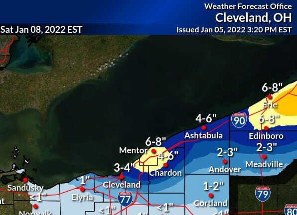
Most of the fluff from Friday melted from the rain. Nice to see the winter storm watch for 6-10" though. Placement of the band continues to look fairly similar. Ice was starting to form in the western basin which should increase significantly with the cold temps over the next few days.
Ya didn't take much to melt that fluff.
Short rangers still look pretty good for tomorrow, Rgem a hair north.
-
Rgem for Mon-Tues looks pretty similar to yesterday's event.

-
Had another 1/2" last night, bringing the event total to 7.5". Nice overachiever.
-
3" additional since this afternoon. Running total at 7". Looks like the band is drifting south at the moment.
-
A bit over 4" here. After a brief let up, the snow is picking back up. Looks like the band is wobbling south a bit.
-
20 minutes ago, NEOH said:
Picked up around 2" so far. Nice convergence band setting up from downtown on east. Winds are still WSW'erly here so the trough hasn't made it this far south yet.
Same here. Radar looks decent, looks like a band trying to form from the west side through Chagrin.
-
12 minutes ago, NEOH said:
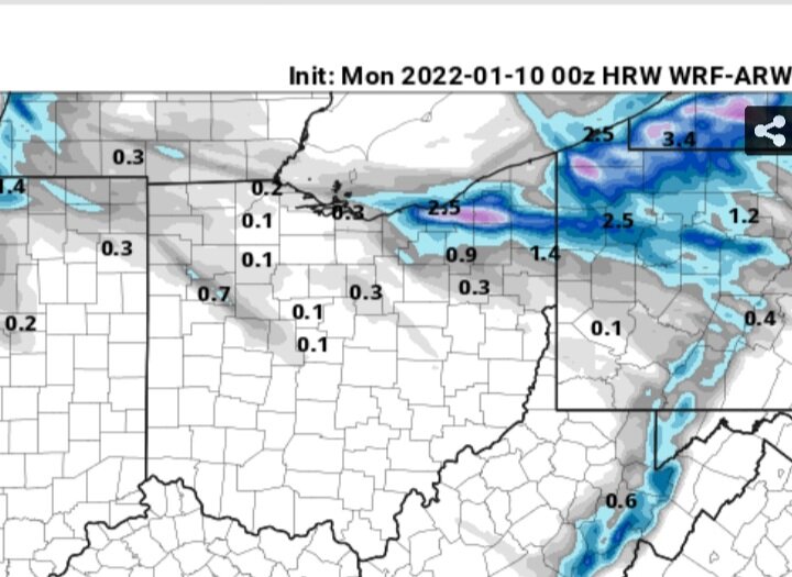
CLE's snowfall map from this afternoon looks like the RGEM, and to some degree the 18z nam. The 12z nam was much better, but 18z backed off on snowfall. 12z WRF-ARW brought the band pretty far south. Hoping the winds can turn enough to be more favorable for those south of 322.
Their map seems reasonable, the low end amounts will be nice. It'll be good to get the ground covered again. Cle mentions the possibility of the band getting hung up along the shore....so hoping that doesn't happen (although that would be good for @WHEATCENT). Looks like @OHweather had a part in that discussion write up!
-
Merry Christmas all! What a dud of a December. Hoping for some measurable snow next week to avoid a shutout at least.
-
22 hours ago, NEOH said:
Wouldn't be surprised to see a few inches tonight along the 322/Rt.6 corridor. Looks like winds may stay too westerly to push the snow this far south.
The majority of accumulating snow ended up E of Painesville and into Ashtabula county last night.
Looks like a boring stretch. I'm glad we at least are at 12" from Nov. Could be worse.. Bummer the lake is cooling off though.
-
Had thundersnow last night around 10pm with the Huron band. The snowfall was very intense, but must not have lasted too long. 2.5" additional is what fell overnight.
-
I've got 4" that fell yesterday and today. Currently getting light snow, small flakes.
-
1
-
-
The Canadian has been showing a snowy upcoming weekend into next week for Northern Ohio the past few runs. As far as I can tell...it's on it's own though...
-
35 minutes ago, NEOH said:
The LES was kind of bust locally. Around 1" IMBY. These short duration LES set-ups are tough.
Same here, looks like 4-5" in Chardon.
-
30 minutes ago, OHweather said:
I was a little surprised to wake up and see the forecast from CLE and the watch. It seems like they've cut it back some today, and as Jim's post mentioned went with advisories which is probably the route I'd go too. If I have time after work today I may re-draw my map a bit, overall no big changes to my thinking. May bring the 2"+ line a little farther south in some areas (especially eastern Cuyahoga and southern Geauga). I could see how someone in either southern Lake / northern Geauga or in the eastern half of inland Erie County PA sees 6" of snow, but I think most of that would come with the W-E oriented bands that will set-up the first portion of the event before the winds shift more WNW. Occasionally those stronger convergent bands ahead of an approaching trough can really rip, but they also tend to hug the eastern lakeshore and go into Erie County so may be too far north for many of the posters here. As the winds go WNW pre-dawn Friday I could still see how the lingering banding gets "stuck" for a few hours along the western lakeshore and drops an OK amount on parts of Cuyahoga and southwestern Geauga, but since the ridging will begin nosing in by then I don't think it'll quite have the same intensity as bands earlier in the night may have.
I suppose this is as good of a time as any to mention that I'll be moving back to the area in early December...to work at NWS CLE. I am excited to be able to move back to the area after a few winters, and of course am thrilled to be starting a career at the NWS. Hopefully the next several LES seasons keep us all on our toes!
Congrats man, that's awesome to hear! It's got to be extremely exciting to be able to get a job at the nws in your home area.
-
1
-
-
Winter storm watch, Cle seems pretty bullish.
-
1 hour ago, OHweather said:
I feel good about advisory criteria snow for parts of NE OH and NW PA Thursday night into early Friday right now. It's a briefly good lake effect set-up and with 850mb temps dipping to -8 to -10C it should pretty safely be cold enough to accumulate well away from the immediate lake (which hasn't been the case with any LES setup yet this fall...though the synoptic snow did well last weekend). Winds are mainly W for the bulk of the event but will gradually swing more WNW by early Friday before the ridging really clamps down on things, so in NE OH I think the heaviest probably falls near 322 or perhaps slightly north, but as the winds go WNW it should get into the rest of Geauga and even a decent chunk of Cuyahoga early Friday. I think it's generally a 2-5" snow inland from the lake for parts of Lake, northern Geauga, Ashtabula and Erie Co's but if the band stalls for a few hours over one spot like some models suggest there could locally be a bit more. For most of central and eastern Cuyahoga and spots like southern Geauga probably more like a 1-3" deal in the hills (and less closer to the immediate shoreline).
Should be a good quick hitting event. Cle mentions a 280 flow, not quite ideal for out here (I think 290 is our ideal), but still should get some accumulation as the band shifts.
-
4" total, less in the grass, and minimal on paved surfaces. Nice start to the season.
Northern Ohio Obs/Discussion Part 2
in Lakes/Ohio Valley
Posted
I'm going with 17" here, average of several measurements. Decent amount of blowing and drifting now.