

dta1984
-
Posts
1,698 -
Joined
-
Last visited
Content Type
Profiles
Blogs
Forums
American Weather
Media Demo
Store
Gallery
Posts posted by dta1984
-
-
3 hours ago, NEOH said:
Nice to walk outside this morning and feel the mild temps. Burke is at 50 while its 40 IMBY... that area really torches with a south wind. Going to a mess out there after the rain and snow melt.
Feels amazing out! Depth down to 6-8". Tomorrow will be a mess. Looks like some models trying to give us backside scraps on Fri.
-
3 hours ago, OHweather said:
Lake effect surprised last night…2” in Reminderville but have a couple spotter reports out east of 4”
2" here as well. Must have been a few cracks in the ice. Nice surprise. A few depth measurements avg around 18".
-
3 hours ago, NEOH said:
Yeah, heavy snow in Chagrin right now within that thin band.
Picked up an additional 1.5" throughout the morning. Going with a total of 12.5".
-
There's still some good returns heading NE...may be able to tack on an additional inch or so.
-
10 minutes ago, NEOH said:
This was a tough snow to measure... I'll go with 10-12" storm total. The snow was dense and tightly compacted by the wind. Great long duration event.
Yep same range I am coming up with. Definitely some deep drifts out there!
-
3 minutes ago, NEOH said:
Still snowing hard out there. Flake size has gotten better so I’d imagine lake enhancement is kicking in. Winds are strong its tough to measure. Great to see this is going to last until tomorrow morning. Will try to get a measurment in the am.
One of the better drifting snows we have had in a while. It's nasty out there. Tough to measure...I got between 7- 8" total so far from a few measurements.
-
1 hour ago, NEOH said:
It picked up quite a bit and flake size has improved. Check out the 12z NAM -- snows until tomorrow morning.
Looks great, in fact all short rangers look really good. Pretty amazing moisture feed all the way from TX.
-
1 hour ago, NEOH said:
Picked up an inch or so last night. Look forward to seeing what today brings. Wondering if the heaviest snow now falls just southeast of here. Hopefully a more amped NW solution works out... Models are probably struggling with the waves riding along the front.
The one wildcard is how much lake enhancement occurs. I'm guessing the ice shifted around quite a but so we should get some moisture off of the lake.
The flake size and intensity hasn't been efficient yet, but seems to be improving. I just measured 2" as of 9am.
-
Snow has started here. Remaining previous snowpack at 8.5" . We will have quite the glacier underneath the new snow.
-
26 minutes ago, Jonger said:
What radar are you using.....this has been hard to track due to DTX outage.
Thks is the radar I use. It's set for CLE, but you can change using the top left icon. Doesn't help you though with dtx being out sorry.
https://weather.cod.edu/satrad/nexrad/index.php?type=CLE-N0Q-0-24#
-
Everything still seems on track. Looks like a slight drying trend with the qpf if anything, but should still be a great storm.
-
Feels great outside at 47 degrees! Snowpack went from 15"-12" so far today.
Everything seems to still be on track. Gfs is definitely consistent with 12"+. Would prefer the CMC fall in line to feel a little more confident.
-
20 hours ago, BuffaloWeather said:
I feel so relieved. All is good in the world again. The Bengals defense held the Chiefs to 3 pts at home after halftime including OT and winning the toss...Incredible performance. Did anyone see what they did? They rushed 3 people and dropped everyone else back into coverage. Their d line man while way underpaid compared to ours were incredible and their LBS were better. I will now be watching the superbowl and watching tonights game!

Ya what a game it was! Loved the ending of the first half and into the second. KC got a little too confident at the end of the first half and walked away with 0... Love it!
I was pretty discouraged by the way the game started, but we have typically been a 2nd half team. That definitely showed up between Joe scrambling more and the D adjustments, amazing.
-
 3
3
-
-
@OHweather with another awesome short term write up today. Enjoying the format!
With the exception of the Canadian runs, all others are pretty favorable for us still. Hoping we don't melt too much tomorrow-weds.
-
58 minutes ago, NEOH said:
The 06z GFS would an all-timer for Northern Ohio. Still a long way to go but all good trends in the models with the southward shift.
Definitely some favorable trends. I'm hoping we can miss any significant icing. Should be a fun week to track.
-
20 minutes ago, NEOH said:
Picked up 3 inches since last night. That was definitely unexpected. Looks the arctic front stalled for awhile over this area. Still snowing nicely. This is one of the deeper snowpacks in recent memory IMBY.
Ya didn't expect that, radar still looks decent too.
-
Had just over an inch last night of fluffy snow. January is definitely making up for a dud December. Running season total right around 50".
-
It was snowing pretty hard early this morning. I came up with 3" total, yesterday+ overnight/morning. Pretty snowy past week!
-
10 minutes ago, OHweather said:
Solid light snow (but with smallish flakes) here right now too, started in the last half hour or so. If it does this until 7 or 8 PM and we grind out 2 or 3" I'd take it. Just adding to the pack at this point.
Same here. Is the overnight 1-3 fc coming from lake effect?
-
Hell of a game last night. Allen is the real deal! Won't even get into the OT rules.... Was hoping for a Cincy vs Bills afc championship like in 88. As a Bengals fan, there is room on our fellow small market team bandwagon for the playoffs
")
-
5
-
-
Had 4.75" just as this last band moves through. Probably make a run at 5" before the night is over. Definitely a nice surprise.
Let's see what tomorrow brings.... maybe a few more inches...
-
3 hours ago, NEOH said:
Getting a few decent bursts of snow off of the lake. These dry arctic air masses are never good for LES. Been awhile since we've had a lake huron connection this far west so that will help. Looks like the lake huron band is currently coming through Ashtabula county and headed west.
Surprised to see the WWA. Looks like the Huron band is pivoting this way.
-
On 1/18/2022 at 8:56 AM, NEOH said:
Looking at CLE's snowfall map the NAM seemed to have a good handle on snowfall totals.
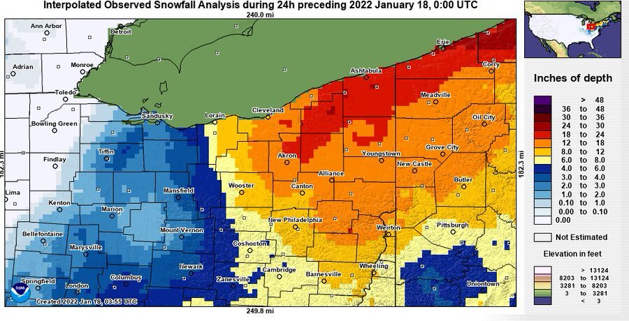
Pretty incredible how widespread the 12"+ area is.
-
31 minutes ago, BuffaloWeather said:
16.2" storm total, 40.3" on the year.
Had 17" at this end of Lake Erie, fairly widespread areas just south of the lake East of Cle between 12-19".
-
1
-
Northern Ohio Obs/Discussion Part 2
in Lakes/Ohio Valley
Posted
3.5" of snow and a little sleet this morning. Definitely a small layer of ice on the bottom. Still snowing pretty good at the moment.