

dta1984
-
Posts
1,698 -
Joined
-
Last visited
Content Type
Profiles
Blogs
Forums
American Weather
Media Demo
Store
Gallery
Posts posted by dta1984
-
-
3 hours ago, NEOH said:
Will there be full sampling today? Pretty much worst case scenario currently on the models. -- low cuts well west, winds behind the storm stay WSW'erly so any lake effect/enhanced snow would be along the immediate lakeshore up to WNY. Fits seasonal trends I guess
 .
.
Lol let's hope not.
Seems 12z runs bringing things a bit back east. Let's hope the trend continues with more sampling.
Going to be windy, that's for sure!
-
Right at 2" here overnight and this morning. Nice to get an overachiever after the slow start to winter.
-
 1
1
-
-
12 minutes ago, NEOH said:
Euro has been remarkably consistent with next weeks storm threat. GFS is all over the map, the CMC is fairly close to the Euro. Only 6 more days of model watching
Going to be a long week lol.
Last night's Euro was quite the storm, just on the 10:1 maps.
Definite potential to be snowy like. Christmas 2020.
-
20 minutes ago, NEOH said:
Euro ends with a somewhat similar solution. Different way to get with the initial primary low to the NW. Just nice to have a storm to track for a change.
Yep agreed, definitely liking the way things are starting to look as we get closer to Christmas.
-
1 hour ago, NEOH said:
Just under 3" IMBY last night/this morning. Most of that fell in a short period as the band came south... the band pushed north rather quickly after making it down to around 422.
Ya it sure moved quickly. Looks like eastern Cuyahoga did well with 6-8" near Lyndhurst.
-
Interesting that a few short rangers keep the bulk of the accumulation farther south, and not much near the lake shore.
-
1.75" here. Definitely underwhelming, but had low expectations. Hoping Saturday -Sunday trends a little better.
-
1 hour ago, NEOH said:
Looks like a fairly brief window for LES Wednesday night into Thursday. Shame to waste this LES potential with a WSW wind flow
") . Hoping for better trend with the kicker shortwave in today's runs...
. Hoping for better trend with the kicker shortwave in today's runs...
.SHORT TERM /WEDNESDAY NIGHT THROUGH FRIDAY NIGHT/...
The first notable lake effect snow event of the season still appears on tap for Wednesday night through Thursday evening, but general
excitement for snow for this portion of the lake has diminished slightly over the last 24 hours. The kicker shortwave trough that
pushes the low pressure system east of the region on Wednesday evening has trended further south for Wednesday night and while a
deeper trough could help with temperature profiles across the region. The orientation of this feature will also help low level
flow stay more westerly or even just south of west vs. the just north of west flow expounded upon in yesterday`s forecast. This will
have great repercussions for the snowfall forecast of the period.
Trends have not been favorable the past few days. Hoping for a last minute trend in our favor.
-
25 minutes ago, NEOH said:
Just a coating so far. The band has been just north here throughout the night. The 322 corridor probably had a couple of inches.
Ya Chardon cam looks like a few inches. Snowing nicely here now though.
-
Great writeup by @OHweatherhttps://www.americanwx.com/bb/topic/58383-some-thoughts-on-the-next-couple-months/
Looks like the possibility of some lake effect beginning next week.
-
 1
1
-
-
4 hours ago, OHweather said:
Parts of Lake and Geauga Counties got a bit more snow than we bargained for last evening into the overnight. Changing back to rain now, but would not be surprised to see a few inches in the higher terrain if people measure it early enough this morning. Some scattered power outages due to the wet snow on trees.
Officially on the board for the season. 3/4" snow here with just plain rain right now.
-
Looks like a good chance of first flakes next week. Seems like it will be the earliest we have seen them for a few years at least.
-
On 9/21/2022 at 9:11 AM, NEOH said:
Seems a little early but lots of color showing in the trees already. Looking forward to the squall line later today... then on to Fall tomorrow.
Fall is right on time this year. Leaves turning and even falling already. Hoping for a pleasant fall for a change.
-
1
-
-
20 hours ago, NEOH said:
First line of storms blew up just east of here on the Ohio/PA line. The area from Ashtabula on east has had the hot hand with storms this Summer. Hoping the line to the West can hold together for some action this evening. This has been one of the more boring Summers I can remember for t'storms locally.
Sure enough, that line did weaken once it got near 71. Still got some rain out of it though. Definitely been a calm summer.
-
On 7/18/2022 at 12:50 PM, NEOH said:
Picked up 2.40" of rain since yesterday. It has been dry locally so it was definitely much needed around here.
Finally a bit of relief after the extended dry period. Had some good rain overnight and early this morning as well. Grass is finally growing again.
-
3.75" here, very scenic out. Looking forward to 70s this weekend.
-
3 hours ago, NEOH said:
1..5” of snow last night. Checked out from the weather for awhile so wasn’t excepting that.
Sure is scenic outside this morning. Same here, I'm ready for Spring and 60s.
-
Just now, OHweather said:
A little over 1.5” here yesterday (about 0.5” in the morning that melted, then a little over an inch in the afternoon that started melting). 3.5” last night into this morning. So at roughly 5” for the event, but roughly 3 on the ground.
Similar here, measuring off my deck about 1.5" yesterday before noon and 4.5" after...total around 6".
-
Right around 4" here. Looks like a pretty widespread 3-5" east of 271. This afternoon could be interesting.. a few short rangers bring a lake effect band near the area with what looks like an upstream connection.
-
Snowing nicely out. Latest Rgem brings .75" qpf to the far east side.
-
17 hours ago, NEOH said:
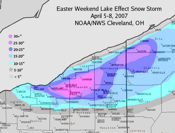
Definitely read to close the books on this winter. Pretty good winter overall considering how bad December was. Jan and Feb were cold and snowy... and we had snow cover for an extended period of time despite the brief thaws. DTA is probably keeping track but I'd guess we are at or slightly above average with snowfall at this point. Unless April 2007 comes along I'm ready to move on to Spring. That was the heaviest heart attack snow I've ever experienced.
Same here, ready for Spring unless it's a big event. I'm around 82" for the season including the 1" that fell last night. It's been a good season, and definitely one where storms for the most part have trended in our favor.
-
33 minutes ago, NEOH said:
Picked up 4” of lake effect last night. That was a surprise. Looks great with the ice on the trees.
Yep definitely very scenic out there this morning! I came up with 5.25" measuring off my deck. Includes whatever fell throughout the day yesterday as well.
-
1
-
-
6 hours ago, NEOH said:
Snow cover should be reduced to patches and piles today or tomorrow. Torching out there with full sun... really amazing how strong the sun feels this time of the season.
Ya snowcover is dwindling fast. Glad to get a few of the larger piles melted some more. Looks like back to winter starting Thurs evening.
-
1 hour ago, NEOH said:
Stopped home and measured just under 5". Looks like the lake effect is winding down now as the winds are turning.
Yep, right at 5" here. Looks like we will have a shot at a few more inches with the front tomorrow morning.

Northern Ohio Obs/Discussion Part 2
in Lakes/Ohio Valley
Posted
Same here. Interested to see when more short range models get into better range. The fv3 looks interesting, but it's only one model.