

dta1984
-
Posts
1,698 -
Joined
-
Last visited
Content Type
Profiles
Blogs
Forums
American Weather
Media Demo
Store
Gallery
Posts posted by dta1984
-
-
After a slow start and just a dusting overnight, right at 4" fell this morning as the band came south and hung out for a while.
-
A few of the short rangers showing a decent lake effect setup tonight. WWA for 3-6 seems about right.
-
I'm coming up with 6.25" for yesterday - this afternoon. Nice storm and right in line with the forecast.
-
 1
1
-
-
3 hours ago, NEOH said:
Moderate snow falling. Surprised to see forecast totals increase to 4-8". Dry slot if awfully close already.
Same here. Rates and flake size have increased recently, but unfortunately the temps are creeping up too. Maybe 1-2" down so far.
-
1 hour ago, WHEATCENT said:
as we approach amounts going down as per usual this winter

Still has the opportunity to be our biggest snow this year I believe. I have low expectations, but anything over 4" would be solid for the year.
-
37" Imby. Definitely the worst I've experienced out here. If only we could transition to a warm enjoyable spring...but of course it'll be 30s and crap for at least March.
-
On 2/14/2023 at 10:30 AM, NEOH said:
This Winter is about as bad it gets. We've had some clunkers recently but this is a different level. CLE is -25" for the season as of today... the departure is much higher in the snowbelt. The recent mild temps and sun have me in spring mode at this point. Sure, we'll likely see some snow later this month but I've moved on.
Spring fever today, 65 and sunny!
-
What an absolute dumpster fire of a winter. Lr doesn't look promising at all. Just about ready to move on to Spring.
-
1.5" new overnight. 5.5" total for the event. Not bad, and falls in line with the WWA that was issued.
-
One of those days where it snowed lightly just about all day. Right at 4" since overnight when it changed back to snow.
-
2" here, but rain has been mixing in. Possibly more fell, but it's very compacted now.
-
41 minutes ago, NEOH said:
Snow started around 6am. Snowing light to moderately at times. Heavier stuff to the south still to come through.
Starting to pick up a bit now. Looks like the current forecast of 2-3" is on track.
Interested in the rest of the week with the lake effect. Looks like several chance that will add up.
-
5 hours ago, OHweather said:
Slightly less than 1" new overnight pushing me to slightly less than 6" for a storm total. Should clear the 6" mark with the lingering activity this morning. Wednesday's system looks like a snow to rain to wrap-around/LES situation. It'll be quite spread out but the snowbelt should get a pretty decent amount between Wednesday morning and Thursday night.
What's your thoughts on the wind direction for les later in the week? Thought I saw mention of WNW in one of the cle discussions.
-
4.5" here so far. Perfect winter day with the steady snow falling, no wind and coating everything. Have to see if we tack on any more with the wrap around.
-
Current temp at 30. WWA for 2-4" seems to be a good call. Radar looks great to the SW , seems to be over performing in that area.
-
18 hours ago, NEOH said:
Its definitely not ideal with the marginal temps. The way this Winter is going I will take back to back weekends with snow.
Absolutely agree, take what we can!
Severe thunderstorm warning last night and accumulating snow this morning. Crazy lol.
-
1 hour ago, NEOH said:
Severe in mid Jan is never high on the list. Clearing out nicely down in Central OH. Too bad the late weekend system is fading southeast. Big changes with that system on the models the past couple of days.
Looks like the Canadian/Rgem and Nam still bring a bit of snow in on Fri and again Sunday. Temps still marginal though.
-
3 hours ago, NEOH said:
Picked up 2.5" last night. Nice scenery with the wet snow covering everything this morning. Looks like this will under perform with snow totals but at least it will look like winter for a couple of days. With the strong NNW'erly winds I'm surprised the snow isn't pushing farther inland.
Very scenic out there this morning! About the same here as well. Driving to Chardon this morning, seems like most places close to the same 2-4" eyeballing.
-
6 hours ago, NEOH said:
Models still look good... even increased snow totals across the the lakeshore counties. The ground will be wet, and with marginal temps there will likely be a lot of melting to start.
There will certainly be a lot going against efficient accumulations.
CLE pretty bullish with 6"+ across the snowbelt.
-
3 hours ago, NEOH said:
The 12z suite have a general 3-6" across northern ohio with the late week storm. Really low confidence but that would likely be the largest storm of the season.
Ya take what we can this winter since it seems snow is hard to come by. Should be a scenic plastering with the marginal temps.
-
1.5" here throughout the morning and day yesterday. Definitely seemed like a spring time snow vs a heart of winter snow. What a clunker so far.
-
 1
1
-
-
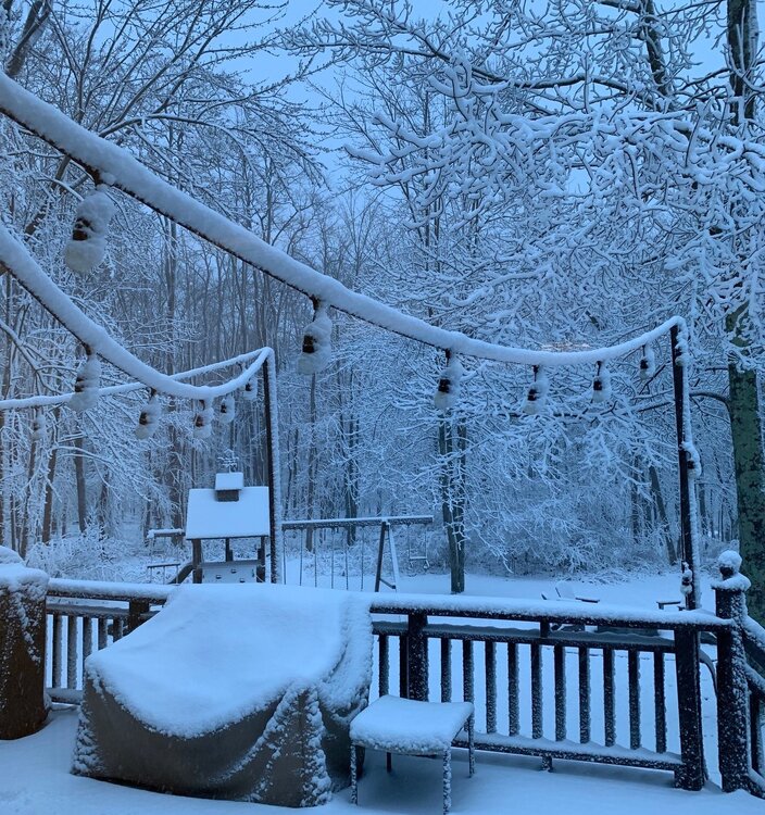
Snow falling and snow on the ground
 . Merry Christmas all.
-
 1
1
-
-
3 minutes ago, WHEATCENT said:
1st blizzard warning in 10 years
Yep it's brutal out there! Was thinking at least the lakeshore would get upgraded No idea on snow amounts so far....2-4" possibly.
-
1
-
-
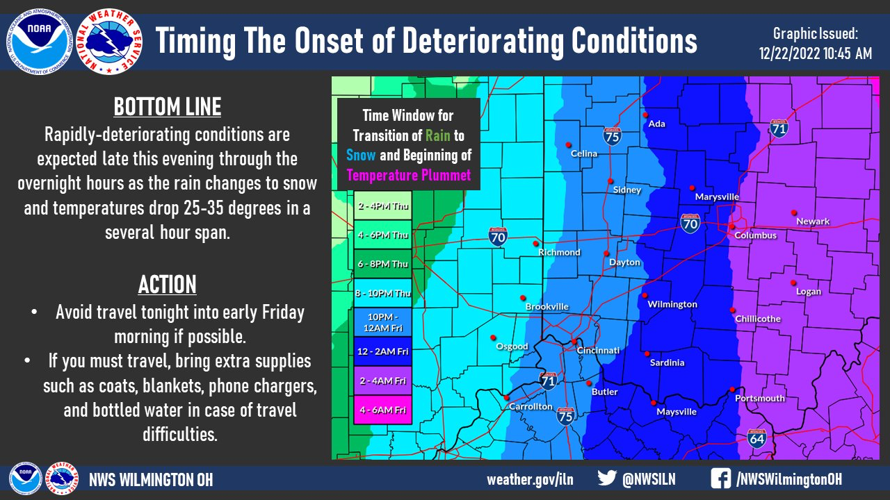
9 hours ago, Floydbuster said:
Does anyone have a time estimate for the exact temperature drop throughout Eastern Ohio? I almost want to stand outside to experience it, if indeed it happens within just a few minutes. The GFS shows it around 12-5am Friday morning.
Saw this graphic from NWS ILN. For us, looks like 4-6am as of now.


Northern Ohio Obs/Discussion Part 2
in Lakes/Ohio Valley
Posted
60s and 70s with dry weather sound great next week. Hopefully it has some staying power. Should be a good week for some yard cleanup after the high wind events we've had.