jayyy
-
Posts
4,542 -
Joined
-
Last visited
Content Type
Profiles
Blogs
Forums
American Weather
Media Demo
Store
Gallery
Everything posted by jayyy
-
3/12 Event: Winters Last Hurrah at Least East of Mountains
jayyy replied to Weather Will's topic in Mid Atlantic
Don’t think so. Why would they? -
3/12 Event: Winters Last Hurrah at Least East of Mountains
jayyy replied to Weather Will's topic in Mid Atlantic
10” !? Uh. Yes please -
3/12 Event: Winters Last Hurrah at Least East of Mountains
jayyy replied to Weather Will's topic in Mid Atlantic
Tornado watches on the southern flank, snow stretching from buffalo to Mississippi, and strong convection popping up off the coast in Virginia. Fuggin Smarch storms, baby!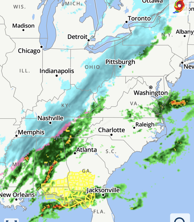
-
3/12 Event: Winters Last Hurrah at Least East of Mountains
jayyy replied to Weather Will's topic in Mid Atlantic
Add it to the list of models printing 6” IMBY. Not sure I’ve ever seen so many models agree on me seeing WSW criteria while I have an advisory up. Oh well. It’s a good thing being under an advisory vs WSW vs blizzard warning means absolutely nothing as it pertains to the final outcome. -
3/12 Event: Winters Last Hurrah at Least East of Mountains
jayyy replied to Weather Will's topic in Mid Atlantic
Definitely In line with ground truth and current OBS. Folks on Facebook and twitter down south are pretty much indicating a clean and quick transition over to heavy snow from rain. (Thunder snow reports as well) To me, likely means models like the NAM were overdoing the sleet aspect of this storm. -
3/12 Event: Winters Last Hurrah at Least East of Mountains
jayyy replied to Weather Will's topic in Mid Atlantic
0z HRW WRF 2 (I know, not a great model blah blah) with roughly 6-8 hours of accumulating snow after the changeover depending on location. It and the HRRR have been extremely consistent all day -
3/12 Event: Winters Last Hurrah at Least East of Mountains
jayyy replied to Weather Will's topic in Mid Atlantic
It was a watch until an hour ago -
3/12 Event: Winters Last Hurrah at Least East of Mountains
jayyy replied to Weather Will's topic in Mid Atlantic
Wonder what occurred just over 6 years ago! -
3/12 Event: Winters Last Hurrah at Least East of Mountains
jayyy replied to Weather Will's topic in Mid Atlantic
Here we go Here we go, what? The hi res FV3 uses the old GFS. Who cares if it stepped back a bit. It’s not a trend setter lol -
3/12 Event: Winters Last Hurrah at Least East of Mountains
jayyy replied to Weather Will's topic in Mid Atlantic
Ground truth looks great so far. Evolution happening as expected. Perhaps a tad more robust than I expected at this juncture -
3/12 Event: Winters Last Hurrah at Least East of Mountains
jayyy replied to Weather Will's topic in Mid Atlantic
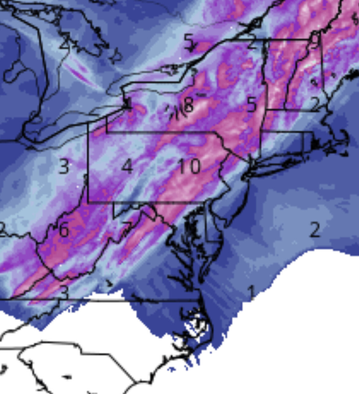
Euro GFS NAM RAP HRRR HRDPS blend here is north of 6”. Sold. Go ahead. Keep my advisory up, LWX. We oddly (and obviously 100% coincidentally) tend to overperform when we have advisories hoisted during marginal events more often than we meet warning criteria during marginal events. I’ll take the advisory knowing we’ll likely exceed the upper end and could be upgraded mid storm. There’s something awesome about having your advisory upgraded mid storm with heavy paste falling -
3/12 Event: Winters Last Hurrah at Least East of Mountains
jayyy replied to Weather Will's topic in Mid Atlantic
HERPDYDERP with a pretty decent cutoff. 6-8” north of 70 from carroll county and points WNW (with 10” lollies) and 1-3” near the metros along 95
-
3/12 Event: Winters Last Hurrah at Least East of Mountains
jayyy replied to Weather Will's topic in Mid Atlantic
Doubt that plays out as depicted, but that would surely suck for some. I personally dig this run for my area -
3/12 Event: Winters Last Hurrah at Least East of Mountains
jayyy replied to Weather Will's topic in Mid Atlantic
You know it! looking like a classic setup for a #MoCoHoCoDeathBand -
3/12 Event: Winters Last Hurrah at Least East of Mountains
jayyy replied to Weather Will's topic in Mid Atlantic
24 here. Based on OBS shared by my friends in central Ohio… it’s very much coming. They went from 60 to snow yesterday to this morning. -
3/12 Event: Winters Last Hurrah at Least East of Mountains
jayyy replied to Weather Will's topic in Mid Atlantic
Huh? 0.5-1” for who? Lmao -
3/12 Event: Winters Last Hurrah at Least East of Mountains
jayyy replied to Weather Will's topic in Mid Atlantic
I know a lot of folks either focus on far NW areas or the immediate metro areas….but keep in mind that the area of best lift often occurs by the rain/snow line. Highly possible the jackpot ends up being somewhere between Winchester and Baltimore or DC. MoCo & HoCo could be in a prime position as far as being cold enough for snow and far enough SE for more intense precip. Fairly confident someone is going to successfully walk that tight rope and see 6-8 out of this. -
3/12 Event: Winters Last Hurrah at Least East of Mountains
jayyy replied to Weather Will's topic in Mid Atlantic
FV3-Hires also gets it done. -
3/12 Event: Winters Last Hurrah at Least East of Mountains
jayyy replied to Weather Will's topic in Mid Atlantic
WRF-ARW — add it to the list. Very similar outcome to other mesos -
3/12 Event: Winters Last Hurrah at Least East of Mountains
jayyy replied to Weather Will's topic in Mid Atlantic
The @losetoa6 storm! We should be money for this one! Classic march setup for our latitude to cash in -
3/12 Event: Winters Last Hurrah at Least East of Mountains
jayyy replied to Weather Will's topic in Mid Atlantic
At this point.. pretty much no major model shows MBY getting less than 4-6” in under 8 hours. I taketh. -
3/12 Event: Winters Last Hurrah at Least East of Mountains
jayyy replied to Weather Will's topic in Mid Atlantic
Appreciate the inclusion in your personal 4-8” jack zone -
3/12 Event: Winters Last Hurrah at Least East of Mountains
jayyy replied to Weather Will's topic in Mid Atlantic
Suspect we’ll be seeing WWAs in Baltimore and DC proper by 4 PM and WSW’s from Winchester to the Cotocins over though northern carroll county and northern Baltimore county if current looks hold or improve -
3/12 Event: Winters Last Hurrah at Least East of Mountains
jayyy replied to Weather Will's topic in Mid Atlantic
Reeeeeally starting to like what I’m seeing for the corridor from MBY to yours. 4-6” looking likely. -
3/12 Event: Winters Last Hurrah at Least East of Mountains
jayyy replied to Weather Will's topic in Mid Atlantic
HRRR NAM Euro RGEM - all on board. Probably the combination we want on our side at this juncture (sub 24 hours). Only “hold out” of importance is the GFS, which still paints a few inches over the entire sub forum tomorrow. Barring some wild swing back in the other direction at 18z and 00z, I’m definitely liking our chances here. NW folks should be getting excited, no doubt.